
Timéré
Location of Timéré in Niger |

Timéré is a village in the Niamey V arrondissement of the city of Niamey in Niger .
That of a traditional village chief (chef traditionnel) led village is located on the River Niger in the east of the rural area of Niamey V, at the state border with Burkina Faso leading National Straße 27 . The surrounding settlements include the village of Gorou Banda in the northwest, the village of Gorou Kirey in the southeast, the hamlet of Dantcha in the south and the hamlet of Langayé in the southwest.
Timéré already existed in the 1970s when the city of Niamey began to expand to the right bank of the Niger. The village was outside the city limits of Niamey until the end of the 20th century and belonged to the arrondissement of Kollo .
At the 2012 census, Timéré had 652 inhabitants who lived in 76 households. At the 2001 census, the population was 226 in 34 households, and at the 1988 census, the population was 163 in 26 households.

To the west of the village is the Gorou Banda diesel power plant , which went into operation in 2017.
- Views of Timéré
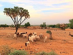
Cattle and Doum Palm (2018)

Entrance to the town on national road 27 (2018)

Street scene at dusk (2018)
,_cattle_and_Doum_palm_.jpg)
,_entering_the_village.jpg)
,_roadside_scene.jpg)
Web links
Individual evidence
- ↑ Carte de référence: Niger - Région de Tillabéri - Département de Torodi. (PDF) In: REACH Resource Center. March 21, 2018, accessed May 2, 2019 (French).
- ↑ République du Niger. Niamey et ses environs. Echelle 1: 20000 . Map. Institut Géographique National, Paris 1978 ( esdac.jrc.ec.europa.eu [PDF; accessed April 29, 2019]).
- ^ A b Recensement Général de la Population 1988: Répertoire National des Villages du Niger . Bureau Central de Recensement, Ministère du Plan, République du Niger, Niamey March 1991, p. 217 ( web.archive.org [PDF; accessed May 4, 2019]).
- ↑ Répertoire National des localites (ReNaLoc). (RAR) Institut National de la Statistique de la République du Niger, July 2014, p. 719 , accessed on 7 August 2015 (French).
- ^ Répertoire National des Communes (RENACOM). (RAR) Institut National de la Statistique de la République du Niger, accessed on November 8, 2010 (French).
- ^ Inauguration de la Centrale thermique diesel de Gorou Banda, vers la fin de calvaire des Niaméens. In: Tamtam Info. April 1, 2017, accessed June 3, 2019 (French).
Coordinates: 13 ° 26 ' N , 2 ° 8' E