
Gorou Kirey
Location of Gorou Kirey in Niger |

Gorou Kirey (also: Gorou Kiré , Gorou Kirèye ) is a village in the Niamey V Arrondissement of the city of Niamey in Niger .
The village, run by a traditional chief (chef traditionnel) , is located on the national road 27 on the south-eastern edge of the rural area of Niamey V. The surrounding settlements in Niamey V include the village of Timéré in the north-west and the hamlet of Dantcha in the west. The rural community of Youri extends southeast of Gorou Kirey . Gorou Kirey is located on the Niger River . The dry valley of the same name, Gorou Kirey , which flows into the Niger and has a length of 8 kilometers and a catchment area of 22.6 square kilometers, runs near the village . The place name comes from the Zarma language . The word gorou means "dry valley" and the word kirey means "red". Gorou Kirey is accordingly the "red dry valley".
The village already existed in the 1970s when the city of Niamey began to expand to the right bank of the Niger. Gorou Kirey was outside the city limits of Niamey until the end of the 20th century and belonged to the arrondissement of Kollo . In 2005 and 2009 the Festival International de la Mode en Afrique (FIMA) took place in Gorou Kirey. In the course of this, a concrete catwalk as well as a street and a parking lot made of laterite were created.
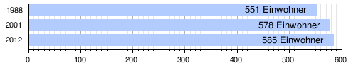
At the 2012 census, Gorou Kirey had 585 residents who lived in 69 households. At the 2001 census, the population was 578 in 87 households, and at the 1988 census, the population was 551 in 68 households.
There is a primary school in the village.
literature
- Binta Salam dite Salamatou Mahamane Labo: Cones de déjection. Dynamique et potentialité agricole, cas des basins versant de Boubon et de Gorou Kirey . Faculté d'Agronomie, Université Abdou Moumouni de Niamey, Niamey 2012.
- C. Thévoz, I. Ousseini, J.-P. Bergoeing: Aspects geomorphologiques de la vallée du Niger au sud de Niamey (Secteur Saga Gourma - Gorou Kirey) . In: Revue de Géographie Alpine . Vol. 1, 1994, pp. 65-80 .
Individual evidence
- ↑ Carte de référence: Niger - Région de Tillabéri - Département de Torodi. (PDF) In: REACH Resource Center. March 21, 2018, accessed May 2, 2019 (French).
- ↑ a b Ibrahim Mamadou: La dynamique accélérée des koris de la région de Niamey et ses conséquences sur l'ensablement du fleuve Niger . Thèse de doctorat Ph.D. Université Abdou Moumouni de Niamey / Université Paris 1 Panthéon-Sorbonne, Niamey / Paris 2012, p. 127–128 ( researchgate.net [PDF; accessed April 20, 2019]).
- ↑ Jean-Pierre Olivier de Sardan: Les Wogo du Niger (= Etudes nigériennes . No. 20 ). IFAN, Niamey 1966, p. 14 .
- ↑ République du Niger. Niamey et ses environs. Echelle 1: 20000 . Map. Institut Géographique National, Paris 1978 ( esdac.jrc.ec.europa.eu [PDF; accessed April 29, 2019]).
- ^ A b Recensement Général de la Population 1988: Répertoire National des Villages du Niger . Bureau Central de Recensement, Ministère du Plan, République du Niger, Niamey March 1991, p. 216 ( web.archive.org [PDF; accessed May 4, 2019]).
- ^ Editions précédentes. Festival International de la Mode en Afrique, accessed on April 30, 2019 (French).
- ↑ Répertoire National des localites (ReNaLoc). (RAR) Institut National de la Statistique de la République du Niger, July 2014, p. 718 , accessed on 7 August 2015 (French).
- ^ Répertoire National des Communes (RENACOM). (RAR) (No longer available online.) Institut National de la Statistique de la République du Niger, archived from the original on January 9, 2017 ; Retrieved November 8, 2010 (French). Info: The archive link was inserted automatically and has not yet been checked. Please check the original and archive link according to the instructions and then remove this notice.
- ↑ Issa Mamane Manirou: Etude diagnostique des conditions d'accès à l'eau, l'hygiène et l'assainissement dans les écoles publiques de l'arrondissement primaires communal V de la ville de Niamey, Niger . Mémoire de fin d'étude. Annexes. 2iE Institut International de l'Eau et de l'Environnement, Ouagadougou 2016, p. II ( documentation.2ie-edu.org [PDF; accessed June 3, 2019]).
Coordinates: 13 ° 26 ' N , 2 ° 9' E