
Kirkissoye
|
Kirkissoye district |
|
|---|---|
| Coordinates | 13 ° 29 ′ N , 2 ° 6 ′ E |
| Basic data | |
| Country | Niger |
| Niamey | |
| Arrondissement | Niamey V |
| ISO 3166-2 | NE-8 |
| Residents | 28,428 (2012) |
Kirkissoye (also: Kirkissoy ) is a district ( French quartier ) in the Arrondissement Niamey V of the city of Niamey in Niger .
geography

The district is located in the east of the urban area of Niamey V. The neighboring districts are Pont Kennedy in the northwest and Gawèye in the north and, on both sides of National Road 27 , Saguia in the south and Banga Bana in the west. In the northeast of Kirkissoye is the informal settlement of Nialga . The village center of Kirkissoye covers an area of around 25.6 hectares , while the expansion areas of the district extend over a total area of around 135.3 hectares. The district lies on an alluvial floor , which mainly allows infiltration. There the groundwater is at risk of being contaminated. In the north, however, the groundwater level is so high that no infiltration is possible, which in turn increases the risk of flooding. Rainwater collects especially in the pits in the district.
The standard scheme for street names in Kirkissoye is rue KI 1 , with the French rue for street followed by KI for Kirkissoye and finally a number. This goes back to a project to name streets in Niamey in 2002, in which the city was divided into 44 zones, each with its own letter abbreviations. These zones mostly do not coincide with the administrative boundaries of the eponymous districts. The rue KI 1 scheme is also used in the neighborhoods of Kirkissoye.
history
The settlement existed before 1937, the year when the development of various districts in Niamey began in Plateau on the other bank of the Niger. The village of Kirkissoye was incorporated into Niamey in the 1970s after the Kennedy Bridge was built over the Niger River , which encouraged the city to expand to the right bank of the Niger. Fulbe residents in the village sold land to immigrants from the countryside and from the city center where housing had become too expensive. While the Fulbe continued irrigated agriculture and cattle breeding, Kirkissoye grew into a district with a very heterogeneous population. Especially at the turn of the 20th to the 21st century, the area and population of the city district was greatly enlarged. In 2007, Kirkissoye was one of the venues for the first edition of the Pripalo open-air cultural festival under the direction of Achirou Wagé . The relocation of around 750 flood-affected households from the Kirkissoye, Karadjé , Lamordé and Nogaré districts to the new Séno district was completed in February 2013.
population
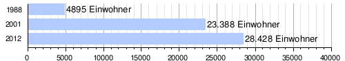
At the 2012 census, Kirkissoye had 28,428 inhabitants who lived in 4,510 households. At the 2001 census the population was 23,388 in 3,572 households and at the 1988 census the population was 4,895 in 791 households.
Economy and Infrastructure
The wet rice cultivation on a total area of 100 hectares was introduced 1964th The cultivation areas were renovated in 1988. The rice monocultures are irrigated with electric pumps. There are two harvest seasons in the year. The dairy Economic - Cooperative of Kirkissoye produces significant amounts of milk and dairy products.
The public primary school Ecole primaire de Kirkissoye was founded in 1966. There are a total of seven primary schools in the district. The houses are mostly made of adobe bricks and there are few thatched huts, unlike in poorer parts of Niamey.
literature
- Issaka Badio: Typology of the maraîchers des Sites de Nogaré, Kirkissoye, Lamordé, Néini Goungou, Diamioyoye et analyze de leurs stratégies de production . Faculté d'Agronomie, Université Abdou Moumouni de Niamey, Niamey 2005.
Web links
Individual evidence
- ^ The Study on Sanitation Improvement for the Niamey City in Republic of Niger. Appendix F: Existing Urban Conditions. (PDF) Japan International Cooperation Agency (JICA), August 2000, pp. F-1 and F-4 , accessed on April 19, 2019 .
- ↑ Hamadou Issaka, Dominique Badariotti: Les inondations à Niamey, enjeux autour d'un phenomène complexe . In: Cahiers d'Outre-Mer . No. 263 , September 2013, p. 384 ( openedition.org [accessed April 21, 2019]).
- ↑ a b Dossou Modeste Landry: Report de stage rural au district sanitaire du Vème arrondissement de Niamey. Université Abdou Moumouni de Niamey, 2014, accessed on May 12, 2019 (French).
- ↑ Catherine Farvacque-Vitkovic, Lucien Godin, Hugues Leroux, Florence Verdet, Roberto Chavez: Street Addressing and the Management of Cities . World Bank, Washington, DC 2005, ISBN 0-8213-5815-4 , pp. 85 and 89 .
- ↑ Apollinaire Tini: La gestion des déchets solid ménagers à Niamey au Niger: essai pour une stratégie de gestion durable . Thèse de doctorat. Institut National des Sciences Appliquées de Lyon, Lyon 2003, p. 44–45 ( insa-lyon.fr [PDF; accessed May 1, 2019]).
- ↑ Kokou Henri Motcho: Niamey, Garin captan Salma ou l'histoire du peuplement de la ville de Niamey . In: Jérôme Aloko-N'Guessan, Amadou Diallo, Kokou Henri Motcho (eds.): Villes et organization de l'espace en Afrique . Karthala, Paris 2010, ISBN 978-2-8111-0339-2 , pp. 23 .
- ^ Patrick Gilliard: L'extrême pauvreté au Niger. Mendier ou mourir? Karthala, Paris 2005, ISBN 2-84586-629-1 , p. 144 and 148 .
- ↑ Ibrahim A. Tikiré: Lancement du festival Pripalo. In: Niger Diaspora. July 19, 2007, accessed October 23, 2019 (French).
- ^ Monthly Humanitarian Situation Report, UNICEF Niger. January – February 2013. (PDF) UNICEF , February 2013, p. 1 , accessed on June 7, 2019 .
- ↑ Répertoire National des localites (ReNaLoc). (RAR) Institut National de la Statistique de la République du Niger, July 2014, p. 718 , accessed on 7 August 2015 (French).
- ^ Répertoire National des Communes (RENACOM). (RAR) (No longer available online.) Institut National de la Statistique de la République du Niger, archived from the original on January 9, 2017 ; Retrieved November 8, 2010 (French). Info: The archive link was inserted automatically and has not yet been checked. Please check the original and archive link according to the instructions and then remove this notice.
- ↑ Recensement Général de la Population 1988: Répertoire National des Villages du Niger . Bureau Central de Recensement, Ministère du Plan, République du Niger, Niamey March 1991, p. 226 ( archive.org [PDF; accessed May 4, 2019]).
- ↑ La recherche multidisciplinaire au DFPV. Document de Base . Center Régional AGRHYMET, Niamey October 1996, p. 9 ( cilss.bf [PDF; accessed June 7, 2019]).
- ↑ Daniel Barreteau, Ali Daouda: Systèmes éducatifs et multilinguisme au Niger. Results scolaires, double flux . Orstom / Université Abdou Moumouni de Niamey, Paris / Niamey 1997, ISBN 2-7099-1365-8 , p. 88 ( ird.fr [PDF; accessed on May 29, 2019]).
- ↑ Issa Mamane Manirou: Etude diagnostique des conditions d'accès à l'eau, l'hygiène et l'assainissement dans les écoles publiques de l'arrondissement primaires communal V de la ville de Niamey, Niger . Mémoire de fin d'étude. Annexes. 2iE Institut International de l'Eau et de l'Environnement, Ouagadougou 2016, p. II ( 2ie-edu.org [PDF; accessed June 3, 2019]).
- ^ Patrick Gilliard: L'extrême pauvreté au Niger. Mendier ou mourir? Karthala, Paris 2005, ISBN 2-84586-629-1 , p. 149 .