
Saga Gourma
Location of Saga Gourma in Niger |

Saga Gourma (also: Sagagourma ) is a village in the Niamey V arrondissement of the city of Niamey in Niger .
That of a traditional village chief (chef traditionnel) led village is located on the River Niger in the east of the rural area of Niamey V, at the state border with Burkina Faso leading National Straße 27 . The surrounding settlements include the Saguia district in the northwest, the village of Gorou Banda in the southeast and the hamlet of Boulel in the west. At Saga Gourma runs a dry valley that flows into the Niger , the Saga Gourma Gorou . The dry valley has a length of 20 kilometers and a catchment area of more than 230 square kilometers. The word gorou comes from the Zarma language and means "dry valley".
The French explorer Georges Joseph Toutée , who was traveling on the Niger at the end of the 19th century, mentioned Saga Gourma, the village of Gourma , as a counterpart to the Hausa settlement Saga on the opposite bank of the river. The village was outside the city limits of Niamey until the end of the 20th century and belonged to the arrondissement of Kollo .
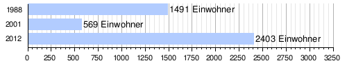
At the 2012 census, Saga Gourma had 2,403 residents who lived in 311 households. At the 2001 census, the population was 569 in 86 households, and at the 1988 census, the population was 1,491 in 184 households.
In Saga Gourma there is a simple health center (case de santé) and a primary school. The Gorou Banda diesel power plant , which went into operation in 2017, is located south of the village .
literature
- C. Thévoz, I. Ousseini, J.-P. Bergoeing: Aspects geomorphologiques de la vallée du Niger au sud de Niamey (Secteur Saga Gourma - Gorou Kirey) . In: Revue de Géographie Alpine . Vol. 1, 1994, pp. 65-80 .
Individual evidence
- ↑ Carte de référence: Niger - Région de Tillabéri - Département de Torodi. (PDF) In: REACH Resource Center. March 21, 2018, accessed May 2, 2019 (French).
- ↑ Ibrahim Mamadou: La dynamique accélérée des koris de la région de Niamey et ses conséquences sur l'ensablement du fleuve Niger . Thèse de doctorat Ph.D. Université Abdou Moumouni de Niamey / Université Paris 1 Panthéon-Sorbonne, Niamey / Paris 2012, p. 127 ( researchgate.net [PDF; accessed April 20, 2019]).
- ↑ Georges Joseph Toutée: You Dahomey au Sahara. La nature et l'homme . 2nd Edition. Colin, Paris 1907, p. 123 .
- ^ A b Recensement Général de la Population 1988: Répertoire National des Villages du Niger . Bureau Central de Recensement, Ministère du Plan, République du Niger, Niamey March 1991, p. 217 ( web.archive.org [PDF; accessed May 4, 2019]).
- ↑ Répertoire National des localites (ReNaLoc). (RAR) Institut National de la Statistique de la République du Niger, July 2014, p. 719 , accessed on 7 August 2015 (French).
- ^ Répertoire National des Communes (RENACOM). (RAR) Institut National de la Statistique de la République du Niger, accessed on November 8, 2010 (French).
- ^ Dossou Modeste Landry: Rapport de stage rural au district sanitaire du Vème arrondissement de Niamey. Université Abdou Moumouni de Niamey, 2014, accessed on May 12, 2019 (French).
- ↑ Issa Mamane Manirou: Etude diagnostique des conditions d'accès à l'eau, l'hygiène et l'assainissement dans les écoles publiques de l'arrondissement primaires communal V de la ville de Niamey, Niger . Mémoire de fin d'étude. Annexes. 2iE Institut International de l'Eau et de l'Environnement, Ouagadougou 2016, p. II ( documentation.2ie-edu.org [PDF; accessed June 3, 2019]).
- ^ Inauguration de la Centrale thermique diesel de Gorou Banda, vers la fin de calvaire des Niaméens. In: Tamtam Info. April 1, 2017, accessed June 3, 2019 (French).
Coordinates: 13 ° 27 ' N , 2 ° 7' E