
Hogolé
Location of Hogolé in Niger |

Hogolé (also: Ogolé ) is a hamlet in the Arrondissement Niamey V of the city of Niamey in Niger .
The hamlet is located on the southern edge of the rural area of Niamey V. The hamlet of Bibia in the north is one of the surrounding settlements . A side valley of the 17-kilometer-long dry valley Kourtéré Gorou runs near Hogolé , which flows into the Niger River behind Kourtéré .
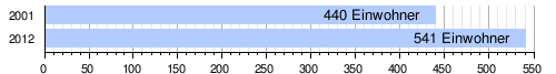
At the 2012 census, Hogolé had 541 inhabitants who lived in 52 households. At the 2001 census, the population was 440 in 66 households.
There is a primary school in the hamlet.
Individual evidence
- ↑ Carte de référence: Niger - Région de Tillabéri - Département de Torodi. (PDF) In: REACH Resource Center. March 21, 2018, accessed May 2, 2019 (French).
- ↑ Ibrahim Mamadou: La dynamique accélérée des koris de la région de Niamey et ses conséquences sur l'ensablement du fleuve Niger . Thèse de doctorat Ph.D. Université Abdou Moumouni de Niamey / Université Paris 1 Panthéon-Sorbonne, Niamey / Paris 2012, p. 127 and 135 ( researchgate.net [PDF; accessed April 20, 2019]).
- ↑ Répertoire National des localites (ReNaLoc). (RAR) Institut National de la Statistique de la République du Niger, July 2014, p. 718 , accessed on 7 August 2015 (French).
- ^ Répertoire National des Communes (RENACOM). (RAR) (No longer available online.) Institut National de la Statistique de la République du Niger, archived from the original on January 9, 2017 ; Retrieved November 8, 2010 (French). Info: The archive link was inserted automatically and has not yet been checked. Please check the original and archive link according to the instructions and then remove this notice.
- ↑ Journée mondiale de lutte contre le paludisme 2016: “en finir définitivement avec le paludisme”. WHO Regional Office for Africa, accessed June 3, 2019 (French).
Coordinates: 13 ° 24 ' N , 2 ° 1' E