
Yoware
Location of Yowaré in Niger |

Yowaré (also: Yawaré ) is a hamlet in the Arrondissement Niamey V of the city of Niamey in Niger .
The hamlet is located in the west of the rural area of Niamey V, on the national road 6 leading to the state border with Burkina Faso . The surrounding hamlets include Hama Gatio in the north, Bibia in the south, Bougoum in the southwest and Lougadjam and Tchéna Thayia in the west. At Yowaré runs a side valley of the 17 kilometer long dry valley Kourtéré Gorou , which flows into the Niger River behind Kourtéré . The soils in Yowaré consist of sandy clay loam. Local fruit trees such as mangoes , guavas , papayas and citrus plants as well as exotic trees such as eucalyptus and neem trees grow on the farms, as well as the shrub Waltheria indica . Sand mallow and Cenchrus biflorus , among others, thrive in the herb layer .
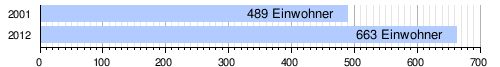
At the 2012 census, Yowaré had 663 residents who lived in 44 households. At the 2001 census, the population was 489 in 71 households.
There is a primary school in the hamlet. There is also a health center with a Center de Santé Intégré (CSI).
Individual evidence
- ↑ Carte de référence: Niger - Région de Tillabéri - Département de Torodi. (PDF) In: REACH Resource Center. March 21, 2018, accessed May 2, 2019 (French).
- ↑ Ibrahim Mamadou: La dynamique accélérée des koris de la région de Niamey et ses conséquences sur l'ensablement du fleuve Niger . Thèse de doctorat Ph.D. Université Abdou Moumouni de Niamey / Université Paris 1 Panthéon-Sorbonne, Niamey / Paris 2012, p. 127 and 135 ( researchgate.net [PDF; accessed April 20, 2019]).
- ↑ Haougui Adamou, Sarr Etienne, Balde Hamidou, Doumma Ali, Adam Toudou: Characterization of Plant-Parasitic-Nematode Communities Associated with three Species used in Hedges in Western Niger and their Susceptibility to Meloidogyne Javanica . In: Asian Journal of Agriculture and Rural Development . Vol. 3, No. 6 , 2013, p. 378 ( aessweb.com [PDF; accessed June 2, 2019]).
- ↑ Répertoire National des localites (ReNaLoc). (RAR) Institut National de la Statistique de la République du Niger, July 2014, p. 719 , accessed on 7 August 2015 (French).
- ^ Répertoire National des Communes (RENACOM). (RAR) Institut National de la Statistique de la République du Niger, accessed on November 8, 2010 (French).
- ↑ Issa Mamane Manirou: Etude diagnostique des conditions d'accès à l'eau, l'hygiène et l'assainissement dans les écoles publiques de l'arrondissement primaires communal V de la ville de Niamey, Niger . Mémoire de fin d'étude. Annexes. 2iE Institut International de l'Eau et de l'Environnement, Ouagadougou 2016, p. IV ( documentation.2ie-edu.org [PDF; accessed June 3, 2019]).
- ^ Niger DSS. In: Systems Nationale d'Information Sanitaire (SNIS). Ministère de la Santé Publique, République du Niger, accessed on June 9, 2019 (French).
Coordinates: 13 ° 28 ' N , 2 ° 1' E