
Bassignac
|
Bassignac Bassinhac |
||
|---|---|---|
|
||
| region | Auvergne-Rhône-Alpes | |
| Department | Cantal | |
| Arrondissement | Mauriac | |
| Canton | Ydes | |
| Community association | Sumène Artense | |
| Coordinates | 45 ° 19 ′ N , 2 ° 24 ′ E | |
| height | 359-671 m | |
| surface | 11.95 km 2 | |
| Residents | 231 (January 1, 2017) | |
| Population density | 19 inhabitants / km 2 | |
| Post Code | 15240 | |
| INSEE code | 15019 | |

Bassignac ( Occitan Bassinhac ) is a French municipality with 231 inhabitants (at January 1, 2017) in the department of Cantal in the region of Auvergne Rhône-Alpes (before 2016 Auvergne ); it belongs to the arrondissement of Mauriac and the canton of Ydes (until 2015 Saignes ). The inhabitants are called Bassignacois .
geography
Bassignac is located in the northwestern foothills of the Monts-du-Cantal massif, about 42 kilometers north of Aurillac on the Sumène . Bassignac is surrounded by the neighboring communities of Champagnac in the north, Ydes in the northeast, Sauvat in the east, Méallet in the south and southeast, Jaleyrac in the south and southwest and Veyrières in the west.
Population development
| year | 1962 | 1968 | 1975 | 1982 | 1990 | 1999 | 2006 | 2011 | 2016 |
| Residents | 358 | 276 | 223 | 209 | 208 | 230 | 227 | 223 | 227 |
| Source: Cassini and INSEE | |||||||||
Attractions
- Church of Sainte-Radegonde from the 11th / 12th centuries century
- Chapel of Saint Jacques in Vendès from the 12th century, monument historique since 1972
- Viaduct over the Sumène, built in 1893, Monument historique since 2006
- Castle or fortress Charlus
- Le Rieu Castle

Saint-Jacques Chapel
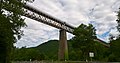
viaduct

,_viaduc_de_la_Sum%C3%A8ne.jpg)
Web links
Commons : Bassignac - collection of images, videos and audio files