
Antignac (Cantal)
|
Antignac Antinhac |
||
|---|---|---|
|
||
| region | Auvergne-Rhône-Alpes | |
| Department | Cantal | |
| Arrondissement | Mauriac | |
| Canton | Ydes | |
| Community association | Sumène Artense | |
| Coordinates | 45 ° 21 ' N , 2 ° 33' E | |
| height | 468-928 m | |
| surface | 16.02 km 2 | |
| Residents | 281 (January 1, 2017) | |
| Population density | 18 inhabitants / km 2 | |
| Post Code | 15240 | |
| INSEE code | 15008 | |
| Website | www.mairie-antignac.fr | |
 Town hall (Mairie) of Antignac |
||

Antignac ( Occitan : Antinhac ) is a French municipality with 281 inhabitants (as of January 1 2017) in the department of Cantal in the region of Auvergne Rhône-Alpes ; it belongs to the arrondissement of Mauriac and the canton of Ydes (until 2015: canton of Saignes ). The inhabitants are called Antignacois .
geography
Antignac is located in the northwestern foothills of the Monts du Cantal massif, about 47 kilometers north-northeast of Aurillac . Antignac is surrounded by the neighboring communities of Champs-sur-Tarentaine-Marchal in the north, Saint-Étienne-de-Chomeil in the east, La Monselie in the south and Vebret in the west.
Population development
| year | 1962 | 1968 | 1975 | 1982 | 1990 | 1999 | 2008 | 2013 |
| Residents | 449 | 439 | 361 | 305 | 335 | 292 | 276 | 285 |
| Source: Cassini and INSEE | ||||||||
Attractions
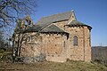
- Church of Saint-Victor (also: Church of Saint-Pierre-ès-Liens ), parts from the 12th century have been preserved, the rest from the 18th and 19th centuries. Century, since 1976 Monument historique
- Church of Saint-Étienne (also: Church of Saint-Ferréol or Notre-Dame-du-Bon-Secours chapel ) in Salsignac from the 12th century, monument historique since 1969
- Saint-Robert priory church (also: Church of Saint-Jean-Baptiste or Notre-Dame chapel ) in Le Roc-Vigonnet from the 12th century, monument historique since 1930

Saint-Victor church

Saint-Etienne church
Saint Robert Church


Web links
Commons : Antignac - collection of images, videos and audio files