
Anglards-de-Salers
|
Anglards-de-Salers Anglars de Salèrn |
||
|---|---|---|

|
|
|
| region | Auvergne-Rhône-Alpes | |
| Department | Cantal | |
| Arrondissement | Mauriac | |
| Canton | Mauriac | |
| Community association | Pays de Salers | |
| Coordinates | 45 ° 12 ′ N , 2 ° 26 ′ E | |
| height | 530-1,317 m | |
| surface | 48.36 km 2 | |
| Residents | 777 (January 1, 2017) | |
| Population density | 16 inhabitants / km 2 | |
| Post Code | 15380 | |
| INSEE code | 15006 | |
 Town hall (Mairie) of Anglards-de-Salers |
||

Anglards-de-Salers ( Occitan Anglars de Salern ) is a French municipality with 777 inhabitants (at January 1, 2017) in the department of Cantal in the region of Auvergne Rhône-Alpes (before 2016 Auvergne ); it belongs to the arrondissement of Mauriac and the canton of Mauriac (until 2015 the canton of Salers ).
geography
Anglards-de-Salers is about 31 kilometers north of Aurillac on Mars . Anglards-de-Salers is surrounded by Méallet in the north and north-west, Moussages in the north, Saint-Vincent-de-Salers in the east and north-east, Le Vaulmier in the east and south-east, Saint-Bonnet-de-Salers in the south, Salins in the west and south-west and Le Vigean to the west and north-west.
Population development
| year | 1962 | 1968 | 1975 | 1982 | 1990 | 1999 | 2006 | 2013 |
| Residents | 1,372 | 1,240 | 1,037 | 819 | 843 | 755 | 765 | 802 |
| Source: Cassini and INSEE | ||||||||
Attractions
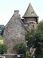
- Saint-Thyrse church from the 12th century, monument historique since 1977
- La Trémolière castle from the 15th century, monument historique since 1981
- Longevergne Castle from the 15th century, a historical monument since 2002

Saint-Thyrse church
La Trémolière Castle

Longevergne Castle


