
Saignes (Cantal)
|
Saignes Sonha |
||
|---|---|---|

|
|
|
| region | Auvergne-Rhône-Alpes | |
| Department | Cantal | |
| Arrondissement | Mauriac | |
| Canton | Ydes | |
| Community association | Sumène Artense | |
| Coordinates | 45 ° 20 ′ N , 2 ° 29 ′ E | |
| height | 442-780 m | |
| surface | 6.81 km 2 | |
| Residents | 835 (January 1, 2017) | |
| Population density | 123 inhabitants / km 2 | |
| Post Code | 15240 | |
| INSEE code | 15169 | |
| Website | www.saignes-mairie.fr | |
 Saignes Town Hall (Mairie) |
||

Saignes ( Occitan : Sonha ) is a French municipality with 835 inhabitants (as of January 1 2017) in the department of Cantal in the region of Auvergne Rhône-Alpes ; it belongs to the arrondissement of Mauriac and the canton of Ydes (until 2015: canton of Saignes ).
geography
Saignes is located in the northwestern foothills of the Monts du Cantal massif, about 46 kilometers north of Aurillac . Saignes is surrounded by the neighboring communities of Ydes in the north and west, Vebret in the east and northeast, Le Monteil in the south and southeast and Sauvat in the southwest.
Population development
| year | 1962 | 1968 | 1975 | 1982 | 1990 | 1999 | 2008 | 2013 |
| Residents | 642 | 702 | 735 | 957 | 1.009 | 1.006 | 898 | 891 |
| Source: Cassini and INSEE | ||||||||
Attractions
- Sainte-Croix church from the 12th century
- Notre-Dame chapel from the 12th century, Monument historique
- Remains of the old castle

Sainte-Croix church

Notre-Dame chapel
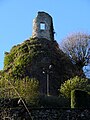
Remains of the castle


Web links
Commons : Saignes - collection of images, videos and audio files