
Ally (Cantal)
|
Ally Ali |
||
|---|---|---|
|
||
| region | Auvergne-Rhône-Alpes | |
| Department | Cantal | |
| Arrondissement | Mauriac | |
| Canton | Mauriac | |
| Community association | Pays de Salers | |
| Coordinates | 45 ° 11 ′ N , 2 ° 19 ′ E | |
| height | 471-810 m | |
| surface | 23.11 km 2 | |
| Residents | 605 (January 1, 2017) | |
| Population density | 26 inhabitants / km 2 | |
| Post Code | 15700 | |
| INSEE code | 15003 | |

Ally ( Occitan : Ali ) is a French municipality with 605 inhabitants (as of January 1 2017) in the department of Cantal in the region of Auvergne Rhône-Alpes ; it belongs to the arrondissement of Mauriac and the canton of Mauriac (until 2015 the Pleaux ). The inhabitants are called Allyçois (es) .
geography
Ally is about 18 miles north-northwest of Aurillac . The municipality is bounded in the north by the Auze and in the south by the Incon . Ally is surrounded by Mauriac in the north, Le Vigean and Escorailles in the northeast, Drugeac in the east , Sainte-Eulalie in the east, Pleaux in the south, Barriac-les-Bosquets in the southwest, Chaussenac in the west and Brageac in the northwest.
The former route nationale 680 (today's D680) runs through the municipality .
Population development
| year | 1962 | 1968 | 1975 | 1982 | 1990 | 1999 | 2006 | 2013 |
| Residents | 889 | 814 | 1.008 | 861 | 698 | 700 | 671 | 635 |
| Source: Cassini and INSEE | ||||||||
Attractions
- Saint-Ferréol church from the 12th century, monument historique since 1987
- Saint-Thibaud church from the 11th century, monument historique
- La Vigne Castle, from the 15th century with alterations from the 17th century and park, monument historique since 1991
- Windmills
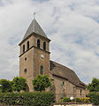
Saint-Ferréol church

La Vigne Castle
_-_Fa%C3%A7ade_Ouest-Sud.jpg)

Trivia
Jean-Jacques Rousseau lived in the La Vigne castle and visited the church of Saint-Ferréol.