Cermignano
| Cermignano | ||
|---|---|---|

|
|
|
| Country | Italy | |
| region | Abruzzo | |
| province | Teramo (TE) | |
| Coordinates | 42 ° 35 ' N , 13 ° 48' E | |
| height | 563 m slm | |
| surface | 26 km² | |
| Residents | 1,576 (Dec. 31, 2019) | |
| Population density | 61 inhabitants / km² | |
| Post Code | 64037 | |
| prefix | 0861 | |
| ISTAT number | 067016 | |
| Popular name | Cermignanesi | |
| Patron saint | New Year I (December 31st) | |
| Website | Cermignano | |
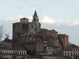
 View of Cermignano |
||
Cermignano is an Italian commune with 1576 inhabitants (as of December 31, 2019) in the province of Teramo in Abruzzo . The village is a member of the Comunità Montana del Vomano, Fino e Piomba .
geography
The districts (fractions) include Montegualtieri, Poggio delle Rose and Santa Maria.
The neighboring municipalities are: Bisenti , Canzano , Castel Castagna , Castellalto , Cellino Attanasio , Penna Sant'Andrea and Teramo .
The municipality is located around 19 kilometers from the provincial capital Teramo and 25 kilometers from the Adriatic coast.
history
The origins of the community go back to pre-Roman times. A fortified colony was established by the Sabines . In the Middle Ages, several churches and the La Torre di Montegualtieri tower were built in the village .
Population development
| year | 1861 | 1881 | 1901 | 1921 | 1936 | 1951 | 1971 | 1991 | 2001 | 2016 |
|---|---|---|---|---|---|---|---|---|---|---|
| Residents | 2,389 | 2,611 | 3,227 | 3,392 | 4.121 | 4,399 | 3,083 | 2,196 | 1,970 | 1,627 |
Source: ISTAT
Attractions
- The tower of La Torre di Montegualtieri
- The churches Chiesa parrocchiale di San Martino , Chiesa di Santa Maria ad Martyres and Chiesa di San'Eustachio
Web links
- Official website of the Municipality of Cermignano (multilingual)
- Information on the municipality of Arsita (Italian)
Individual evidence
- ↑ Statistiche demografiche ISTAT. Monthly population statistics of the Istituto Nazionale di Statistica , as of December 31 of 2019.

