
Tortoreto
| Tortoreto | ||
|---|---|---|

|
|
|
| Country | Italy | |
| region | Abruzzo | |
| province | Teramo (TE) | |
| Coordinates | 42 ° 48 ' N , 13 ° 55' E | |
| height | 239 m slm | |
| surface | 23 km² | |
| Residents | 12,004 (Dec. 31, 2019) | |
| Population density | 522 inhabitants / km² | |
| Post Code | 64018 | |
| prefix | 0861 | |
| ISTAT number | 067044 | |
| Popular name | Tortoretani | |
| Patron saint | San Nicola di Bari (December 6th) | |
| Website | Tortoreto | |
 View of Tortoreto Lido |
||

Tortoreto is an Italian commune with 12,004 inhabitants (as of December 31, 2019) in the province of Teramo in the Abruzzo region .
geography
The districts (fractions) include Tortoreto Alto, Tortoreto Lido, Cavatassi, Salino and Terrabianca.
The neighboring municipalities are: Alba Adriatica , Corropoli , Giulianova , Mosciano Sant'Angelo and Sant'Omero .
Tortoreto is around 43 km from the provincial capital Teramo and 4 km from the Adriatic coast. The Salino district is traversed by the Salinello river. The municipality is well connected to the Strada Statale 16 Adriatica , A14 and the European route 55 .
history
In the area of the two municipalities of Corropoli and Tortoreto, excavations discovered several remains of villages and huts from the Bronze Age. The settlement of Castrum Salina was built in Roman times . In the Middle Ages, numerous churches were built in the area. In the 16th century the village was under Spanish rule, later the Kingdom of Naples took possession of the settlement. Around 1800, while Napoleon Bonaparte was conquering Italy and large parts of Europe, Tortoreto also fell into French hands. The French looted the community, damaged the churches and stole important works of art and documents.
After Italy entered the war in June 1940, the fascist regime established an internment camp in Tortoreto ( campo di concentramento or campo per l'internamento civile ). It consisted of a centrally located private house - the Casa De Fabritiis - and a secluded country house - the Casa Tonelli - which together could accommodate 100 internees. In September 1940 there were 103, in August 1942 114 inmates in Tortoreto, mostly foreign Jews , members of the Slavic minorities in the Italian border provinces and Yugoslavs from the areas occupied and annexed by Italy. The sanitary conditions and the drinking water supply left a lot to be desired. In May 1943 the internees were distributed to other camps.
A former intern, Saul Steinberg , emigrated to the United States after the war and made a name for himself as a cartoonist and illustrator with the New Yorkers .
During the Second World War, Tortoreto Lido and the train station in Tortoreto were almost completely destroyed.
In 1956 the municipality was divided and Alba Adriatica , which previously belonged to Tortoreto, was spun off as an independent municipality.
Population development
| year | 1861 | 1881 | 1901 | 1921 | 1936 | 1951 | 1971 | 1991 | 2001 | 2016 |
|---|---|---|---|---|---|---|---|---|---|---|
| Residents | 2,541 | 3,805 | 4,236 | 5,082 | 4,493 | 4,647 | 4,889 | 7,040 | 7,836 | 11,622 |
Source: ISTAT
Attractions
- The churches of Chiesa parrocchiale di San Nicola and Chiesa di Sant'Agostino

Tortoreto clock tower

Chiesa di Sant'Agostino

Siren statue in Tortoreto Lido

Park in the Tortoreto Lido district
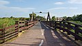
Bridge over the Salinello River


economy
Tortoreto's economy is heavily dependent on tourism in summer. The nearby Adriatic coast is a popular seaside resort. Other important factors for the local economy are coastal fishing, the industrial park in the center, furniture and metal factories and the hospitality industry .
In the municipality of vines are varieties Montepulciano for the DOC - wine Montepulciano d'Abruzzo grown.
Web links
- Official website of the Municipality of Tortoreto (Italian)
- Information on the municipality of Tortoreto (Italian)
Individual evidence
- ↑ Statistiche demografiche ISTAT. Monthly population statistics of the Istituto Nazionale di Statistica , as of December 31 of 2019.
- ↑ Carlo Spartaco Capogreco, I Campi del duce. L'internamento civile nell'Italia fascista (1940-1943) , Torino 2004 (Einaudi), pp. 222-223; Klaus Voigt, Refuge on Revocation. Exile in Italy 1933–1945 (Volume 2), Stuttgart 1993 (Klett-Cotta), pp. 67–68 >>

Alba Adriatica | Ancarano | Arsita | Atri | Basciano | Bellante | Bisenti | Campli | Canzano | Castel Castagna | Castellalto | Castelli | Castiglione knife Raimondo | Castilenti | Cellino Attanasio | Cermignano | Civitella del Tronto | Colledara | Colonnella | Controguerra | Corropoli | Cortino | Crognaleto | Fano Adriano | Giulianova | Isola del Gran Sasso d'Italia | Martinsicuro | Montefino | Montorio al Vomano | Morro d'Oro | Mosciano Sant'Angelo | Nereto | Notaresco | Penna Sant'Andrea | Pietracamela | Pineto | Rocca Santa Maria | Roseto degli Abruzzi | Sant'Egidio alla Vibrata | Sant'Omero | Silvi | Teramo | Torano Nuovo | Torricella Sicura | Tortoreto | Tossicia | Valle Castellana