Cruzeiro do Sul (Acre)
| Município de Cruzeiro do Sul "Cruzeiro", "Capital do Vale do Juruá", "Terra dos Náuas", "Capital do Interior do Acre"
Cruzeiro do Sul
|
|||
|---|---|---|---|
|
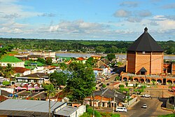
Center with the Cathedral of Nossa Senhora da Glória
|
|||
|
|
|||
| Coordinates | 7 ° 38 ′ S , 72 ° 40 ′ W | ||
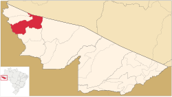
 Location of Cruzeiro in the state of Acre Location of Cruzeiro in the state of Acre
|
|||
| Symbols | |||
|
|||
| founding | September 28, 1904 | ||
| Basic data | |||
| Country | Brazil | ||
| State | acre | ||
| ISO 3166-2 | BR-AC | ||
| Região intermediária | Cruzeiro do Sul (since 2017) | ||
| Região imediata | Cruzeiro do Sul (since 2017) | ||
| Mesoregion | Vale do Juruá (1989-2017) | ||
| Microregion | Cruzeiro do Sul (1989-2017) | ||
| height | 182 m | ||
| surface | 8,779.4 km² | ||
| Residents | 78,507 (2010) | ||
| density | 8.9 Ew. / km² | ||
| estimate | 88,376 Ew. (July 1, 2019) | ||
| Parish code | IBGE : 1200203 | ||
| Time zone | UTC -5 | ||
| Website | www.cruzeirodosul.ac.gov.br (Brazilian Portuguese) | ||
| politics | |||
| City Prefect | Ilderlei Cordeiro (2017-2020) | ||
| Political party | (PMDB) | ||
| economy | |||
| GDP | 1,062,505 thousand R $ 13,034 R $ per capita (2015) |
||
| HDI | 0.664 (2010) | ||
|
Federal highway BR-364
|
|||
Cruzeiro do Sul , officially Município de Cruzeiro do Sul , is a medium-sized town in the Brazilian state of Acre . It is the second largest city after the capital Rio Branco, 632 km away .
history
Until 1903 the area belonged to Bolivia and only became Brazilian territory through the Treaty of Petrópolis between Bolivia and Brazil , signed on November 17, 1903 . The establishment as Vila de Cruzeiro do Sul followed on September 28, 1904. In the southwest it is border area with Peru .
population
The population was according to the census of the IBGE of 2010 78.507 inhabitants . The number was estimated by the IBGE as of July 1, 2019 at 88,376 residents.
Population development
Source IBGE (figure for 2019 is only an estimate)

economy
Development of the gross national product for the years 2003 to 2015 in thousands of R $ :

Infrastructure
Cruzeiro do Sul is located on the BR-364 national road and has the international airport Aeroporto Internacional de Cruzeiro do Sul (IATA: CZS ; ICAO: SBCZ ), which also serves the cities of Rodrigues Alves and Mâncio Lima in Acre and the city of Guajará in the state Amazon serves.
Terras indígenas
Two Indian reservations have been set up in the municipality, populated by Yaminawás and Katukinas , who belong to the Pano language families . In particular, the Katukinas are affected by the BR-364, which runs through the middle of their settlement area.
Web links
- City Prefecture website (Portuguese)
Individual evidence
- ↑ a b IBGE : Cidades Acre: Cruzeiro do Sul - Panorama. Retrieved September 29, 2018 (Brazilian Portuguese).
- ↑ a b IBGE : Estimativas da população residente no Brasil e unidades da federação com data de referência em 1 ° de julho de 2019. (PDF) Retrieved on September 10, 2019 (Brazilian Portuguese).
- ↑ IBGE: Cruzeiro do Sul - História. Retrieved September 29, 2018 (Brazilian Portuguese).
- ↑ IBGE : Cruzeiro do Sul - Pesquisas - Produto Interno Bruto dos Municípios. In: gov.br. Retrieved September 29, 2018 (Brazilian Portuguese).
- ↑ Yaminawá on the website Povos Indígenas no Brasil , Instituto Socioambiental (Portuguese, English).
- ↑ Katukina Pano on the website Povos Indígenas no Brasil , Instituto Socioambiental (Portuguese, English).
- ↑ Cruzeiro do Sul on the Novo Acre website , Portal do Governo do Acre. (Enter location as search term; Portuguese; accessed September 25, 2015).


