Culfa (Rayon)

from Wikipedia, the free encyclopedia
Şəki Abşeron Sumqayıt Baku Xızı Siyəzən Quba Quba Şabran Xaçmaz Qusar Qobustan Şirvan Hacıqabul Salyan Neftçala Lənkəran Lənkəran Astara (Rayon) Lerik (Rayon) Yardımlı (Rayon) Cəlilabad (Rayon) Masallı (Rayon) Biləsuvar (Rayon) Sabirabad (Rayon) Saatlı İmişli (Rayon) Kürdəmir (Rayon) Şamaxı (Rayon) Ağsu (Rayon) Göyçay (Rayon) Ucar (Rayon) Beyləqan (Rayon) Ağcabədi (Rayon) Bərdə (Rayon) Zərdab (Rayon) İsmayıllı (Rayon) Qəbələ (Rayon) Ağdaş Yevlax (Stadt) Mingəçevir Yevlax (Rayon) Naftalan Göygöl (Rayon) Gədəbəy (Rayon) Samux (Rayon) Gəncə Şəmkir (Rayon) Tovuz (Rayon) Ağstafa (Rayon) Qazax (Rayon) Oğuz (Rayon) Şəki (Rayon) Qax (Rayon) Zaqatala (Rayon) Balakən (Rayon) Şəmkir (Rayon) Goranboy (Teile de-facto Republik Bergkarabach) Daskesan (Teile de-facto Republik Bergkarabach) Terter (Teile de-facto Republik Bergkarabach) Agdam (Teile de-facto Republik Bergkarabach) Xocavend (Teile de-facto Republik Bergkarabach) Füzuli (Teile de-facto Republik Bergkarabach) Kelbecer (fast vollständig de-facto Republik Bergkarabach) Xankəndi (unter der Bezeichnung „Stepanakert“ de-facto Teil der Republik Bergkarabach) Cabrayil (de-facto Republik Bergkarabach) Xocali (de-facto Republik Bergkarabach) Susa (de-facto Republik Bergkarabach) Lacin (de-facto Republik Bergkarabach) Qubadli (de-facto Republik Bergkarabach) Zengilan (de-facto Republik Bergkarabach) Ordubad (Teil der Autonomen Republik Nachitschewan) Culfa (Teil der Autonomen Republik Nachitschewan) Naxcivan (Teil der Autonomen Republik Nachitschewan) Babek (Teil der Autonomen Republik Nachitschewan) Sahbuz (Teil der Autonomen Republik Nachitschewan) Kangarli (Teil der Autonomen Republik Nachitschewan) Serur (Teil der Autonomen Republik Nachitschewan) Saderak (Teil der Autonomen Republik Nachitschewan)
Location of the Culfa Rayon in Azerbaijan

Culfa even Julfa , one is rayon in Azerbaijan in the Autonomous Republic of Nakhichevan . The capital has the same name .

geography

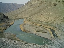
River Aras on the border with Iran in the Culfa Rayon.

The district covers an area of 993 and is bordered to the north by Armenia , in the south with the river Aras (flow) to the Iran . In the mountainous region there are deposits of silver , gypsum and building materials as well as mineral water springs.

population

In 2009 there were 41,000 residents in the district. These are spread over 25 settlements.

economy

The district is dominated by agriculture. Mainly wine and grain are grown and cattle are raised . There are also several manufacturing companies

Architectural monuments

There are several mausoleums in the district, the İlandağ old tower and Alindja fortress . Bridges from the 12th century lead over the macaws. The Amenaprkich Monastery is located near the town of Culfa. The rock inscription from Ojasar-İlandağ comes from the Urartian ruler Išpuini .

The Armenian cemetery Culfa , world heritage from the 17th century, was destroyed of 2006.

Individual evidence

  1. a b c d Azerbaijan Development Gateway ( Memento of November 14, 2008 in the Internet Archive ) about the rayon
  2. a b azerb.com about the district
  3. Azerbaijani Statistical Authority ( Memento of November 14, 2010 in the Internet Archive )
  4. ^ M. Salvini, A Urartean rock inscription in the Nachičevan region. Journal of Assyriology and Near Eastern Archeology 88/1, 94–99

Web links

Commons : Julfa Rayon  - Collection of images, videos and audio files

Coordinates: 39 ° 0 '  N , 45 ° 40'  E