Samux (Rayon)

from Wikipedia, the free encyclopedia
Şəki Abşeron Sumqayıt Baku Xızı Siyəzən Quba Quba Şabran Xaçmaz Qusar Qobustan Şirvan Hacıqabul Salyan Neftçala Lənkəran Lənkəran Astara (Rayon) Lerik (Rayon) Yardımlı (Rayon) Cəlilabad (Rayon) Masallı (Rayon) Biləsuvar (Rayon) Sabirabad (Rayon) Saatlı İmişli (Rayon) Kürdəmir (Rayon) Şamaxı (Rayon) Ağsu (Rayon) Göyçay (Rayon) Ucar (Rayon) Beyləqan (Rayon) Ağcabədi (Rayon) Bərdə (Rayon) Zərdab (Rayon) İsmayıllı (Rayon) Qəbələ (Rayon) Ağdaş Yevlax (Stadt) Mingəçevir Yevlax (Rayon) Naftalan Göygöl (Rayon) Gədəbəy (Rayon) Samux (Rayon) Gəncə Şəmkir (Rayon) Tovuz (Rayon) Ağstafa (Rayon) Qazax (Rayon) Oğuz (Rayon) Şəki (Rayon) Qax (Rayon) Zaqatala (Rayon) Balakən (Rayon) Şəmkir (Rayon) Goranboy (Teile de-facto Republik Bergkarabach) Daskesan (Teile de-facto Republik Bergkarabach) Terter (Teile de-facto Republik Bergkarabach) Agdam (Teile de-facto Republik Bergkarabach) Xocavend (Teile de-facto Republik Bergkarabach) Füzuli (Teile de-facto Republik Bergkarabach) Kelbecer (fast vollständig de-facto Republik Bergkarabach) Xankəndi (unter der Bezeichnung „Stepanakert“ de-facto Teil der Republik Bergkarabach) Cabrayil (de-facto Republik Bergkarabach) Xocali (de-facto Republik Bergkarabach) Susa (de-facto Republik Bergkarabach) Lacin (de-facto Republik Bergkarabach) Qubadli (de-facto Republik Bergkarabach) Zengilan (de-facto Republik Bergkarabach) Ordubad (Teil der Autonomen Republik Nachitschewan) Culfa (Teil der Autonomen Republik Nachitschewan) Naxcivan (Teil der Autonomen Republik Nachitschewan) Babek (Teil der Autonomen Republik Nachitschewan) Sahbuz (Teil der Autonomen Republik Nachitschewan) Kangarli (Teil der Autonomen Republik Nachitschewan) Serur (Teil der Autonomen Republik Nachitschewan) Saderak (Teil der Autonomen Republik Nachitschewan)
Location of Samux Rayon in Azerbaijan

Samux is a rayon in Azerbaijan . The capital of the district is the city Samux that until 13 June 2008 Nəbiağalı said. The name comes from the Caucasian-Albanian word for place of hunting in the forest .

geography

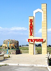
Welcome sign of the district

The district has an area of ​​1210 km². The Kura , Qabırrı , Ganikh and Gusgara rivers flow through the rayon . It is partially forested, with oak and pine forests being predominant.

population

In 2009, 53,400 people lived in 29 settlements in the rayon.

economy

The economy is dominated by agriculture. Above all, fruit, vegetables and wine are grown and cattle is raised.

Individual evidence

  1. ^ Azerbaijan Guidebook (fourth edition). 2007, AzerOlympicInternational Publishing House, p. 262
  2. a b c Azerbaijan Developement Gateway ( Memento of November 14, 2008 in the Internet Archive ) about the rayon and the city
  3. Azerbaijani statistical office on population figures ( Memento of November 14, 2010 in the Internet Archive )

Web links

Commons : Samukh Rayon  - Collection of Images, Videos and Audio Files

Coordinates: 40 ° 50 ′  N , 46 ° 30 ′  E