Forest box
The Forst Kasten is a foundation forest owned by the City of Munich . The forest is also known as the Heiliggeistwald .
geography

The approx. 800 hectare wooded area borders on Stockdorf to the east and Krailling , Planegg and Neuried to the south and lies north of Buchendorf . The forest is part of the Forstenrieder Park landscape protection area and is part of the Munich green belt . The Stockdorfer Kastenfeld , which was located between the Kraillinger Feld and the Grubmühl field, was named after the forest until the 19th century .
The forest is managed by the forest administration of the state capital Munich (municipal department), Weyarn -Gotzing.
The Forsthaus Kasten belongs to the municipality of Neuried (as an inhabited district), as does most of the forest. The remaining parts of the forest belong to the communities of Planegg and Gauting.
history
In the forest of Kasten there are numerous barrows , some from the Hallstatt period , which give an indication of the early settlement.
The name Kasten , originally Castell , may be derived from the nearby Roman camp, which was located on the Via Julia .
It was first mentioned in a document in 1308, when part of today's forest area was sold to the Heilig-Geist-Spital in Munich by the Andechs ministerial Heinrich von Smiechen . In the following decades a Schwaige developed to manage the forest. From 1715 to 1745 the forest was part of the electoral Bavarian deer hunting park . In the course of the 19th century, similar to the Kreuzlinger Forst, the management began to be converted from the original beech and then oak to spruce cultures. Since around 1990, the alien, storm-prone and pest-prone spruce monocultures have been converted back into economically and ecologically valuable mixed forests by the responsible foresters. This is done by planting various mixed tree species and protecting them from roe deer bites that threaten the very existence of deer by hunted. Until 1884, Forst Kasten was part of the royal court hunting area.
From 1899 onwards, snacks were sold to hikers in the forester's house, from which the beer garden that exists today developed. Shortly before the hundredth anniversary of forestry in 1998, a fire broke out from the roof structure, which required extensive restoration and renovation, which was carried out by Adolf Schindhelm, lasted from 2000 to 2002 and cost almost 2.5 million euros. Today the forester's house belongs to the Heiliggeistspital Foundation.
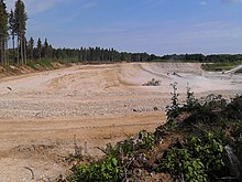
At the beginning of the 1970s, two gravel pits of different sizes from the Bernhard Glück company from Graefelfing in the forest of Kasten started operations. The smaller gravel pit was located west of Neuried in the middle of the forest ( location ) and was manned with a dragline excavator and at times also with a wheel loader . The second, much larger gravel pit, on the other hand, was opened south of Planegg at the edge of the forest ( location ). Since then, the gravel has been mined there with wheel loaders and transported by conveyor belt to the gravel works near Graefelfing, around 2.5 kilometers away.
The community-free area Forst Kasten in the district of Munich with an area of originally 598.03 and most recently 590.28 hectares existed until December 31, 2001. With effect from January 1, 2002 it was between the communities Neuried (459.64 hectares) and Planegg (130.64 hectares) divided. The Forsthaus Kasten was not part of the community-free area, but belonged as an exclave to the Neuried community ( parcel 342 of the Neuried district , a little more than 0.4 hectares).
Web links
Individual evidence
- ↑ https://www.muenchen.de/rathaus/Stadtverwaltung/Kommunalreferat/forstverwaltung.html
- ^ Karl Mayr: Gauting and Stockdorf. 1870-1988. Deutscher Kunstverlag, Munich 1985.
- ↑ Wilhelm Weissbecker, Katya Shchedrova: Jahrbuch Baumaschinen 2020. Podszun-Verlag, 2019, ISBN 978-3-86133-934-2 , page 63 ff.
- ^ Resolution of the government of Upper Bavaria of September 18, 2001
Coordinates: 48 ° 4 '32.1 " N , 11 ° 24' 59.59" O


