Feldkirchen (District of Munich)
| coat of arms | Germany map | |
|---|---|---|

|
Coordinates: 48 ° 9 ' N , 11 ° 44' E |
|
| Basic data | ||
| State : | Bavaria | |
| Administrative region : | Upper Bavaria | |
| County : | Munich | |
| Height : | 523 m above sea level NHN | |
| Area : | 6.41 km 2 | |
| Residents: | 7552 (Dec. 31, 2019) | |
| Population density : | 1178 inhabitants per km 2 | |
| Postal code : | 85622 | |
| Area code : | 089 | |
| License plate : | M , AIB , WOR | |
| Community key : | 09 1 84 118 | |
| LOCODE : | DE FKM | |
| Address of the municipal administration: |
Rathausplatz 1 85622 Feldkirchen |
|
| Website : | ||
| Mayor : | Andreas Janson (UWV) | |
| Location of the community Feldkirchen in the district of Munich | ||
Feldkirchen is a municipality in the Upper Bavarian district of Munich , directly at the former Munich-Riem Airport . In recent years the community has developed from a place with a village structure to a suburban community.
Community structure
There are no officially designated parts of the municipality for the municipality. The residential area at "Dornacher Feld" is an additional voting district.
history
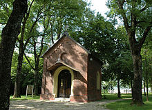
The first written mention of Feldkirchen together with a chapel goes back to the year 853. The chapel is dedicated to St. Bishop Emmeram , who died near Feldkirchen in the second half of the 7th century. Feldkirchen was later assigned to the Munich Rent Office and the Wolfratshausen Regional Court of the Electorate of Bavaria . In the course of the administrative reforms in Bavaria , today's municipality was created with the municipal edict of 1818 .
After the so-called "Überrheiner" (especially from the Palatinate and Baden ) settled in Feldkirchen, one of the first Protestant parishes in the Munich area was founded in 1833. This parish later became the mother parish of a number of other evangelical parishes in the area.
With the opening of the Munich – Neuötting railway on May 1, 1871, Feldkirchen received its own train station . The Feldkirchen – Abzw Nordost freight line (near Johanneskirchen ), which went into operation on January 1, 1942, was shut down and dismantled in 1949. The original route is now under protection in the form of a biotope approximately three kilometers in length.
After the quarrying of gravel at the quarry pond on the eastern municipality boundary , the Heimstettener See was built in 1937 , which is now used as a swimming lake and local recreation area.
With the construction of the nearby A 99 and A 94 autobahns with the “Feldkirchen Ost” and “Feldkirchen West” autobahn connections, the supraregional connection of the town was significantly expanded.
The closure of the neighboring former Munich-Riem airport in 1992 led to a better quality of life for the residents. In the years that followed, the Munich district Messestadt Riem with the Riem Arcaden shopping center and the Riemer Park landscape park were built on the airport grounds .
Feldkirchen started a future project in 2008 together with the communities of Aschheim and Kirchheim . Geothermal energy is distributed to the communities via a district heating network and reduces dependence on fossil raw materials. After the first borehole in 2008, the first households were connected in 2009.
Population development
Between 1988 and 2018 the community grew from 3,375 to 7,526 by 4,151 inhabitants or 123% - the second highest percentage increase in population after Unterföhring in the district in the period mentioned.
Name origin
The historical role of Feldkirch as one of the first Protestant parishes in the region is often wrongly interpreted as the origin of the name in the assumption that Protestants who were not tolerated in Munich were forced to build their church outside the city ("on the field"). However, this is wrong for several reasons. Firstly, the Feldkirchen Protestants did not come from Munich, but from areas on the left bank of the Rhine; secondly, the community used to be far too far from the outskirts of Munich to serve as an alternative point for a church, thirdly, there was no such eviction of Protestants in Munich, and fourthly, Feldkirchen already existed under this name long before a Protestant denomination even emerged. Only the derivation of the “church on the field” is correct, but this referred to the chapel for St. Emmeram that was built near the old salt road .
religion
The parish of the evangelical parish of Feldkirchen currently includes the political parishes of Feldkirchen and Aschheim as well as those districts of the parish of Vaterstetten that formed the parish of Parsdorf until 1978 (Hergolding, Neufarn , Parsdorf, Purfing and Weißenfeld ). It was founded in 1833 as the first Protestant congregation in the Munich area and therefore gained regional importance. The mother parish in Feldkirchen organized the first lessons and services from 1918 in Dorfen , 1920 in Grafing , 1921 in Erding , 1937 in Aschheim, Parsdorf , Poing , Markt Schwaben , Vaterstetten and Riem and in 1971 in Kirchheim near Munich .
After one of King I. Ludwig (Bayern) for the entire Kingdom of Bavaria approved fund raising in 1840 immediately after the municipal border to church today Kirchheim (district Heimstetten) in today's St. Emmeram Memorial Grove built St. Emmeram Memorial Chapel was inaugurated in 1843 and renovated between 1978 and 1983.
In addition to the Protestant and Catholic parishes, there is also the Gospel Life Center (a Christian free church ) in Feldkirchen .
politics
City council and mayor
The municipal council consists of 20 members. After the local elections on March 15, 2020 , the seats are distributed as follows:
| Party / group | Seats | G / V | Share of votes |
|---|---|---|---|
| CSU | 5 | ± 0 | 27.2% |
| SPD | 5 | - 2nd | 22.9% |
| Green | 4th | + 2 | 19.2% |
| UWV * | 6th | ± 0 | 30.7% |
* Independent electoral association
Andreas Janson (UWV) was elected mayor in a runoff election on March 29, 2020 with 58.8% of the vote.
Community partnerships
Feldkirchen maintains the Saxon community Rietschen and the Italian municipality of Bisignano community partnerships .
coat of arms
The current coat of arms of the municipality goes back to a municipal council resolution of February 4, 1970, in which the meaning of the heraldic elements is explained.
Description : Split by blue and silver; to the left, above a lowered silver oblique left-hand bar, a golden shell; on the right a blue sphere from which a blue cross rises.
The sloping left-hand bar represents the old traffic route, the Salt Road , leading through Feldkirchen . The scallop shell symbolizes the Catholic parish of St.Jakob d. J .; the blue ball of the cross symbolizes the particularly old Protestant parish in Feldkirchen.
economy
There are several commercial areas that have grown noticeably in recent years thanks to their proximity to the New Munich Trade Fair Center . Medical technology companies in particular have settled here, such as Hitachi , Schiller or Pulsion . Other well-known companies such as Tesla , Intel , T-Systems and Cadence are also represented in Feldkirchen .
Infrastructure
Road traffic
Feldkirchen is conveniently located directly on the A 94 and A 99 motorways and the B 471, which bypasses Munich in a semicircle .
railroad
The double- track Munich – Simbach railway line, electrified to Markt Schwaben , runs through the community . On the line, on the northern edge of the Feldkirchen area, is the Feldkirchen station (near Munich) , which was put into operation on May 1, 1871 by the Royal Bavarian State Railways . Feldkirchen station has been a station of the Munich S-Bahn since 1972 and has been integrated into the Munich transport and tariff network. It is served every 20 minutes by S-Bahn trains on the S 2 line from Petershausen and Altomünster via Munich to Markt Schwaben and Erding .
Bus transport
There are regional bus connections to many neighboring communities, including Aschheim , Haar and Kirchheim . The bus line 263, which runs every hour from Monday to Friday, provides a connection with the neighboring towns of Aschheim and Kirchheim near Munich as well as with the train stations Heimstetten, Feldkirchen, Munich-Riem and the underground station Messestadt West . There are also three other bus routes in the Feldkirchen municipality.
Buildings
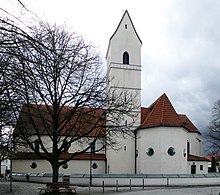
The Catholic parish church of St. James the Elder (Feldkirchen) was built in 1927 on the site of a late Gothic predecessor building, of which the former choir and bell tower are still preserved.
The Evangelical Lutheran Church was built in 1837 as a neo-Romanesque building with a retracted apse and massive roof turret.
On the edge of the community, the St. Emmeram chapel commemorates the death of St. Emmeram in 652 at this point.
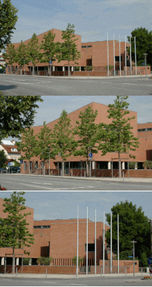
The town hall of Feldkirchen is a modern brick building in which two L-shaped individual buildings enclose a central entrance hall.
The station building, which was opened in 1871, is a two-story brick building with a flat hipped roof.
societies
The TSV Feldkirchen plays in the soccer A-Class - Group 6 Kreis München (season 2015/16). There are currently two men's teams.
The Bavarian State Hunting Association also maintains its headquarters in Feldkirchen.
The Feldkirchner brass band has been providing music since 1964.
Personalities
- Painter, artist and mayor of Feldkirchen (CSU), Konrad Schmid-Meil
- Feldkirchen was the home of the Bavarian folk actress and director Ruth Drexel , together with her partner, the folk actor Hans Brenner, who died in 1998 . Drexel died on February 26, 2009 and was buried on March 2, 2009 in Feldkirchen. The actor Gunnar Möller used to live in the same house ( I often think of Piroschka ).
literature
- Cornelia Baumann: Chronicle of the community Feldkirchen near Munich. Municipality, Feldkirchen 1990.
Others
Trivia: The border point of the communities of Haar, Feldkirchen and Munich is marked on the rest of the runway in Muenchen-Riem.
Web links
- Feldkirchen municipality
- Feldkirchen (District of Munich): Official statistics of the LfStat (PDF; 1.66 MB)
Individual evidence
- ↑ "Data 2" sheet, Statistical Report A1200C 202041 Population of the municipalities, districts and administrative districts 1st quarter 2020 (population based on the 2011 census) ( help ).
- ^ Municipal Council> Members. Feldkirchen municipality, accessed on June 29, 2020 .
- ^ The community at www.evangelisch-feldkirchen-aschheim.de Retrieved on October 13, 2017
- ↑ Fritz Lutz , St. Emmeram near Munich-Oberföhring, a former pilgrimage and school ceremonial, self-published no year (approx. 1992), p. 167 f.
- ↑ Feldkirchen municipal council elections. Retrieved May 23, 2020 .
- ^ Entry on the coat of arms of Feldkirchen (district of Munich) in the database of the House of Bavarian History
- ↑ Reinhard Wanka, Wolfgang Wiesner: The main line Munich-Simbach and its branch lines . Bufe-Fachbuch-Verlag, Egglham 1996, ISBN 3-922138-59-4 , p. 10 .
- ↑ Line network from the district of Munich (PDF; 727 kB) In: mvv-muenchen.de . Munich Transport and Tariff Association. Archived from the original on May 12, 2013. Info: The archive link was inserted automatically and has not yet been checked. Please check the original and archive link according to the instructions and then remove this notice. Retrieved April 1, 2013.
- ↑ Football on site - TSV Feldkirchen
- ↑ Riemer Forest. Retrieved March 10, 2019 .


