
Altomünster
| coat of arms | Germany map | |
|---|---|---|

|
Coordinates: 48 ° 23 ' N , 11 ° 15' E |
|
| Basic data | ||
| State : | Bavaria | |
| Administrative region : | Upper Bavaria | |
| County : | Dachau | |
| Height : | 518 m above sea level NHN | |
| Area : | 75.66 km 2 | |
| Residents: | 7960 (Dec. 31, 2019) | |
| Population density : | 105 inhabitants per km 2 | |
| Postal code : | 85250 | |
| Area code : | 08254 | |
| License plate : | DAH | |
| Community key : | 09 1 74 111 | |
| LOCODE : | DE AMN | |
| Market structure: | 47 parts of the community | |
Market administration address : |
St. Altohof 1 85250 Altomünster |
|
| Website : | ||
| First Mayor : | Michael Reiter (FWG) | |
| Location of the Altomünster market in the Dachau district | ||
  |
||


Altomünster is a market in the Upper Bavarian district of Dachau .
The name of the place is derived from the founder of the place, the holy Alto , and from the Latin word monasterium (Münster) for monastery.
geography
location
The Altomünster market is located about 20 kilometers northwest of Dachau and is the end point of the railway line going from there. It is also almost in the middle of the triangle between Munich , Augsburg and Ingolstadt .
The place is on the district road DAH 2.
The Angerbach, which is called Stumpfenbach in Stumpfenbach and flows into the Zeitlbach, flows through Altomünster .
Community structure
There are 47 officially named parts of the municipality (the type of settlement is given in brackets ):
|
|
|
|
The wasteland of Erlau belongs to the municipality of Stumpfenbach and is not an officially named municipality.
history
.jpg)
Until the church is planted
Around 750 a wandering monk named Alto settled as a hermit in what is now the local area and was given the nearby forest by the Frankish King Pipin, which is still called "Altowald" today. After his cell, Alto founded a small monastery whose church is said to have been consecrated by St. Boniface . The name "Altomünster" arose from the two names "Alto" (Holy Alto) and "Münster" (former name for monastery).
Before 1000 the Guelphs built a Benedictine monastery. In 1056, Duke Welf IV appointed the monks to settle the newly founded Weingarten Monastery in Altdorf (today Weingarten ), while the nuns previously resident in Altdorf came to Altomünster. They lived there until the monastery was dissolved by Pope Innocent VIII in 1488 .
Around 1310, the Wittelsbach dukes granted the residents citizenship . On October 4, 1391, the market and town rights were confirmed by Duke Stephan III . The Ingolstadt dukes laid out the market square around 1420.
In 1496, Duke Georg der Rich von Landshut, together with his wife Hedwig of Poland, gave the Birgitten von Maihingen a deed of foundation for Altomünster in order to found a Birgitten monastery there.
The monastery and parish church was built from 1763 to 1773 by Johann Michael Fischer . Jakob Rauch created the stucco work, Josef Mages the frescoes and altarpieces, Johann Baptist Straub and Ignaz Baldauf the altarpieces.
On March 18, 1803, the monastery was dissolved. After the secularization of 1803, the monastery was rebuilt by King Ludwig I in 1841. It was the last monastery of the old branch of the Order of the Redeemer in Germany until January 2017 .
19th and 20th centuries
From 1823 Altomünster sank to a rural community with market rights. The main reasons for this were the closure of the monastery (1803), the original main employer, and the administrative costs. A hospital was built in 1862 and a kindergarten in 1869. The Marktsparkasse was founded in 1882. In 1888 Altomünster was connected to the telegraph service , and in 1902 to the telephone service . 1907-1910 the place was electrified. On December 18, 1913, the Dachau – Altomünster local railway was opened.
Ludwig Thoma had his hunt in Altomünster and therefore often stayed here. He was close friends with the sculptor Ignaz Taschner, who also spent a lot of time in the market.
A decisive date at the end of the Second World War in Altomünster is April 26, 1945 with an air raid on the train station. The US Army moved in on April 28, 1945. In the months and years that followed, the population structure of Altomünster changed significantly, not least because many refugees and displaced persons moved into the community.
In the course of the regional reform in Bavaria , the district of Dachau was enlarged on July 1, 1972. One of the communities that was added from the dissolved Aichach district was Altomünster.
In 1977 a new school center was inaugurated.
In 1991 the double jubilee, the “600-year canonization of St. Birgitta ”and“ 600 Years of City and Market Rights ”. At the same time, the Altomünster community center was established on Steinbergstrasse in 1991 for the Protestant population.
The “Spider” disco burned down on December 1, 1996 - three days after the conviction of the managing director and “ disco mafia accomplice” Karlheinz S. Since then, Spider revival parties have taken place in Altomünster again and again.
In 1997 there was a 500-year celebration, which was crowned with the opening of the Altomünster Museum as the Birgitten and Monastery Museum. In 2003 the citizens commemorated the birth of the saint 700 years ago. In 2009, "Historical Brewers' Days" commemorated the guild regulations for the Altomünster breweries, which were ratified in 1658.
panorama

Incorporations
| local community | Residents (1970) |
Incorporation date |
Remarks |
|---|---|---|---|
| Thalhausen | 243 | 05/01/1978 | |
| Wollomoos | 478 | 05/01/1978 | |
| Pipinsried | 444 | 05/01/1978 | Incorporation of 351 of the 444 residents, reclassification of the other residents to Markt Indersdorf |
| Hohenzell | 435 | 05/01/1978 | |
| Kiemertshofen | 146 | 01/01/1977 | |
| Oberzeitlbach | 493 | 01/01/1976 | |
| Randelsried | 349 | 01/01/1976 | Incorporation of 300 of the 349 inhabitants, reclassification of the other inhabitants to Tandern |
| Stumpfenbach | 191 | 01/01/1972 |
Population development
Between 1988 and 2018 the market grew from 5,657 to 7,925 by 2,268 inhabitants or 40.1%.
politics

Municipal council
The Altomünster municipal council is composed of 20 elected, voluntary councilors. He is called "market council".
The first mayor of the market is also entitled to vote, whose vote decides in the event of a tie.
The local elections on March 16, 2014 led to the following result:
| Party / list | Seats |
| CSU | 9 |
| SPD | 1 |
| FWG | 10 |
| total | 20th |
mayor
From 1990 to 2014 Konrad Wagner from the Altomünster Free Voting Association was Mayor of Altomünster. In 2014 Konrad Wagner retired and Anton Kerle was elected as his successor with 59.5% of the valid votes.
coat of arms
The description of the coat of arms reads: In blue the growing, golden nimbly holy Alto with a silver miter, silver cloak and red robe, holding a single-tower, red-roofed silver church; below this a golden shield with a black heraldic lily inside.
Community partnerships
-
 Since 1994 there has been a community partnership with the Hungarian town of Nagyvenyim .
Friendships:
-
 The Swedish town of Vadstena is home to the Vadstena monastery . It is the mother monastery of the Birgittenkloster Altomünster and the Birgittenordens . The double monastery complex in Vadstena has largely been preserved and is now a museum.
 -
 In the Italian town of Tscherms (South Tyrol), the Altomünster monastery used to have vineyards and estates and obtained mass and drinking wine from there until the early 17th century.
Culture and sights
Buildings
- Altomünster monastery with the monastery church Sankt Alto and Sankt Birgitta (artist: Johann Michael Fischer , built from 1763)
- Chapel in the monastery guest house
- Kalvarienbergkapelle : with stations of the cross, second half of the 18th century, porch around 1860, stairs and stations of the 20th century; completely renewed in 1993
- Loreto Chapel: War memorial chapel on Jörgerring, built in 1737, has been a reminder of those who fell in World War I since 1921
- Chapel at the Alto spring ( ⊙ ) - This Alto spring in the Alto forest is the origin of the Altograben, which flows into the Weilach . The "real" Alto spring rises under the Alto side altar in the monastery church and also feeds the fountain in the church, the fountain in the Altohof and the market fountain on the market square in winter;
- Chapel in the retirement home
- Evangelical community center
- Marketplace
- Market fountain, donated by Pastor Bartholomäus Schmid
- Brauereigasthof Kapplerbräu , built with a baroque gable facade at the end of the 17th / beginning of the 18th century;
- Maierbräu brewery inn
Museums
- Altomünster Museum
- Gaudnek Museum ( Modern Art )
- Gaudnek gallery in the stairwell of the Altomünster elementary school
- Brewery museum of the Kapplerbrauerei
- Sights in Altomünster

Entrance to the church

St. Alto church, Alto spring and monastery shop

St. Alto source (entrance)

Tower of St. Alto and St. Birgitta

Warrior chapel, in the background St. Alto ⊙

Catholic parish and monastery church St. Alto and St. Birgitta in Altomünster, chancel
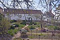
Monastery garden in Altomünster

Brauereigasthof and Hotel Kapplerbräu
Brauereigasthof and Hotel Maierbräu in Altomünster

Maierbräu brewhouse, Altomünster

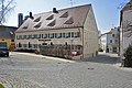
Market and town hall in Altomünster

Listed building in Sandizellergasse 9
.jpg)
_Kloster_Altom%C3%BCnster.JPG)


.JPG)
.JPG)


Economy and Infrastructure
traffic
railroad

.jpg)
Altomünster is the end point of the Dachau – Altomünster railway line and is therefore connected to the Munich S-Bahn network. The route has been fully electrified since December 14, 2014 and is served by MVV line S2. The hourly service, which offers a direct connection without changing trains through the main route to Erding , is compressed to half an hourly service during rush hour.
Before the electrification and modernization, diesel trains of the type VT 628 operated on the route under the designation "Line A".
Street
The district road DAH 2 runs through Altomünster. The closest exits on the A 8 federal motorway are Adelzhausen and Odelzhausen.
UL special landing site
In Altomünster there is a special landing pad for microlight aircraft . The small airfield was created through a private initiative. The grass runway in the direction of 02/20 is only 200 m long and naturally bounded by a stream in the east and a road in the west. In 2000, a hall was built to accommodate aircraft on the site.
education
_in_Altom%C3%BCnster.JPG)
- Altomünster elementary and middle school with Gaudnek gallery. The renamed elementary school was the Comenius partner school from October 2011 to 2013 . The “Primary School” in Crook / England and the “école primaire” in Flesselles / France were declared school partners .
- Altomünster parish and parish library
- Adult Education Center Altomünster
media
The daily newspaper Aichacher Zeitung appears in the municipality .
Economy and trade
In the Altomünster region there is a wide variety of tradespeople and self-employed, e. B. retailers, craftsmen, service providers. For example, there are still all the trades that are necessary to build, refurbish or renovate a house. These companies have organized themselves in the Altomünster trade association.
The market still has two breweries that are run as private breweries:
forestry
The Altowald belongs to the market. The Altowald is the largest contiguous forest area in the Dachau district. After the secularization, the craftsmen and farmers from Altomünster and the surrounding towns were able to purchase one or more parcels of land and were glad that the wood shortage ended. That is why there are around 150 forest owners in the Altomünsterer Flur alone.
Personalities
Born in Altomünster
- Johann Marggraff (1830–1917), architect
- Franz Xaver Lang (1873–1956), inventor and engine builder
- Alois Dempf (1891–1982), philosopher
- Johann Stichlmair (* 1940), process engineer
- Alfons Schweiggert (* 1947), writer and illustrator
- Josef Mederer (* 1949), politician, president of the district assembly
- Wilhelm Liebhart (* 1951), historian and university professor
Connected with Altomünster
- Leopold Paasch (1912–1988), composer
- Wolfgang Lugmair (* 1976), painter, grew up in Altomünster
- Martina Schwarzmann (* 1979), cabaret artist, lives in Altomünster
Honorary citizen
- Anton Hofberger (1921-2004)
literature
- Romuald Bauerreiß : Euphemia, Countess of Andechs (Abbess of Altomünster, † 1180). In: Lexicon for Theology and Church. 2nd Edition. Volume 3, Column 850.
- Wilhelm Liebhart (Ed.): Altomünster: Monastery , market and community. Altomünster 1999, ISBN 3-00-005192-9 .
- Wilhelm Liebhart: The Altomünster market in the Middle Ages. In: Amperland . 1976, pp. 137-139, 155-158.
Web links
- Official website
- Entry on the Altomünster coat of arms in the database of the House of Bavarian History
- Hans Schertl: Churches and chapels in the Altomünster community.
- History of the community partnerships - (Markt Altomünster)
- Altomünster: Official statistics of the LfStat
- Altomünster Monastery
- Driver's cab ride 2018 S-Bahn Munich - S2 Ostbahnhof - Altomünster (video)
Individual evidence
- ↑ "Data 2" sheet, Statistical Report A1200C 202041 Population of the municipalities, districts and administrative districts 1st quarter 2020 (population based on the 2011 census) ( help ).
- ↑ Markt Altomünster: Council information. Retrieved May 14, 2020 .
- ^ Altomünster community in the local database of the Bavarian State Library Online . Bavarian State Library, accessed on September 11, 2019.
- ↑ Life and death in Dasing - How a Bavarian village lost its tranquility through four murders. In: The time . No. 51, December 13, 1996.
- ↑ Spider Revival Party 2.0 (Burschenverein Altomünster, accessed on December 4, 2014).
- ↑ a b c d Federal Statistical Office (Hrsg.): Historical municipality register for the Federal Republic of Germany. Name, border and key number changes in municipalities, counties and administrative districts from May 27, 1970 to December 31, 1982 . W. Kohlhammer, Stuttgart / Mainz 1983, ISBN 3-17-003263-1 , p. 571 .
- ↑ a b c Federal Statistical Office (ed.): Historical municipality directory for the Federal Republic of Germany. Name, border and key number changes in municipalities, counties and administrative districts from May 27, 1970 to December 31, 1982 . W. Kohlhammer, Stuttgart / Mainz 1983, ISBN 3-17-003263-1 , p. 570 .
- ^ Wilhelm Volkert (ed.): Handbook of Bavarian offices, communities and courts 1799–1980 . CH Beck, Munich 1983, ISBN 3-406-09669-7 , p. 415 .
- ↑ https://www.statistik.bayern.de/mam/produkte/veroffnahmungen/statistische_berichte/a1210c_201800.pdf
- ^ Bavarian State Office for Statistics and Data Processing .
- ↑ Our partner community Nagyvenyim ( Memento from July 28, 2014 in the Internet Archive ) - (Markt Altomünster, accessed on July 28, 2014).
- ^ Monastery church St. Alto and St. Birgitta in Altomünster - (Hans Schertl).
- ↑ Chapel in the guest house of the Altomünster monastery - (Hans Schertl).
- ↑ Chapel on Kalvarienberg (Dismasberg) in Altomünster - (Hans Schertl).
- ↑ Loretto Chapel in Altomünster - (Hans Schertl).
- ↑ Chapel at the Alto spring near Altomünster - (Hans Schertl).
- ↑ Altomünster - ( HdBG ).
- ↑ Chapel in the Altoland retirement home in Altomünster - (Hans Schertl)
- ↑ Evangelical Community Center in Altomünster - (Hans Schertl)
Altomünster | Hohenzell with Freistetten , Irchenbrunn , Lichtenberg , Plixenried , Rametsried and Übelmanna | Kiemertshofen with Oberschröttenloh , Radenzhofen and Schloßberg | Oberzeitlbach with Humersberg , Oberndorf , Röckersberg , Ruppertskirchen , Schauerschorn and Unterzeitlbach | Pipinsried with Breitenau , Erlach , Hutgraben , Maisbrunn , Obererlach , Ottelsburg and Ottmarshausen | Randelsried with Asbach , Lauterbach , Reichertshausen and Schmarnzell | Stumpfenbach with Deutenhofen , Hohenried and Sengenried | Thalhausen with Arnberg , Haag , Schielach , Schmelchen and Teufelsberg | Wollomoos with Halmsried , Pfaffenhofen , Rudersberg and Xyger
