
Petershausen
| coat of arms | Germany map | |
|---|---|---|

|
Coordinates: 48 ° 25 ' N , 11 ° 28' E |
|
| Basic data | ||
| State : | Bavaria | |
| Administrative region : | Upper Bavaria | |
| County : | Dachau | |
| Height : | 459 m above sea level NHN | |
| Area : | 32.79 km 2 | |
| Residents: | 6540 (Dec. 31, 2019) | |
| Population density : | 199 inhabitants per km 2 | |
| Postal code : | 85238 | |
| Area code : | 08137 | |
| License plate : | DAH | |
| Community key : | 09 1 74 136 | |
| LOCODE : | DE PTH | |
| Community structure: | 18 parts of the community | |
| Address of the municipal administration: |
Bürgermeister-Rädler-Strasse 3 85238 Petershausen |
|
| Website : | ||
| Mayor : | Marcel Fath (FW Petershausen) | |
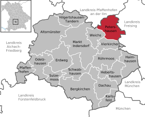
| Location of the community Petershausen in the district of Dachau | ||
  |
||

Petershausen is a municipality in the Upper Bavarian district of Dachau . It is located on the Glonn River .
geography
_-_Marktplatz.jpg)


location
Petershausen is about 36 kilometers north of Munich in the Glonntal with extensive floodplains, which are criss-crossed by economic and hiking trails. The Glonn crosses the municipality from west to east. The Wendelstein mountain, located in the Wendelstein district, rises to a little more than 460 meters, but it was chosen as early as 1500 BC. BC the people as burial mounds.
Immediately adjacent communities are:
| Jetzendorf ( Pfaffenhofen district ) | Reichertshausen ( Pfaffenhofen district ) | |
| Soft |
.svg)
|
Hohenkammer ( Freising district ) |
| Vierkirchen |
Community structure
The municipality has 18 officially named municipal parts (the type of settlement is indicated in brackets ):
|
|
Neighboring communities
The community of Petershausen is located in the far northeast of the district of Dachau and borders on the district of Pfaffenhofen an der Ilm in the north and on the district of Freising in the east .
Incorporations
On January 1, 1972, Obermarbach was incorporated. On May 1, 1978, Kollbach and part of the community of Asbach followed.
history
Already from 1,600 to 1,350 BC 10 grave mounds were laid out on the Wendelstein hill, another 18 to the west of Obermarbach.
The area of today's parish has been inhabited by humans for thousands of years. The Celts, from the Vindelicier tribe, were followed by the Romans and the Bavarians for around 400 years at the turn of the times .
Between 150 and 180 AD the Roman road Augsburg-Salzburg was built, which ran through the municipality. Parts of this important west-east connection later form the Altbaierischer Oxenweg .
Glonnbercha was mentioned in a document around the year 815. Other districts were mentioned in the 11th century. The place name Petershausen was first mentioned in 1116. The Pertrichhof in the center was built around 1500 as a tavern.
Since 1755 there was a school in Petershausen.
In 1867 the Munich - Ingolstadt railway line was built, on which the Petershausen station is located.
Population development
Between 1988 and 2018 the municipality grew from 4,481 to 6,551 by 2,070 inhabitants or 46.2%.
politics
Municipal council
The municipal council for the 2020-2026 electoral period consists of 20 members with the groups Free Voters (6 seats), CSU (6 seats), Bündnis90 / Die Grünen (3 seats), SPD (3 seats), ÜBP (1 seat) and FDP ( 1 seat).
The committees of the municipality are the municipal council, the main and finance committee, the building and environmental committee, the social committee, the auditing committee and the community foundation awarding committee.
mayor
The first mayor of the place has been Marcel Fath from the Free Voters Petershausen since May 1, 2014, he was elected in March 2014 with 54.0% of the vote.
Community finances
Figures for the years 2005 to 2009 and 2017 (in thousands of euros)
| feature | 2005 | 2006 | 2007 | 2008 | 2009 | 2017 | |
|---|---|---|---|---|---|---|---|
| Gross expenditure | 6,775 | 7,051 | 7,677 | 8,197 | 9,977 | 21.091 | |
| Municipal tax receipts | 3,598 | 4.169 | 4,937 | 5,171 | 4,552 | 7,917 | |
| Debt per inhabitant | 1.202 | 0.871 | 0.734 | 0.951 | 0.874 | 1.402 |
coat of arms
The coat of arms has been used since 1970. Oblique left divided by silver and black; above a blue fish placed to the left, below a golden plow.
The golden plow underlines the agricultural character of the municipality. The tinging alludes to the historical coexistence of the Duchy of Bavaria (white-blue) and Hochstift Freising (gold-black). The fish symbolizes at the same time the location of the community on the Glonn and, as an attribute of St. Ulrich, the patronage of the branch church in the Mühldorf district.
Community partnerships
-
 France : There has been a partnership with the French municipality of Varennes-en-Argonne since 1968 . A youth exchange takes place with this annually, which is organized by a group of young community members.
Attractions
Buildings
- Pertrichhof , in the center of Petershausen: The Pertrichhof was built as a tavern around 1500 . Around 1700 the inn was converted into a handsome baroque building with its unmistakable curved gables . It was renovated a few years ago and is the central eye-catcher on Pertrichplatz. Today it houses the Sparkasse and is protected as a monument no. D-1-74-136-2. A weekly market takes place on the forecourt on Fridays during the summer season.
- Catholic parish church St. Laurentius : Erected around 1315, high altar in 1680, Rococo design since 1750.
- Frauenkirche in Kollbach: Built around 1288, initially Gothic-Romanesque, around 1705 changed to Baroque style.
- Ulrichskirche in Mühldorf (between Petershausen and Hohenkammer ): Gothic church that was built around 1480. In 1657 a stately high altar by the Munich sculptor Konstantin Paderim was added.
- Sacred Heart Chapel : Built around 1724 on the Glonnbrücke as a pilgrimage chapel.
- Notburga Chapel in Weißling : First built in 1748 as a wooden structure, stone structure since 1768. Some of the hundred votive pictures that were made because of cattle diseases still hang on the walls .
- Burgstall Kollbach (archaeological site, only preserved as a hill).
Natural monuments
- Thousand-year-old linden tree in Obermarbach : To the north of the church there is an ancient linden tree with a trunk circumference of eight meters that has survived numerous lightning strikes.
- Landscape monument and vantage point on the road between Kollbach and Asbach: Round stone pillar with viewing holes that are labeled with the places visible from there. The pillar was awarded to the municipality for its achievements in rural development as the Bavarian State Prize 1993/1994.
nature and landscape
7 signposted hiking trails between 8 and 13 km lead through the charming landscape around Petershausen. There are cycle paths in the landscape protection area along the Glonn. You can also follow the Altbaierischen Oxenweg . There is an educational forest trail in Kollbach. The wedding place in Obermarbach is worth seeing.
Picture gallery

Parish Church of St. Laurentius

Catholic Parish Office St. Laurentius - Parish Association Petershausen-Vierkirchen-Weichs

Sacred Heart Chapel in Petershausen

St. Vitus in Obermarbach

Parish Church of St. Peter and Paul, Asbach

Church of St. Martin in Kollbach

Ev.-Luth. Kemmoden-Petershausen Church

Baroque building in Asbach (formerly part of the mill in Asbach)

Petershausen im Glonntal (view from the south)

Landscape monument in Kollbach

Hollow linden tree in Obermarbach (west view)
_-_St._Laurentius_(I).jpg)


_01.jpg)
.jpg)
_06.jpg)

_03.jpg)

.jpg)

traffic
Petershausen is about ten kilometers from the Allershausen motorway junction of the A 9 and five kilometers from the federal highway 13 .


The railway stopped here for the first time in 1866; Today Petershausen is the northern end of the S-Bahn line 2, but is also served by regional trains every hour to half an hour and is on the Munich – Treuchtlingen railway line . With the S2 there is a 20 or 40-minute cycle in the MVV . Since the train station is on the Munich-Nuremberg route, the Munich-Nuremberg Express and the Regional Express to and from Ingolstadt also stop . The journey time to the main train station in Munich is 38 minutes with the S-Bahn and between 15 and 20 minutes with the regional train, depending on the connection.
The Altbaierische Oxenweg and the Nuremberg-Munich cycle route run through Petershausen .
education
In Petershausen there are the following facilities for children and schoolchildren:
- Petershausen Elementary School (with Noah's Ark Hort)
- Elementary and middle school " Active School Petershausen "
- Mosaic kindergarten Petershausen
- Forest kindergarten Petershausen
School buses run to the secondary schools in Weichs and Markt Indersdorf , as well as to the Markt Indersdorf grammar school.
economy
The area around Petershausen is primarily agricultural, with arable farming and cattle breeding, which is also expressed by the plow in the coat of arms. In the east and north-east there are commercial areas with medium-sized industrial and craft businesses.
Honorary citizen
- Jan Simon Fach, Bad Salzschlirf
- Johann Hammerl, Kollbach
- Josef Hefele, Kollbach
- Ferdinand Ostermair, Petershausen
- Stefan Pfister, Petershausen
- Ludwig Zins, Petershausen
literature
- Lydia Thiel and Elisabeth Mecking: Chronicle of the community Petershausen [1] - House chronicle , Bd. 1, Asbach - Mühldorf, Ed .: community Petershausen and working group Ortschronik Petershausen, Petershausen 1999
- Lydia Thiel and Elisabeth Mecking: Chronicle of the community Petershausen [1] - house chronicle , vol. 2. Oberhausen - Ziegelberg, publisher: community Petershausen and work group Ortschronik Petershausen, Petershausen 1999
- Lydia Thiel and Elisabeth Mecking: Chronicle of the community Petershausen [2] - history ; Vol. 1. Landscape, politics, economy, society, publisher: Petershausen community and Ortschronik Petershausen work group, Petershausen 2000
- Lydia Thiel and Elisabeth Mecking: Chronicle of the community Petershausen [2] - history ; Vol. 2. Art and culture, publisher: Petershausen community and Ortschronik work group Petershausen, Petershausen 2000
Web links
- Website of the Petershausen community
- Entry on the coat of arms of Petershausen in the database of the House of Bavarian History
- Petershausen: Official statistics of the LfStat
- Hans Schertl: Churches and chapels in the parish of Petershausen
Individual evidence
- ↑ "Data 2" sheet, Statistical Report A1200C 202041 Population of the municipalities, districts and administrative districts 1st quarter 2020 (population based on the 2011 census) ( help ).
- ^ Petershausen community in the local database of the Bayerische Landesbibliothek Online . Bavarian State Library, accessed on September 10, 2019.
- ^ Wilhelm Volkert (ed.): Handbook of Bavarian offices, communities and courts 1799–1980 . CH Beck, Munich 1983, ISBN 3-406-09669-7 , p. 444 .
- ^ Federal Statistical Office (ed.): Historical municipality directory for the Federal Republic of Germany. Name, border and key number changes in municipalities, counties and administrative districts from May 27, 1970 to December 31, 1982 . W. Kohlhammer, Stuttgart / Mainz 1983, ISBN 3-17-003263-1 , p. 571 .
- ↑ https://www.statistik.bayern.de/mam/produkte/veroffnahmungen/statistische_berichte/a1210c_201800.pdf
- ↑ Statistics Bavaria - Municipal elections 2014 , accessed on July 29, 2019
- ^ Süddeutsche Zeitung: Petershausen is changing its face. Retrieved March 24, 2020 .
- ↑ http://www.wahlen.bayern.de/kommunalwahlen/
- ↑ https://www.statistik.bayern.de/statistikkommunal/09174136.pdf
- ↑ www.varennes-petershausen.de ( Memento of the original from March 12, 2010 in the Internet Archive ) Info: The archive link was inserted automatically and has not yet been checked. Please check the original and archive link according to the instructions and then remove this notice.
