Frieda (Werra)
| Frieda | ||
|
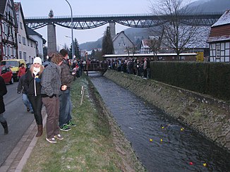
Frieda built it in Lengenfeld under the stone; in the background the Lengenfeld viaduct crossing the stream |
||
| Data | ||
| Water code | EN : 4178 | |
| location | Thuringia , Hessen , Germany | |
| River system | Weser | |
| Drain over | Werra → Weser → North Sea | |
| source | west of Struth 51 ° 13 ′ 26 ″ N , 10 ° 17 ′ 42 ″ E |
|
| Source height | 465 m above sea level NN | |
| muzzle |
Frieda coordinates: 51 ° 11 '16 " N , 10 ° 7' 44" E 51 ° 11 '16 " N , 10 ° 7' 44" E |
|
| Mouth height | approx. 161 m above sea level NN | |
| Height difference | approx. 304 m | |
| Bottom slope | approx. 17 ‰ | |
| length | 18.4 km | |
| Catchment area | 171.8 km² | |
| Drain |
MNQ MQ |
335 l / s 1.339 m³ / s |
| Left tributaries | Faulunger Bach (4.4 km,> 10 km²), Rosebach (3.7 km), Tiefer Graben (2.2 km) | |
| Right tributaries |
Lutter (12.1 km, 36.5 km²), Rosoppe (11.3 km, 49.7 km²), Rode (9.3 km, 29.0 km²) |
|
| Communities | Struth , Lengenfeld unterm Stein , Geismar , Großtöpfer , Frieda | |
The Frieda is an 18.4 km long right or northeast tributary of the Werra in the border area of Thuringia and Hesse in ( Germany ).
Surname
The name of the flowing water was mentioned in a document in 1583 as "Friede", it gave the place Frieda its name.
course
A named Frieda spring is located immediately northeast of the Zella monastery and south-southwest of Gut Annaberg at 379.1 m . Opposite this, the Frieda spring, which is mostly used today, is located significantly northeast and higher than the latter, directly on the western outskirts of Struth at around 465 m .
The stream initially flows in a south-westerly direction past the Zella monastery, where the first mill once stood. With the mouth of the Faulunger Bach coming from Faulungen , Frieda now takes over its north-west direction and reaches Lengenfeld unterm Stein (the Rosebach flows in from the left immediately below) and finally Geismar .
Between Lengenfeld and Geismar, the Lutter coming from Großbartloff flows to you from the right , immediately below Geismar and finally, also from the right, the Rosoppe coming from Flinsberg , Martinfeld and Ershausen . The valleys of the latter two rivers border the Westerwald north of the middle Frieda from east and west.
After the Rode, coming from Armaments and Wiesenfeld in the north-west, also flowed in from the right immediately below the Rosoppes , the Frieda turns to the south-south-west in order to pass the Hessian border after flowing through Großtöpfers and, between Eschwege in the west and Wanfried in the east, near Frieda (Municipality part of Meinhard ) to flow into the east Weser source river Werra coming from the southeast .
In the section of the Frieda, which is roughly between Lengenfeld unterm Stern and Großtöpfer, there used to be a section of the Leinefelde – Treysa railway , part of the strategic railway line known as the Kanonenbahn . The Kanonenbahn crossed the river several times - on the one hand with the Lengenfeld Viaduct in Lengenfeld and on the other hand together with the Heiligenstadt – Schwebda railway north of the town of the same name over the Fried Viaduct, which was blown up in 1945 .
Tributaries
The Frieda river system has a pronounced fan shape, in which four main arms are involved, which alone drain 153.6 of the 171.8 km² catchment area (counterclockwise from southeast to northwest) :
-
Obere Frieda to the mouth of the Lutter (9.5 km, 38.4 km²)
- Rosebach (l; 3.7 km - Hildebrandshausen )
- Faulunger Bach (l: 4.4 km - Faulungen )
- Frieda-Oberlauf (source in the west of Struth ; Zella Monastery , Lengenfeld )
- Bach vom Spreuwinkel (r; 2.2 km - mouth above Lengenfeld)
- Stream from Effelder Tal (r; 1.5 km - confluence in Lengenfeld)
-
Lutter (r; 12.1 km, 36.5 km²)
- Rottenbach (r; 1.8 km - mouth above Großbartloffs)
- Bach from Effelder (r; 1.7 km - source in the north of Effelder )
- Lutter ( Wachsedt , Großbartloff )
- Wolfentalsbach (r; 2.6 km - mouth in Großbartloff)
-
Rosoppe (r; 11.3 km, 49.7 km²)
- Bach from Wilbich (1.4 km - Wilbich )
- Rosoppe (source in Flinsberg ; Martinfeld , Ershausen )
- Schlossbach (r; 4.3 km ,> 10 km² - Bernterode )
- Krombach (r; 5.1 km - Krombach ; mouth in Ershausen)
- Tiefenbach (r; 2.9 km - source in the north of Misserode )
-
Rode (r; 9.3 km, 29.0 km²)
- Rode (sources near Schwobfeld ; armaments , Wiesenfeld , Sickerode )
- Hesselbach (r; 3.7 km - mouth in Wiesenfeld)
- Hühnerbach (r; 3.6 km - Volkerode )
Only 5.7 km² drain to the river section around Geismar between the Lutter and Rosoppes estuary, only 0.1 km² between the Rosoppe and Rode estuaries and 12.4 km² to the estuary from Großtöpfer to Frieda . T. (5.0 km²) is located in Hesse. The 2.2 km long deep ditch (source in Bebendorf ) which flows out here on the left is the only tributary that crosses the state border.
The mean discharge ( MQ ) of Frieda is 1,339 l / s, which corresponds to a mean discharge rate (Mq) of 8.8 l / s · km², the mean low water discharge (MNQ) is 335 l / s.
Neighboring river systems
The headwaters of the Faulunger Bach, Frieda and Lutter are located on the Elbe-Weser watershed directly opposite the Unstrut and its first right tributaries ( Felchtaer Bach , Luhne and Unstrut itself) to the east, while immediately north of the Rosoppe and its larger tributaries Krombach and Tiefenbach Catchment area of the Leine, which drains over the Aller to the Weser (left tributaries Geislede and Lutter ) begins. Only the Rode lies in the Walse , another tributary of the lower Werra to the northwest.
Water condition
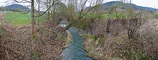
The Frieda flows mainly in a straightened stream bed, which z. B. in the local area of Lengenfeld / Stein is built with concrete. A near-natural brook forest of ash and white willow has formed in places on the embankments.
Overall, the ecological condition of the lower reaches is considered unsatisfactory.
Mills
There were at least 11 mills on the Frieda, and there are more mills on the tributaries.
- Struth: the monastery mill
- Lengenfeld / Stein: Hagemühle , Obermühle , Mittelmühle , Teufelsnasen-Mühle
- Geismar: Obermühle , Mittelmühle . Under mill
- Large potter : Auleppsche Mühle , Hahnenmühle
- Frieda: Pot mill
Individual evidence
- ↑ a b Topographic map 1: 25,000
- ↑ a b c d River lengths according to Geoppfad (kmz, 42 kB)
- ↑ The length over the source marked on the maps as Friedaquelle immediately north of Zellas monastery ( 379.1 m ) is 17.0 km, over the Lutter the Frieda is 20.1 km long. However, the Thuringian State Office and coarser maps base the source west of Struth at around 465 m .
- ↑ a b c d Thuringian State Agency for the Environment (ed.): Area and water code index and map. Jena 1998; 26 pp.
- ↑ a b c Profile surface water body: Frieda (DETH_4178_0 + 18). November 19, 2009, archived from the original on February 6, 2013 ; Retrieved June 18, 2016 .
- ↑ a b Map of the flowing waters of Thuringia ( Memento of the original from July 19, 2011 in the Internet Archive ) Info: The archive link was automatically inserted and not yet checked. Please check the original and archive link according to the instructions and then remove this notice. - PDF, 1.23 MB
- ↑ Volker Große, Klaus Herzberg: Mills in the Obereichsfeld . In: Maik Pinkert (Ed.): A compendium . Eichsfeld-Verlag, Heiligenstadt 2008, ISBN 978-3-935782-13-5 , p. 400 .
Web links
- Map of the rivers of Thuringia - PDF, 1.23 MB
- Map / aerial photo of the Frieda river system


