
General plan east
The term Generalplan Ost (GPO) summarizes a number of plans, planning sketches and lecture materials for a possible new settlement structure within the framework of the National Socialist " Ostpolitik ". Based on the Nazi racial doctrine, these theoretical concepts formed a planning basis for the colonization and “ Germanization ” of parts of East Central and Eastern Europe. Such documents had been produced since the spring of 1940 by the planning office of the Reich Commissioner for the Consolidation of German Volkstum (RKF), the planning group III B at the Reichsführer SS Security Service in the Reich Security Main Office (RSHA) and the Institute for Agriculture and Agricultural Policy at the Friedrich Wilhelms University in Berlin .
Work on the various plans between 1940 and 1942 was initially carried out on behalf of Reichsführer SS Heinrich Himmler , and later also on behalf of the Nazi "chief ideologist" Alfred Rosenberg . With the turn of the war in 1943 , both the General Plan East as were the later in this uplifting General settlement plan doomed to failure.
background
The concept of "living space in the east"
Main article: Habitat in the east
While the Germans waged wars in the 19th century to achieve a unified nation state and could only realize this with the establishment of the empire in 1871, imperialism was already in its heyday of the western European states . Chancellor Bernhard von Bülow began to claim “our place in the sun ” for Germany in front of the Reichstag in 1897 , which should mean colonies and zones of influence and overall “world politics”. In 1916, Bülow tied in with Gustav Freytag's idea of the medieval eastern settlement as the “greatest deed of the German people in that period”, which had been developed by Gustav Freytag since 1859, and stated: “The huge eastern colonization work is the best, the most lasting result of our illustrious medieval history. “In the first German historians ' dispute , the Sybel-Ficker dispute , it was ostensibly about the comparison of the medieval eastward expansion with the Italian policy of the Roman-German emperors , but also about answering the political orientation of the emerging nation-state. With reference to the medieval conquest of German-speaking settlers in Central and Eastern Europe, the idea of German border colonization became increasingly popular. With Gustaf Kossinna and Friedrich Ratzel , the historical perspective was joined by archaeological and geographical considerations which, in the imperialist concert, focused on the border-colonizing German expansion to “living space in the east”. Since 1875 Paul de Lagarde has translated them most effectively and effectively into political demands by propagating the “gradual Germanization of Poland” as the highest goal of German politics. In German society, especially among nationalist intellectuals, this increasingly gave rise to the idea of a natural, specific “German drive to the East ”. When the “ Pan-German Association ” was founded in 1891, it was said: “The old urge to the East should be revived.” The völkisch movement in the Wilhelmine Empire spread these ideas further. The German war aims in the east developed in 1918 during the First World War were also in this tradition. The idea of solving the social problems and the supposed overpopulation of Germany by gaining new settlement area in Eastern Europe was expressed with the catchphrase of “ people without space ”, which during the 1920s during the Weimar Republic a . a. was disseminated by the writer Hans Grimm ; In addition, the idea of living space was propagated by the geographer Karl Haushofer, an important pioneer of National Socialism .
Eastern imperialism in the time of National Socialism

With the conquest of the western part of Poland, ideas about the settlement of this area should be realized. The use of the term " Ober-Ost " in Hitler's secret decree of October 7, 1939 on the "consolidation of German nationality" is instructive. Section II states: “In the formerly occupied Polish territories, the Ober-Ost administration chief carries out the tasks assigned to the Reichsführer SS in accordance with his general instructions. The chief administrator of Upper East and subordinate administrative heads of military districts contribute for the implementation of the responsibility. "The agricultural scientist Konrad Meyer , since 1939 is closely related to that of Albert Brack man guided and Ostforschung competent Publication place Berlin-Dahlem standing and how Brackmann a supporter of "Eastern colonization mission", after the attack on Poland in April / May 1940, had already been planning the "German reconstruction in the east" in the incorporated eastern areas, the Reichsgauen Wartheland and Danzig-West Prussia . A larger overall plan was commissioned by Heinrich Himmler from Meyer two days after the attack on the Soviet Union on June 22, 1941 , with which Himmler's settlement program was to be concretized. The first version of the plan was available on July 15, 1941; On July 30, 1941, during a visit to Lublin, Himmler ordered the local SS and police leader Odilo Globocnik to create “a large settlement area in the area around the already existing ethnic German colonies near Zamość ” (cf. Aktion Zamość ). In the course of this action, around 110,000 Poles from the Zamość district were resettled from 300 villages. In addition to the settlement campaign in Hegewald near Zhytomyr, it represented the only decisive attempt by German settlement policy.
The reasons for choosing Zamość were the existence of descendants of German settlements from the 18th century and the favorable transport and geopolitical location of the Zamość area, which was suitable as a connecting bridge between the empire and the occupied territories of the USSR.
Some plans envisaged to parts of the population of Poland and the western parts of the Soviet Union to Siberia to deport . According to the version presented on May 28, 1942 and revised again in December, the Wartheland , East Upper Silesia and West Prussia including parts of the “Generalgouvernements of Poland” (GG) were to be completely “Germanized” and three “Reichsmarks” formed in parts of the conquered Soviet Union:
- " Ingermanland " south of Leningrad;
- the Narew area with Białystok and Lithuania ;
- the "Gotengau" with Crimea and the area around Kherson .
The period of 25 years initially set for “Germanization” was reduced to 20 years on December 23, 1942, and Bohemia and Moravia , Alsace-Lorraine , Lower Styria and Upper Carniola were also assigned to the planning at Himmler's request. The "vacated areas" in Eastern Europe should be populated with several million Germans. A military victory against the Soviet Union would have been a prerequisite for the full implementation of the plans .
After the defeats of the German troops near Moscow (winter 1941/1942) and Stalingrad (winter 1942/1943), however, the realization of the plan became increasingly distant. The degree of actual scope and the question of which parts of the GPO would actually have been or have been implemented is the subject of various scientific controversies to this day . It should be noted here that the GPO involved different, sometimes competing plans from different bodies. This planning competition can be seen as typical for many Nazi projects, since the leader principle mostly prevented a clear delimitation of planning sovereignty. In this respect, it is unclear which plans or planning aspects would actually have been pursued further. The lack of some planning documents (missing since 1945) also makes research difficult. However, Himmler himself drafted in a speech to SS and police leaders of the South Russia area in Hegewald near Zhytomyr on September 16, 1942 and in a second to SS Junkers in Bad Tölz on November 22, 1942 under the heading “Today colony, tomorrow Settlement area, rich the day after tomorrow! ”A revealing picture of his own ideas.
Expulsion and extermination of the Slavic population of Eastern Europe
Since the majority of the indigenous Slavic peoples seemed unsuitable for Germanization and "Germanization" was only planned for a small part, the decimation of the 30 million associated with settlement by ethnic Germans or Northern Europeans provided for:
- Extermination or displacement of 80–85% of Poles;
- Extermination or displacement of 50–75% of Czechs;
- Extermination of 50–60% of the Russians in the European part of the Soviet Union, another 15–25% were intended for relocation to the east (ie resettlement or expulsion behind the Urals, to Siberia);
- Extermination of 25% of the Ukrainians and Belarusians, another 30-40% of the Ukrainians and another 30-50% of the Belarusians should be "expelled" to the East.
In fact, around 30 million members of the military and civilians from Eastern European countries had been killed by the end of the war . The Soviet Union lost 10% of its population (Ukraine and Belarus 25%), Poland 17%. In addition to Russians, Ukrainians, Belarusians, Poles, Czechs, Slovaks, Russians, etc., members of non-Slavic peoples (mainly Jews, Roma and Sinti, but also Estonians, Latvians, Lithuanians, Tatars, Caucasians, Karelians, etc.) were among the victims .
The Eastern European historian Timothy Snyder sees in the German hunger plan of May 1941, according to which “agricultural products from Ukraine and southern Russia […] will be brought to Germany and around 30 million people in Belarus, northern Russia and in large Soviet cities will be exposed to starvation [should] "essentially" a prelude to the "General Plan East" "and this in essence as a" plan for the colonization of the western Soviet Union, which made around 50 million people its disposal. "
Elaborated variants of the general plan east
These documents were created by the Planning Office of the Reich Commissioner for the Consolidation of German Volkstum (RKF), Planning Group III B in Office III (SD-Inland) of the Reich Main Security Office of the SS and the Institute for Agriculture and Agricultural Policy of the Friedrich Wilhelms University in Berlin . In detail, the documents concerned were as follows:

- Document 1: “Planning Bases”, created in February 1940 by the RKF Planning Office (21 pages). Contents: Description of the extent of the planned eastern settlement in West Prussia and in the Wartheland . The planned area should cover an area of 87,600 km², 59,000 km² of which is agricultural land. Around 100,000 settler farms measuring 29 hectares were to be established in this area. A total of around 4.3 million Germans were to be settled in these areas; of which 3.15 million in rural areas and 1.15 million in urban areas. To this end, 560,000 Jews (100% of all people of this ethnic group in the planning area) and 3.4 million Poles (44% of all people of this ethnic group in the planning area) were to be removed. No estimates have been made of the total cost of the plan.
- Document 2: Materials for the “Settlement” lecture, prepared in December 1940 by the RKF planning office (5 pages). Content: Basic article on "Land requirements for the necessary evacuation from the Old Reich " with a specific demand of 130,000 km² for 480,000 new, viable settler farms of 25 ha, with 40% surcharge for forest, Wehrmacht , reserve areas in Wartheland and Generalgouvernement Poland.
- Documents drawn up after the attack on the Soviet Union on June 22, 1941.
- Document 3 (lost, exact content unknown): "Generalplan Ost", created in July 1941 by the RKF planning office. Content: Description of the extent of the planned eastern settlement in the Soviet Union with concrete geographical delimitation of the individual settlement areas.
- Document 4 (lost, exact content unknown): "Overall plan East", created in December 1941 by planning group III B of Office III (SD-Inland) of the RSHA under SS-Standartenführer Dr. Hans Ehlich . Content: Description of the extent of the planned eastern settlement in the Soviet Union and the Generalgouvernement with concrete geographical delimitation of the individual settlement areas.
- Document 5: “Generalplan Ost”, created on May 28, 1942 by the Institute for Agriculture and Agricultural Policy at the Friedrich Wilhelms University in Berlin (84 pages).
Content: Description of the extent of the planned eastern settlement in the Soviet Union with concrete geographical delimitation of the individual settlement areas. The planned area was to cover 364,231 km², including 36 “settlement bases” and three “settlement marks” in the Leningrad area (now Saint Petersburg), the Crimea - Kherson area and the Memel - Narew area ( Białystok district and western Lithuania). Settler farms with an area of 40-100 hectares and large agricultural operations with at least 250 hectares should be created. The number of settlers required for this was estimated at 5.65 million. To this end, around 31 million people from the planned area were to be deported to Siberia or murdered. The cost of the planning was estimated at 66.6 billion Reichsmarks . - Document 6: “ General settlement plan”, created in September 1942 by the RKF planning office (scope: 200 pages including 25 maps and tables).
Content: Description of the scope of the planned settlements in all conquered areas intended for this purpose, with specific geographical delimitation of the individual settlement areas. The planned area should cover 330,000 km² with 360,100 farms. The number of settlers needed for this was estimated at 12.21 million people (of which agricultural and forestry professionals: 2.859 million). To this end, around 30.8 million people should be removed from the planned area. The cost of the planned measures was estimated at 144 billion Reichsmarks .
See also:
Realized sub-elements of the planning
Due to the course of the war, only partial elements of the planning related to the following documents were implemented:
Document 1 : “Planning bases”, created in February 1940 by the RKF planning office (scope: 21 pages). Contents: Description of the extent of the planned eastern settlement in West Prussia and in the Wartheland . The following population policy measures were implemented in the two areas that were directly incorporated into the German Reich.
- Reichsgau Wartheland
- First close-up plan . According to this plan, 87,883 people (ethnic Poles and Jews) had been deported from the Wartheland to the Generalgouvernement by December 17, 1939 .
- Interim plan . According to this plan, between February 10 and March 15, 1940, a total of 40,128 people (ethnic Poles and Jews) were deported to the Generalgouvernement .
- Second close-up plan . According to this plan, 121,594 people (ethnic Poles and Jews) were deported to the Generalgouvernement between May 1940 and January 20, 1941 .
In addition, by March 15, 1941, another 19,226 people had been brought to the Generalgouvernement. These figures add up to a total of 280,606 deportees. Some historians even assume higher estimated numbers of deportees, up to a maximum of 650,000 people for the area of the Reichsgaues Wartheland .
Until the deportations stopped in 1942, tens of thousands of people (ethnic Poles and Jews) from the Reichsgau Danzig-West Prussia were deported to the General Government.

Document 5 : “Generalplan Ost”, created in May 1942 by the Institute for Agriculture and Agricultural Policy at the Friedrich-Wilhelms-Universität in Berlin (68 pages). Content: Description of the extent of the planned eastern settlement in the Soviet Union with concrete geographical delimitation of the individual settlement areas.
Settlement bases to be set up are also listed within this plan. The concept has been partially implemented in two areas, namely in the General Government and Western Ukraine .
- Zamość area
As part of the Zamość campaign , the area of the city and the district of Zamość were supposed to be "German populated" and the Polish population living there should be deported. In order to implement this plan, the SS Landwacht Zamosc , consisting of ethnic German settlers, was set up at the end of 1942 on the orders of the HSSPF Lublin, Odilo Globocnik . 60,000 settlers - Polish “Germans of origin” and above all “ethnic Germans” - should be settled. Around 110,000 Poles were resettled for this purpose. In fact, only 9,000 German settlers could be settled. Due to the strong growth of the partisan movement in this area, the settlement of further people failed. The measures were officially discontinued in August 1943.
- region Zhytomyr
Almost simultaneously with the Zamość campaign, between autumn 1942 and the end of 1943 , the construction of a settlement base in Hegewald near Schytomyr around Himmler's headquarters began: around 15,000 Ukrainians were deported to this area and 10,000 ethnic Germans settled in their place.

Expulsion of Poland by the Wehrmacht - Saybusch-Aktion , 1940

"[...] the most generous resettlement campaign in world history." Propaganda poster for the colonization of the Warthegau
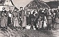
Expulsion from Poland by the SS - Aktion Zamość , 1942

Arthur Greiser greets the millionth ethnic German resettled in Litzmannstadt, March 1944


Document 6 : “ General settlement plan”, created in September 1942 by the RKF planning office (scope: 200 pages including 25 maps and tables).
Two sub-elements named in detail in the general settlement plan have been implemented:
- Resettlements in the so-called Ranner triangle in the CDZ area of Lower Styria (today's Slovenia ):
Around 40,000 Slovenes from the area of the Ranner triangle were deported to Serbia and Croatia to make room for the resettlement of 12,000 Germans from the area of the Gottscheer language island (Gottschee lay in the area of southern Slovenia annexed by Italy ). - Around 100,000 French-speaking people were deported from Alsace , Lorraine and Luxembourg to unoccupied France . The focus of these measures was the French-speaking area around the north-western town of Metz .
The course of the Second World War prevented the further implementation of the various plans. To this day it has not been conclusively clarified whether or which of the various plans should ultimately guide the action. This problem arises in particular due to the competing planning situation (different facilities or institutes each developed their own different plans) and the fact that important planning documents have disappeared since 1945, the content of which can no longer be reconstructed.
The “feudal” and “marrow” terms in the plans and their history
The potential settlers are called “feudal takers” in the GPO. Other terms used in this context are "fief", "fiefdom", “fiefdoms and places”, “temporary loan”, “inheritance”, “feudal courts”. All of these terms come from the period of feudalism . The word “fief” as a property lent for use goes back to the old Germanic language and determined the feudal legal and social order of the Middle Ages since the 8th century .
The various drafts also mention the settlement areas to be created as “settlement marks” or “imperial marks” “at the forefront of German folk compared to Russian and Asian” (draft of May 28, 1942), with one at the top "Markhauptmann" should come to stand. Overall, the stamps were under the sovereignty of the Reichsführer SS.
Outside the GPO, the "Mark" designation was used for the areas occupied in Eastern Europe until 1942. The Reichskommissar Ukraine , Erich Koch , intended to transform the Ukraine as the new “German Ostmark” into an object of economic exploitation for the Greater German Reich .
The “mark” term, like the “feudal” term, refers to the Middle Ages. He can be found in the Franconian Empire since Charlemagne z. B. in the Avarmark as the area of origin of the marchia orientalis or Ostarrîchi and later in Eastern Franconia since Heinrich I and Otto the Great (cf. Sächsische Ostmark ). Based on this, the term mark referred to the border area of an empire in medieval Europe. The etymology of "Mark" comes from the Old High German "marcha", meaning "border" is and in the Middle High German can also mean "borderland", "Gau" or more generally "territory". “Frontier” is a word borrowed from West Slavonic in the 13th century, which “gradually spread from the eastern colonization areas over the German language area and displaced the native word Mark [...]” (cf. Duden , vol . 7: Etymology ).
Consequences of the advance of the eastern border
On March 15, 1938, after the “ Anschluss ” of Austria as his “ Otto Company ”, Adolf Hitler had explained to his new compatriots from the balcony of the Hofburg in Vienna : “The oldest Ostmark of the German people should from now on become the youngest bulwark of the Germans Nation and thus of the German Reich. ”In 1942, with the advance of the border in the Eastern European war zone, the position of the“ oldest Ostmark ”as the“ youngest bulwark ”was overtaken, so that the“ Bavarian Ostmark ”was renamed“ Gau Bayreuth ”as well as the Short-term designation "Ostmark" for Austria on 19 January 1942 by order of Hitler was converted into " Donau- und Alpenreichsgaue ".
After the offensive of the Wehrmacht in the summer of 1942 had shifted the border further east, Himmler ordered the " Operation Zamość " to be carried out in November . Because he had identified the old German colonial area there after "his outpost in the east" Globocnik (Peter Black) came across traces of German settlers there.
literature
- Götz Aly , Susanne Heim : thought leaders of annihilation. Auschwitz and the German plans for a new European order , first edition 1991, revised new edition 2013, Fischer Taschenbuch 19510, Frankfurt (Main) 2013, ISBN 978-3-596-19510-7 , especially p. 368 ff.
- David Blackbourn : The Conquest of Nature. A history of the German landscape . Pantheon, Munich 2008, ISBN 978-3-570-55063-2 , therein Chapter 5 “Race and Soil Reclamation ” , pp. 307–376.
- Matthias Burchard: The General Plan East, a dark chapter in the history of science in Berlin . Humboldt-Universität, Berlin 1997, ( Humboldt-Universität zu Berlin, Economics and Social Sciences at the Agricultural-Horticultural Faculty Working paper 38, ZDB -ID 2371442-6 )
- Michael Burleigh : Germany Turns Eastwards. A Study of Ostforschung in the Third Reich . Pan Macmillan, London 2002, ISBN 0-330-48840-6 .
- Helmut Heiber: The General Plan East . In: Vierteljahrshefte für Zeitgeschichte . Documentation 6, 1958, Issue 3, pp. 281–325, available online in the VfZ issue archive .
- Isabel Heinemann: Race, Settlement, German Blood. The Race and Settlement Main Office of the SS and the racial reorganization of Europe . Wallstein, Göttingen 2003, ISBN 3-89244-623-7 .
- Peter Longerich : Heinrich Himmler. Biography . Siedler, Munich 2008, ISBN 978-3-88680-859-5 .
- Czeslaw Madajczyk (Ed.): From the General Plan East to the General Settlement Plan. Documents . Saur, Munich 1994, ISBN 3-598-23224-1 .
- Mechthild Rössler, Sabine Schleiermacher (ed.): The "General Plan East". Main lines of the National Socialist planning and extermination policy . Akademie, Berlin 1993, ISBN 3-05-002445-3 (Writings of the Hamburg Foundation for Social History of the 20th Century) .
- Bruno Wasser: Himmler's spatial planning in the east. The General Plan East in Poland 1940–1944 . Birkhäuser, Basel 1994, ISBN 3-7643-2852-5 .
Web links
- “Science - Planning - Displacement. The General Plan East of the National Socialists. ”An exhibition by the German Research Foundation from September 28 to October 27, 2006 in the foyer of the Bonn Science Center
- General Plan East, June 1942 , in: 1000dokumente.de
- Environment of the "General Plan East"
- "General Plan East" at LitDok East Central Europe / Herder Institute (Marburg)
- Dietrich Eichholtz "General Plan East" for the enslavement of Eastern European peoples
- Background information and educational material on the General Plan East
Individual evidence
- ↑ Cf. Gerd Fesser , "We also demand our place in the sun!" Driving forces and goals of Bülow's "Weltpolitik", p. 25. In: Gerd Fesser, The dream of a place in the sun. German “Weltpolitik” 1897–1914 , Donat-Verlag, Bremen 1996, pp. 25–34.
- ^ Prince von Bülow, Deutsche Politik, Berlin 1916, p. 221.
- ↑ Ulrich Sieg, Germany's prophet. Paul de Lagarde and the origins of modern anti-Semitism , Hanser, Munich 2007, p. 173.
- ↑ Wolfgang Wippermann, The 'Deutsche Drang nach Osten'. Ideology and reality of a political catchphrase . Darmstadt 1981, p. 87.
- ↑ See materials for the “Generalplan Ost” . On July 21, 1940, the Ober Ost staff was converted into that of the military commander in the Generalgouvernement (MiG) (see Federal Archives: Heeresgruppen / Oberbefehlshaber. ( Memento of the original from February 15, 2009 in the Internet Archive ) Info: The archive link was automatically inserted and not yet checked. Please check the original and archive link according to the instructions and then remove this note. ).
- ↑ See Michael Burleigh, Germany Turns Eastwards. A Study of Ostforschung in the Third Reich , London 2002, p. 146 f.
- ↑ Cf. I. Heinemann, 2003: Konrad Meyer and the "Generalplan Ost" , p. 2. (PDF; 174 kB)
- ↑ Cf. Isabel Heinemann, Rasse, Siedlung, Deutsches Blut. The Race and Settlement Main Office of the SS and the new racial order in Europe , Wallstein: Göttingen 2003, p. 445; Peter Longerich , Heinrich Himmler. Biography , Siedler: München 2008, p. 598 f.
- ↑ See reprint and analysis of the speech in Himmler's and Hitler's symbolic politics with medieval rulers (PDF; 1.9 MB).
- ^ See agreeing The Times Atlas Second World War , Augsburg 1999, p. 91; H. Holborn, Deutsche Geschichte id Neuzeit , Volume III, Munich 1971, p. 604; Hans Ulrich Rudolf / Vadim Oswalt (eds.), Haack TaschenAtlas Weltgeschichte , Gotha 2002, p. 186 and R. Giordano, If Hitler had won the war , Cologne 2000.
- ^ The Times Atlas Second World War , Augsburg 1999, p. 204 f. and Haack Atlas zur Geschichte , Volume 2, Gotha 1982, p. 50.
- ↑ Timothy Snyder: The Holocaust. The hidden reality ( memento of the original from October 18, 2011 in the Internet Archive ) Info: The archive link was inserted automatically and has not yet been checked. Please check the original and archive link according to the instructions and then remove this notice. . In: Eurozine , February 18, 2010, printed in: Transit , Heft 38, 2009, pp. 6–19, quoted on p. 9.
- ↑ Original in the Federal Archives Berlin, R 49 / 157a. Facsimile here .
- ↑ Jerzy Kochanowski, Maike Sach (ed.): The ethnic Germans in Poland, France, Hungary and Czechoslovakia. Myth and Reality. Fiber, Osnabrück 2006, ISBN 3-929759-84-5 , p. 180.
- ↑ Michael Wildt: History of National Socialism. Vandenhoeck & Ruprecht, Göttingen 2008, ISBN 978-3-525-03710-2 , p. 187.
- ↑ On the Wewelsburg as the ideological headquarters of the SS, Himmler had announced the goal of the Russian campaign in June 1941, before the start of Operation Barbarossa, at the only SS group leader conference that ever took place there: “The decimation of the population of the Slavic neighboring countries by 30 million . "(Cf. Richard Breitman, Heinrich Himmler. The architect of the" Final Solution " , Munich / Zurich 2000, p. 393, note 12.)
-
↑ Maria Rutowska: Wysiedlenia ludnosci polskiej z Kraju Warty do Generalnego Gubernatorstwa 1939-1941 ; Prace Instytutu Zachodniego No. 71; Poznań [Posen]: Instytut Zachodni, 2003, ISBN 83-87688-42-8 (Polish);
German abstract: German-Polish Academic Society: Dr. Maria Rutowska, The expulsion of the Polish population from the Reichsgau Wartheland in the Generalgouvernement 1939–1941 dp-ag.org ( page no longer available , search in web archives ) Info: The link was automatically marked as defective. Please check the link according to the instructions and then remove this notice. ; Lecture from November 17, 2004. - ↑ Christopher Browning , with contributions by Jürgen Matthäus: The Origins of the Final Solution. University of Nebraska Press, 2007, pp. 31-34.
- ↑ Bradley Smith / Agnes Peterson (eds.), Heinrich Himmler. Secret speeches from 1933 to 1945 and other speeches. With an introduction by Joachim C. Fest, Berlin 1974, p. 246.
- ^ Bradley Smith, Agnes Peterson (eds.), Heinrich Himmler. Secret speeches from 1933 to 1945 and other speeches. With an introduction by Joachim C. Fest, Berlin 1974, p. 246.
- ↑ Longerich (2008), p. 605 f.
- ↑ Dr. Erich Petschauer: The Gottscheer Century Book. 1980. From: www.gottschee.de , accessed on October 14, 2012
- ↑ Longerich (2008), pp. 597, 599.
- ^ Article Reichskommissariate 'Ostland' and 'Ukraine' . In: Lexicon of German History. People, events, institutions. From the turning point to the end of World War II , ed. by Gerhard Taddey, Kröner, Stuttgart 1979.
- ↑ Speeches of the Führer. Politics and Propaganda of Adolf Hitler 1922–1945, ed. v. Erhard Klöss, Munich 1967, p. 85.
- ↑ Bavarian East Mark
- ↑ Emmerich Tálos, From the liquidation of statehood to the establishment of the Reichsgaue of the "Ostmark". On the restructuring of the political administrative structure , p. 69; in: E. Tálos, E. Hanisch, W. Neugebauer, R. Sieder (eds.), National Socialist rule in Austria. A manual. Öbv & hpt. Vienna 2002. ISBN 3-209-03179-7 , pp. 55–72.
- ↑ Heinz Höhne, The Order under the Skull. The history of the SS , Weltbild: Augsburg 1995, p. 291.