Kolyma
|
Kolyma Колыма, Халыма (Chalyma) |
||
|
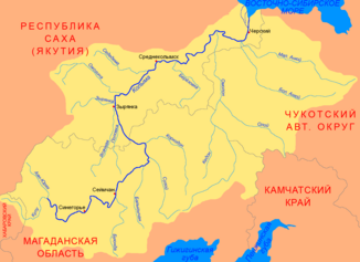
Kolyma with its tributary Omolon |
||
| Data | ||
| Water code | RU : 19010100112019000000019 | |
| location | Sakha Republic , Magadan Oblast ( Russia ) | |
| River system | Kolyma | |
| confluence | von Kulu and Ajan-Jurjach 62 ° 17 ′ 35 ″ N , 147 ° 43 ′ 57 ″ E |
|
| muzzle | in the East Siberian Sea Coordinates: 69 ° 37 ′ 46 ″ N , 161 ° 29 ′ 27 ″ E 69 ° 37 ′ 46 ″ N , 161 ° 29 ′ 27 ″ E |
|
| Mouth height |
0 m
|
|
| length | 2129 km (2513 km including the source river Kulu and its source river Kenjelitschi ) | |
| Catchment area | 647,000 km² | |
| Discharge at the gauge Sinegore A Eo : 61,500 km² Location: 1844 km above the mouth |
MQ 1936/1989 Mq 1936/1989 |
458 m³ / s 7.4 l / (s km²) |
| Discharge at the Ust-Srednekan A Eo gauge : 99,400 km² Location: 1,623 km above the mouth |
MQ 1933/2000 Mq 1933/2000 |
728 m³ / s 7.3 l / (s km²) |
| Discharge at the Srednekolymsk A Eo gauge : 361,000 km² Location: 641 km above the mouth |
MQ 1989/2000 Mq 1989/2000 |
2237 m³ / s 6.2 l / (s km²) |
| Discharge at the Kolymskoje A Eo gauge: 526,000 km² Location: 283 km above the mouth |
NNQ (April 1979) MQ 1978/2000 Mq 1978/2000 HHQ (June 1985) |
30.6 m³ / s 3254 m³ / s 6.2 l / (s km²) 26,201 m³ / s |
| Left tributaries | Popowka , Yassachnaja , Syrjanka , Oschogina , Sededema | |
| Right tributaries | Bachaptscha , Bujunda , Balygytschan , Sugoi , Korkodon , Berjosowka , Anjui , Omolon , Kamenka , Sjapjakine | |
| Reservoirs flowed through | Kolyma reservoir | |
| Ports | Ust-Srednekan , Syrjanka | |
| Navigable | around 2000 km on the lower reaches to the confluence of the Bachaptscha | |
|
Kolyma near Debin , Jagodnoye Raion , Magadan Oblast (2004) |
||
|
Tributaries of the Kolyma |
||
The Kolyma ( Russian Колыма ; Yakutian Халыма (Chalyma)) is a river in the Russian Federation District Far East in Siberia and flows into the East Siberian Sea , a marginal sea of the Arctic Ocean . Nominally it is 2129 km long, hydrologically with its source river Kulu even 2513 km. The Kolyma flows through three Rajons of Magadan Oblast and the three easternmost Ulusse of the Sakha Republic (Yakutia) .
course
The catchment area of the river has a size of 647,000 km². The water flow of the Kolyma on the lower reaches of Kolymskoje fluctuates between minimum values in winter, when it is deeply frozen (30.6 m³ / s in April 1979) and peak values in the short summers, when the permafrost surface thaws (26,201 m³ / s in June 1985). In mid-October, more rarely at the end of September, the Kolyma freezes over completely and thaws in the second half of May until June. It takes two to eighteen days for the ice to break, accompanied by massive ice drift and ice jams . The annual sediment load is 5.5 million tons.
Contrary to widespread statements, it does not originate in the Kolyma Mountains , but at the interface between the Tscherski Mountains and the Suntar-Chajata Mountains . Its main source river, the Kulu, arises on the northeast flank of the Suntar Chajata Mountains. Two further source rivers arise on the southern edge of the highlands of Oymyakon on the southern roof of the main connecting mountain range between the above-mentioned high mountains .
Above Debin , where the Kolyma Strait from Magadan via Ust-Nera to Yakutsk crosses the river on the first of two bridges, the Kolyma was dammed into a reservoir by a dam with the Kolyma hydroelectric power station . From here it can be navigated with smaller ships. The second bridge is at Ust-Srednekan , where there is a port (especially for coal shipping ). From there on, the Kolyma is also navigable for larger boats.
From there, the Kolyma first flows a little towards the southeast, only to bend towards the northeast at the end of the Tscherski Mountains and on the south side of Pik Aborigen . From then on it flows northeast of the gold-rich Kolyma Mountains towards the northeast. Then the river - flowing northwest along the Jukagiren plateau - enters the swampy East Siberian lowland , in which it continues to run in a northeastern direction. West of the Anjuigebirge the river flows into the Kolyma lowland with a 150 km wide and 100 km long delta in which the two main arms each form an estuary of about the same length into the East Siberian Sea.
From an administrative point of view, nominally six, hydrologically even seven, Rajons share in the river: The largest source river, the Kulu, has its source in the north of the Okhotsk Rajons of the Khabarovsk Kraj . The rest of the headwaters with the headwaters of the Ajan-Jurjach river are located in the west of the Sussuman district in Magadan Oblast . For this it flows into the Rajon Nagodnoje with the place Debin at the Kolymastraße . As the third district of the oblast, it flows through the Srednekan district and then reaches the Sakha Republic . There it flows through Ulus Verkhnekolymsk and Ulus Srednekolymsk and reaches the sea in Ulus Nizhnekolymsk .
shipping
Boat trips on the Kolyma are possible from June to October. Then it can be navigated by inland waterways over a length of about 2000 km and during this time it serves to supply the northern areas.
Reservoirs
The Kolyma hydro system produces 3325 million kWh annually (1970–1996).
Tributaries
The largest and longest tributary of the Kolyma is the Omolon, which flows into the lower reaches of the right from the Kolyma Mountains .
Other significant tributaries are (in order from source to mouth):
- from right: Bachaptscha , Bujunda , Balygytschan , Sugoi , Korkodon , Berjosowka and Anjui (with big and small Anjui )
- from left: Popowka , Yassatschnaja , Syrjanka , Oschogina and Sededema
Landscape image
The landscape on the Kolyma is dominated by the boreal coniferous forests of the taiga , which merges into the forest tundra and tundra towards the coast . In the last-mentioned, coldest inhabited climatic zones on earth, because of the permafrost and the low water content in the soil, tall plants such as trees cannot develop, but lichens , mosses , shrubs and ferns predominate.
Gulag prison camp
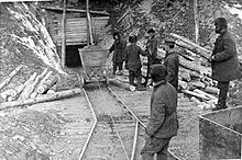
In particular, on the upper banks of the Kolyma and in the mountains there - Kolyma and Tscherski Mountains - there were several labor camps up until 1987 , in which hundreds of thousands of prisoners had to dig for gold over many decades under inhumane conditions and especially in the icy arctic cold ; this happened both in the opencast mine and underground . These prisoners came not only from the Soviet Union , but also from other countries: For example, there were many prisoners of war from the Second World War who arrived there after hundreds of kilometers of walking in the freezing cold. Then they spent many years or decades in the Siberian mountains, mainly to bring gold, tin and uranium to the light of day.
The large camp system, which was embedded in the Dalstroi complex and belonged to the Gulag system , comprised many corrective labor camps of different sizes - above all the SewWostLag - as well as the special camp of the MWD BerLag .
In his Kolyma stories , Warlam Tichonowitsch Schalamow set a literary monument to this epoch of Russian history. Also Yevgenia Ginsburg ( tightrope ) recounts her life in the Gulag system of the region during the 1940s. And Alexander Solzhenitsyn begins his autobiographical report Archipel Gulag with a prologue dedicated to the subject of Kolyma .
See also
Web links
- Hydrographic measuring points in the catchment area of the Kolyma and neighboring river systems
- UNESCO - Kolyma at Srednekolymsk further hydrological data
- UNESCO - Kolyma at Ust-Srednekan further hydrological data
- Kolyma in the State Water Directory of the Russian Federation (russ.)
- Gulag in the northeast of Russia
Individual evidence
- ↑ a b c d e Колыма. Retrieved July 19, 2016 .
- ↑ a b c Kolyma in the State Water Register of the Russian Federation (Russian)
- ↑ Kolyma at the Srednekolymsk gauge - hydrographic data from R-ArcticNET
- ↑ a b Kolyma at the Kolymskoje gauge - hydrographic data from R-ArcticNET
- ↑ a b c Kolyma at academic.ru (Russian)


