
Hames-Boucres
| Hames-Boucres | ||
|---|---|---|
.svg)
|
|
|
| region | Hauts-de-France | |
| Department | Pas-de-Calais | |
| Arrondissement | Calais | |
| Canton | Calais-1 | |
| Community association | Calaisis | |
| Coordinates | 50 ° 53 ' N , 1 ° 51' E | |
| height | 0-86 m | |
| surface | 12.82 km 2 | |
| Residents | 1,469 (January 1, 2017) | |
| Population density | 115 inhabitants / km 2 | |
| Post Code | 62340 | |
| INSEE code | 62408 | |
| Website | http://www.hames-boucres.fr/ | |
_mairie.JPG) Mairie in Hames-Boucres |
||

Hames-Boucres (NDL .: "Hames" and "Bokerdes") is a French municipality with 1469 inhabitants (as of January 1 2017) in the department of Pas-de-Calais in the region of Hauts-de-France ; it belongs to the Arrondissement of Calais and the canton of Calais-1 (until 2015: canton of Guînes ).
geography
Hames-Boucres is about eight kilometers south of Calais . Hames-Boucres is surrounded by the neighboring communities of Saint-Tricat , Nielles-lès-Calais , Fréthun and Coquelles in the north and north-west, Coulogne in the north-east, Les Attaques in the east, Guînes in the south and south-east, Caffiers in the south and south-west and Pihen-lès -Guînes in the west and southwest.
history
In 1819 the previously independent communes of Hames and Boucres were merged.
Population development
| year | 1962 | 1968 | 1975 | 1982 | 1990 | 1999 | 2006 | 2013 |
|---|---|---|---|---|---|---|---|---|
| Residents | 796 | 851 | 964 | 1,047 | 1,017 | 1.106 | 1,291 | 1,460 |
| Source: Cassini and INSEE | ||||||||
Attractions
- Saint Martin Church
- Chapel of Sainte-Victoire
- Hames Castle
- Thélu Castle
- Hermitage Palace
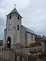
Saint Martin Church

Hames Castle
_%C3%A9glise_(02).JPG)
_ch%C3%A2teau.JPG)
Web links
Individual evidence
- ^ De Nederlanden in Frankrijk, Jozef van Overstraeten, 1969