
Guemps
| Guemps | ||
|---|---|---|

|
|
|
| region | Hauts-de-France | |
| Department | Pas-de-Calais | |
| Arrondissement | Calais | |
| Canton | Marck | |
| Community association | Région d'Audruicq | |
| Coordinates | 50 ° 55 ′ N , 2 ° 0 ′ E | |
| height | 1-5 m | |
| surface | 15.89 km 2 | |
| Residents | 1,092 (January 1, 2017) | |
| Population density | 69 inhabitants / km 2 | |
| Post Code | 62370 | |
| INSEE code | 62393 | |
| Website | http://www.guemps.fr/ | |
_mairie.JPG) Town hall (Mairie) of Guemps |
||

Guemps ( Dutch : Ganep ) is a French municipality with 1092 inhabitants (as of January 1 2017) in the department of Pas-de-Calais in the region of Hauts-de-France . It has belonged to the Arrondissement of Calais (previously Saint-Omer ) and the Canton of Marck (until 2015: Canton Audruicq ) since 2017 . The inhabitants are called Guempois .
geography
Guemps is about ten kilometers east-southeast of Calais and about 29 kilometers west-southwest of Dunkirk . Guemps is surrounded by the neighboring communities of Marck in the north and north-west, Offekerque in the east and north-east, Nortkerque in the south and south-east, Ardres in the south-west and Les Attaques in the west and south-west.
The A16 autoroute runs through the municipality .
Demographics
| Population development | ||||||||
|---|---|---|---|---|---|---|---|---|
| year | 1962 | 1968 | 1975 | 1982 | 1990 | 1999 | 2006 | 2013 |
| Residents | 855 | 797 | 768 | 808 | 858 | 882 | 944 | 1,060 |
| Source: Cassini and INSEE | ||||||||
Attractions
- Saint-Jean-Baptiste church from 1892
- Windmills
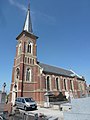
Saint-Jean-Baptiste church

Windmills
_%C3%A9glise_Saint-Jean-Baptiste_(02).JPG)
_moulin_%C3%A0_vent_(03).JPG)
Personalities
- Marie Duhem (1871–1918), painter
Web links
Individual evidence
- ^ De Nederlanden in Frankrijk, Jozef van Overstraeten, 1969