Bouquehault
| Bouquehault | ||
|---|---|---|

|
|
|
| region | Hauts-de-France | |
| Department | Pas-de-Calais | |
| Arrondissement | Calais | |
| Canton | Calais-2 | |
| Community association | Pays d'Opale | |
| Coordinates | 50 ° 50 ′ N , 1 ° 54 ′ E | |
| height | 44-181 m | |
| surface | 8.04 km 2 | |
| Residents | 765 (January 1, 2017) | |
| Population density | 95 inhabitants / km 2 | |
| Post Code | 62340 | |
| INSEE code | 62161 | |
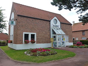
 Town Hall (Mairie) in Bouquehault |
||
Bouquehault is a French municipality with 765 inhabitants (as of January 1 2017) in the department of Pas-de-Calais in the region of Hauts-de-France ; it belongs to the Arrondissement of Calais and the canton of Calais-2 (until 2015: canton of Guînes ).
geography
Bouquehault is about 14 kilometers south-southeast of Calais . The municipality is part of the Caps et Marais d'Opale Regional Nature Park .
Bouquehault is surrounded by the neighboring communities of Campagne-lès-Guines in the north, Rodelinghem in the east and northeast, Licques in the east and southeast, Alembon in the south, Hermelinghen in the west and southwest and Guînes in the west and northwest.
Population development
| year | 1962 | 1968 | 1975 | 1982 | 1990 | 1999 | 2006 | 2013 |
|---|---|---|---|---|---|---|---|---|
| Residents | 452 | 480 | 450 | 488 | 529 | 567 | 663 | 719 |
| Source: Cassini and INSEE | ||||||||
Attractions
- Saint-Omer church from the 16th century
- Dippendal Castle from the 19th century
- Remains of the former castle
- Ruins of the windmill from 1868
Web links
Commons : Bouquehault - collection of images, videos and audio files

