Les Attaques
| Les Attaques | ||
|---|---|---|

|
|
|
| region | Hauts-de-France | |
| Department | Pas-de-Calais | |
| Arrondissement | Calais | |
| Canton | Calais-2 | |
| Community association | Calaisis | |
| Coordinates | 50 ° 54 ' N , 1 ° 56' E | |
| height | 0-6 m | |
| surface | 20.81 km 2 | |
| Residents | 1,978 (January 1, 2017) | |
| Population density | 95 inhabitants / km 2 | |
| Post Code | 62730 | |
| INSEE code | 62043 | |
| Website | http://www.lesattaques.fr/ | |
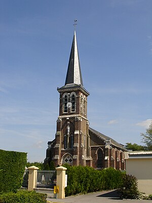
 Saint-Pierre-ès-Liens church |
||
Les Attaques is a French commune with a population of 1,978 (as at 1st January 2017) in the department of Pas-de-Calais in the region of Hauts-de-France . It belongs to the Arrondissement of Calais and the canton of Calais-2 (until 2015: canton of Calais-Center ).
geography
Les Attaques is a banlieue seven kilometers southeast of Calais on the Canal de Calais . Les Attaques is surrounded by the neighboring communities of Marck in the north, Guemps in the east and northeast, Ardres in the southeast, Balinghem and Andres in the south, Guînes in the southwest, Hames-Boucres in the west and southwest and Coulogne in the west and northwest.
The A26 autoroute runs through the municipality .
Population development
| year | 1962 | 1968 | 1975 | 1982 | 1990 | 1999 | 2006 | 2012 |
|---|---|---|---|---|---|---|---|---|
| Residents | 1,807 | 1,790 | 1,775 | 1,878 | 1,887 | 1,821 | 1.961 | 1.939 |
| Source: Cassini and INSEE | ||||||||
Culture and sights
- Saint-Pierre-ès-Liens church
- bridge
Web links
Commons : Les Attaques - collection of images, videos and audio files
