
Landrethun-lès-Ardres
| Landrethun-lès-Ardres | ||
|---|---|---|

|
|
|
| region | Hauts-de-France | |
| Department | Pas-de-Calais | |
| Arrondissement | Calais | |
| Canton | Calais-2 | |
| Community association | Pays d'Opale | |
| Coordinates | 50 ° 50 ′ N , 1 ° 58 ′ E | |
| height | 34-171 m | |
| surface | 5.71 km 2 | |
| Residents | 753 (January 1, 2017) | |
| Population density | 132 inhabitants / km 2 | |
| Post Code | 62850 | |
| INSEE code | 62488 | |
| Website | http://landrethun-lez-ardres.fr/ | |
_mairie.JPG) Town hall (Mairie) of Landrethun-lès-Ardres |
||

Landrethun-lès-Ardres ( Flemish : Landerten ) is a municipality in northern France with 753 inhabitants (as of January 1, 2017). It belongs to the Hauts-de-France region , the Nord department , the Calais arrondissement and the Calais-2 canton (until 2015: Ardres canton ).
geography
Landrethun-lès-Ardres is about twenty kilometers north-west of Saint-Omer and borders on Brêmes in the north and north-west, Louches in the north and east, Clesques in the south-east, Licques in the south and south-west and Rodelinghem in the west and north-west. The municipality is part of the Caps et Marais d'Opale Regional Nature Park .
Population development
| year | 1962 | 1968 | 1975 | 1982 | 1990 | 1999 | 2006 | 2013 |
|---|---|---|---|---|---|---|---|---|
| Residents | 451 | 414 | 399 | 469 | 568 | 599 | 671 | 730 |
| Source: Cassini and INSEE | ||||||||
Attractions
- 19th century Saint Martin church
- Chapel of Yeuse
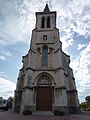
Saint Martin Church

Chapel of Yeuse
_%C3%A9glise,_la_tour.JPG)

Web links
Commons : Landrethun-lès-Ardres - Collection of images, videos and audio files