Ruminghem
| Ruminghem | ||
|---|---|---|

|
|
|
| region | Hauts-de-France | |
| Department | Pas-de-Calais | |
| Arrondissement | Calais | |
| Canton | Marck | |
| Community association | Région d'Audruicq | |
| Coordinates | 50 ° 52 ′ N , 2 ° 10 ′ E | |
| height | 1-64 m | |
| surface | 13.89 km 2 | |
| Residents | 1,650 (January 1, 2017) | |
| Population density | 119 inhabitants / km 2 | |
| Post Code | 62370 | |
| INSEE code | 62730 | |
| Website | http://ruminghem.fr/ | |
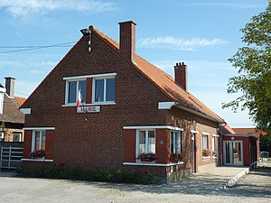
 Ruminghem Town Hall |
||
Ruminghem ( Dutch : Rumingem ) is a French municipality with 1,650 inhabitants (as of January 1 2017) in the department of Pas-de-Calais in the region of Hauts-de-France . It has belonged to the Arrondissement of Calais (previously Saint-Omer ) and the Canton of Marck (until 2015: Canton Audruicq ) since 2017 . The inhabitants are called Ruminghemois .
geography
Ruminghem is about 23 kilometers southeast of Calais . The municipality is part of the Caps et Marais d'Opale Regional Nature Park . The municipality is bounded by the Canal de Calais to the north and the Aa canalised river to the east . Ruminghem is surrounded by the neighboring communities of Sainte-Marie-Kerque in the north, Saint-Pierre-Brouck in the northeast, Holque in the east, Éperlecques in the south and Muncq-Nieurlet in the west.
| Population development | ||||||||
|---|---|---|---|---|---|---|---|---|
| year | 1962 | 1968 | 1975 | 1982 | 1990 | 1999 | 2006 | 2013 |
| Residents | 1.012 | 968 | 927 | 1,019 | 1,120 | 1,163 | 1,427 | 1,640 |
| Source: Cassini and INSEE | ||||||||
Attractions
- Saint-Martin church from 1806
- former windmill, now near Villeneuve-d'Ascq
- Chinese cemetery
Web links
Individual evidence
- ^ De Nederlanden in Frankrijk, Jozef van Overstraeten, 1969

