Hermelinghen
| Hermelinghen | ||
|---|---|---|

|
|
|
| region | Hauts-de-France | |
| Department | Pas-de-Calais | |
| Arrondissement | Calais | |
| Canton | Calais-2 | |
| Community association | Pays d'Opale | |
| Coordinates | 50 ° 48 ′ N , 1 ° 52 ′ E | |
| height | 95-185 m | |
| surface | 6.43 km 2 | |
| Residents | 422 (January 1, 2017) | |
| Population density | 66 inhabitants / km 2 | |
| Post Code | 62132 | |
| INSEE code | 62439 | |
 Town hall (Mairie) in Hermelinghen |
||
Hermelinghen ( Flemish : Hermel Ingen ) is a French municipality with 422 inhabitants (as of January 1 2017) in the department of Pas-de-Calais in the region of Hauts-de-France ; it belongs to the Arrondissement of Calais and the canton of Calais-2 (until 2015: canton of Guînes ).
geography
Hermelinghen is about 16 kilometers south of Calais . The municipality is part of the Caps et Marais d'Opale Regional Nature Park .
Hermelinghen is surrounded by the neighboring communities of Fiennes in the north and northwest, Guînes in the north, Bouquehault in the east and northeast, Alembon in the south and southeast and Hardinghen in the west.
history
During the Battle of Britain a field airfield of the German Air Force was located near Hermelinghen , which was used from August to September 1940 by the Bf 109E of Group II of Jagdgeschwader 54 .
Population development
| year | 1962 | 1968 | 1975 | 1982 | 1990 | 1999 | 2006 | 2013 |
|---|---|---|---|---|---|---|---|---|
| Residents | 208 | 211 | 217 | 263 | 288 | 289 | 302 | 360 |
| Source: Cassini and INSEE | ||||||||
Attractions
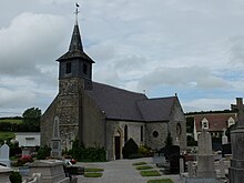
- Sainte-Agathe church from the 18th century
- Remains of the old castle ruins
Web links
Individual evidence
- ^ De Nederlanden in Frankrijk, Jozef van Overstraeten, 1969

