Zutkerque
| Zutkerque | ||
|---|---|---|

|
|
|
| region | Hauts-de-France | |
| Department | Pas-de-Calais | |
| Arrondissement | Calais | |
| Canton | Marck | |
| Community association | Région d'Audruicq | |
| Coordinates | 50 ° 51 ′ N , 2 ° 4 ′ E | |
| height | 3–55 m | |
| surface | 16.41 km 2 | |
| Residents | 1,753 (January 1, 2017) | |
| Population density | 107 inhabitants / km 2 | |
| Post Code | 62370 | |
| INSEE code | 62906 | |
| Website | http://zutkerque.free.fr site | |
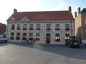
 Mairie Zutkerque |
||
Zutkerque (NDL .: Zuidkerke ) is a French municipality with 1753 inhabitants (at January 1, 2017) in the department of Pas-de-Calais in the region of Hauts-de-France . It has belonged to the Arrondissement of Calais (previously Saint-Omer ) and the canton of Marck since 2017 .
In addition to Zutkerque itself, the districts of Zutkerque include Blanc Pignon, Grasse Payelle, Listergaux and Ostove. The neighboring communities of Zutkerque are Nortkerque (ndl .: Noordkerke ) and Audruicq in the north, Polincove (ndl .: Pollinkhove ) in the east, Recques-sur-Hem (ndl .: Rekke aan de Hem ) in the southeast, Tournehem-sur-la-Hem (ndl .: Doornem ) and Zouafques (ndl .: Zwaveke ) in the south, Louches (ndl .: Lotesse ) in the southwest, Nielles-lès-Ardres (ndl .: Niel bij Aarde ) in the west and Ardres (ndl .: Aarde ) in the north-west.
Population development
| year | 1962 | 1968 | 1975 | 1982 | 1990 | 1999 | 2007 | 2016 |
| Residents | 1,291 | 1,293 | 1,308 | 1,553 | 1,723 | 1,711 | 1,712 | 1,742 |
Attractions
- Saint Martin Church
- Draëck Castle (1707)
Web links
Individual evidence
- ^ De Nederlanden in Frankrijk, Jozef van Overstraeten, 1969

