
Hamm-Rhynern
| coat of arms | map |
|---|---|

|

|
| Basic data | |
| State : | North Rhine-Westphalia |
| Administrative region : | Arnsberg |
| Regional association : | Westphalia-Lippe |
| Regional Association Ruhr | |
| Circle : | District of the independent city of Hamm |
| Geographic location : | 51 ° 38 ′ N , 7 ° 51 ′ E |
| Height : | 92.96 m above sea level NN |
| Area : | 59.22 km² |
| Incorporation of Rhynerns: | 1st January 1975 |
| Postal code : | 59069 |
| Primaries : | 02381, 02383, 02384, 02385 |
| License plate : | HAM |
| District structure: | Subdistricts |
| Address of the district representative: |
Unnaer Str. 12 59069 Hamm |
| politics | |
| District Head : | Brigitte Sosna ( CDU ) |
| population | |
| Residents : | 18,225 (as of December 31, 2017) |
| Population density : | 305 inhabitants per km² |
| Proportion of foreigners : | 3.6% (December 31, 2017) |


Hamm-Rhynern [ ˈriːnɐn ] is with 59.22 km² the largest district of the city of Hamm in Westphalia . It has 18,225 inhabitants and thus a population density of 305 inhabitants per km². The place is predominantly rural and agricultural.
geography
location
Rhynern is located in the heart of Westphalia on the south side of the Lippe . Its coordinates based on the old village church be 51 ° 37 '47.8 " N , 7 ° 51' 29.2" O , it is calibrated with 92,96 m above sea level. NN . This southeastern district of Hamm is bounded in the east by the municipality of Welver , in the south by the city of Werl , both districts of Soest . In the west, the city of Unna and the municipality of Bönen , both district of Unna , and the district of Pelkum join. To the north, Rhynern is bordered by the districts of Mitte and Uentrop .
Districts
The following districts and districts belong to the Rhynern district:
- Rhynern
- mountains
- Westtünnen
- Caldenhof
- Osttünnen
- Süddinker
- Everyone
- Under all
- Zengerott
- Wobble
- Wambeln fracture
- Opsen
- Freiske
- Turning
- Osterflierich
- Pedinghausen
- Mate
history
The oldest written mention of Rhynern as Rhineri can be found in a manuscript dated around the year 1000, which is in the Münster State Archives . In 1302, the Officium Rinhere came as a pledge from the possession of the bishops of Münster into the possession of the Counts of the Mark and was no longer redeemed. During the French occupation in the 19th century, the office of Rhynern was established as Mairie in 1808. After the restoration of the Prussian Westphalia as the province of Westphalia, it remained.
As early as April 1, 1939, the village of Mark was spun off from office and largely incorporated into Hamm. On January 1, 1968, Rhynern became the municipality of Rhynern. However, this only lasted until December 31, 1974, from the following day onwards it was divided: 6187 residents, who lived on 44.79 km 2 , moved to Hamm. The Hilbeck district (9.96 km 2 with 856 inhabitants) was reclassified to Werl .
politics
District Representation
coat of arms
After the founding of the large community of Rhynern, it was given a coat of arms in 1969. Based on the coat of arms of the Counts von der Mark (sovereigns since 1302) and the County of Mark, this shows the only two-row chessboard bar in red and silver on a gold field, above the three red circles of the local noble family of the von Pentling-Hilbeck family and in the lower one Third the red bar of the duchy of Münster, to which the area belonged before 1302. In addition to Hamm-Mitte, which bears the coat of arms of Hamm, Rhynern is the only district whose coat of arms corresponds at least in part to the city coat of arms of Hamm.
Public facilities
In the city district are
- the vocational support organization (rehabilitation center)
- the south outdoor pool
- a district library of the Hamm City Libraries
- a police station
- a youth center
- three elementary , one secondary and one secondary school
- the tennis club Blau-Weiß Rhynern with eight courts
- a sports field Papenloh with a 400 meter running track (SV Westfalia Rhynern eV)
- a training center (natural turf sports field) (synthetic turf sports field - Liga-Turf brand) of SV Westfalia Rhynern eV
- a triple sports hall (Konrad-Adenauer-Sporthalle) of SV Westfalia Rhynern eV
- a sports hall at the former secondary school of SV Westfalia Rhynern eV
- the Rhynern Evangelical Church
- Catholic Church of St. Regina
traffic

The A 2 with the Hamm junction and the B 63 run through Rhynern . There is a connection to the German rail network via Hamm main station and the Welver stop on the Hamm – Warburg railway line . Rhynern is indirectly connected to the German waterway network via the Uentrop canal end port and the Hamm city port . In local transport, the city district is connected to the city of Hamm's bus network.
economy
There is a commercial and industrial area in the city district. The companies EDEKA and Netto, which maintain logistics centers here, are to be mentioned as larger settlements. Successful medium-sized companies are also represented, such as Munk GmbH, a manufacturer of power supply systems for surface coating, and FINK TEC, which produces cleaning agents and disinfectants. A steel trading center is also located.
Views

Listed building near St. Regina
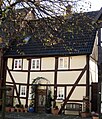
Listed half-timbered house near St. Regina


Web links
- Hamm-Rhynern in the Westphalia Culture Atlas
Individual evidence
- ^ Rhynern district | City of Hamm. Retrieved July 13, 2020 .
- ↑ Stephanie Reekers: The regional development of the districts and communities of Westphalia 1817-1967 . Aschendorff, Münster (Westphalia) 1977, ISBN 3-402-05875-8 .
- ↑ Martin Bünermann: The communities of the first reorganization program in North Rhine-Westphalia . Deutscher Gemeindeverlag, Cologne 1970, p. 64 .
- ↑ Martin Bünermann, Heinz Köstering: The communities and districts after the municipal territorial reform in North Rhine-Westphalia . Deutscher Gemeindeverlag, Cologne 1975, ISBN 3-555-30092-X , p. 125, 149 .

Hamm-Bockum-Hövel (with Bockum , Hövel and the western part of Hamm-Norden )
Hamm-Heessen (with Heessen and the eastern part of Hamm-Norden )
Hamm-Herringen (with Herringen and Sandbochum )
Hamm-Mitte
Hamm-Pelkum ( with Lerche , Pelkum , Weetfeld and Wiescherhöfen )
Hamm-Rhynern (with Allen , Berge , Freiske , Osterflierich , Osttünnen , Rhynern , Süddinker , Wambeln and Westtünnen )
Hamm-Uentrop (with Braam-Ostwennemar , Frielinghausen , Haaren , Mark , Norddinker , Schmehausen , Uentrop , Vöckinghausen and Werries )