
Hamm-Heessen
| coat of arms | map |
|---|---|

|

|
| Basic data | |
| State : | North Rhine-Westphalia |
| Administrative region : | Arnsberg |
| Regional association : | Westphalia-Lippe |
| Regional Association Ruhr | |
| City district : | independent city of Hamm |
| Geographic location : | 51 ° 43 ′ N , 7 ° 50 ′ E |
| Height : | 70.1 m above sea level NN |
| Area : | 29.23 km² |
|
Incorporation of the city of Heessen: |
1st January 1975 |
| Postal code : | 59065, 59073 |
| Primaries : | 02381, 02382 |
| License plate : | HAM |
| District structure: | Subdistricts: Nordenfeldmark-Ost, Mattenbecke, Zeche-Sachsen, Heessener Gartenstadt, Heessener Dorf, Westhusen, Dasbeck, Frielick |
| Address of the district representative: |
Amtsstrasse 19 59073 Hamm |
| politics | |
| District Head : | Erzina Brennecke ( SPD ) |
| population | |
| Residents : | 23,886 (as of December 31, 2017) |
| Population density : | 817 inhabitants per km² |
| Proportion of foreigners : | 19.6% (December 31, 2017) |
Hamm-Heessen is a district of the independent city of Hamm . It consists of the Heessen district and the eastern part of the former Hamm-Norden district .
geography
location
Heessen is located in Westphalia , north of the Lippe and in the southern Münsterland. In the south Heessen borders on Hamm-Uentrop and Hamm-Mitte, in the west on Hamm-Bockum-Hövel . In the north, the city of Ahlen joins the Warendorf district with its Dolberg district . Heessen and the neighboring district of Bockum-Hövel are the only areas of Hamm that, apart from the respective area of Hamm-Norden, are also included in the historical and geographical region of Münsterland .
Landscape image
With over 800 inhabitants / km² Heessen has a comparatively high population density, which is well above the national average. It is even slightly higher than that of the entire city of Hamm.
The Heessens area is around 80 meters above sea level. NN; to the south towards the Lippe, the terrain drops slightly to around 60 meters above sea level. NN. Roughly three rooms can be distinguished:
- 1. In the south in the course of the Lippe, Heessen has a share in the Lippewiesen, a roughly 500 meter wide and four kilometer long lowland, which consists almost exclusively of grassland and has no large settlements. Large areas of this wetland are under nature protection. Part of this area is used as the Hamm-Lippewiesen airfield. Heessen Castle is also located here. The Lippe meanders through this valley , and the Datteln-Hamm Canal runs parallel to the south .
- 2. The actual settlement of Heeßen is located in the center and south-west of the district area and covers around 5 km². This is where most of the population lives, which results in an average population density of around 4,500 people / km². To the south-west, the development in Heessen merges almost seamlessly into the Bockum-Hövels and the Hammer Center.
- Although Heessen has an extensive and quite extensive economic center appropriate to the size of the former city, with supermarkets, department stores and restaurants, it only has a fairly manageable real historical core, which is called Alt-Heeßen and consists of several half-timbered houses.
- The townscape shows only a few old courtyards from the time when this core area was also still structured in a rural way. Buildings that offer living space in a small area predominate. It is noticeable that prefabricated building districts (as in the course of Asternstrasse) are in close proximity to districts with single-family houses (as in the Dasbek area). In the older core area in particular, Heessen does not look like a small town in the Munsterland, but rather has the flair of a Ruhr area town with its typical little booths and gray tenements. Sometimes there are natural areas in the densely populated central area, e.g. B. the cap bush .
- 3. Large parts of the north and east of the Heessen district, a foothills of the Lipper heights , are hardly populated and, in addition to large agricultural areas, also have extensive forests, e.g. For example, the 55 hectare Ostbusch in the northwest between Dasbeck and Münsterstrasse or the extensive Frielicker Holz in the far north, whose forest area in the Heessens area alone measures around 165 hectares and extends further north into the Münsterland beyond the city limits. Parts of these forests are under nature protection, such as the 35 hectare Heessener Wald , east of the Waldbühne. In contrast to the Lippe meadows, the agricultural areas are predominantly arable land. The area north and west of the closed development in Heessen covers around 13 km² and has just under 400 inhabitants, which corresponds to an average population density of around 30 people / km². There are hardly any closed larger villages here (except for Westhusen and Frielick). The building sites are (possibly former) individual farms, including riding stables, etc. This agricultural north and east of Heessen does not differ in a certain way from the Münsterland, it is almost an ideal typical part of it.
- With around 150 hectares, the former military training area takes up a not inconsiderable part of the rural north. The training area and the on-site shooting range belonged to the Bundeswehr property in Ahlen , but in contrast to the barracks itself, it is located entirely in Heessen.
history
Heessen was mentioned for the first time in 975 and belonged to the Prince Diocese of Münster . Within the diocese of the Office Wolbeck assigned, it was the 1816 mayoralty Ahlen circle Beckum incorporated. Test drillings for coal had been carried out as early as 1903, which led to the establishment of the Sachsen colliery in 1911 . With the start of the sinking work in 1912 and the subsequent coal mining in 1914 at the Sachsen colliery, the population rose rapidly from around 3,000 at that time.
After Heessen had already formed its own office from 1858 to 1864 , it became the seat of the Ahlen office in 1914 , which was then renamed the Heessen office . In 1921 this office was divided into the Ahlen office , consisting of Altahlen , Dolberg and Neuahlen , and the Heessen office , consisting of the municipality of Heessen.
On December 3, 1917, an express train and a train carrying prisoners of war collided at Heessen station . 32 people died, 87 were also injured.
The Heessen office was abolished in 1934. Since then Heessen has been an unofficial community. The small rural village developed into an industrial community and was awarded the status of a town in the then Beckum district by the state of North Rhine-Westphalia on April 28, 1964. This was incorporated into the city of Hamm on January 1, 1975. This year Heessen had almost 19,500 inhabitants on 24.39 km². Just one year later, the Saxony mine was shut down.
politics
District Representation
coat of arms
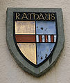
In the absence of a historical coat of arms, the coat of arms was created in 1929 and awarded to the municipality. The municipality and later town of Heessen managed it until it was dissolved on January 1, 1975. Since then it has been used by the municipality of Heessen. It shows a red bar in the split shield in front in gold (yellow) , symbolic of the Münsterland and the long membership of the Principality of Münster . The rear field shows a silver (white) bar covered with three red stakes in blue , and represents the von der Recke family , who lived in Heessen Castle from the 15th century to 1778 .
Heessen's coat of arms on the former town hall, today's district and citizens' office

Coat of arms of the Principality of Münster

Coat of arms of the von der Recke family


Attractions

- Heessen Castle , today a private school with boarding school
- Oberwerries Castle , seat of the Westphalian Gymnastics Federation
- The listed St. Anna Chapel
- The double-towered catholic church, inaugurated in 1876. St. Stephen's Church
- The Church of St. Mary
- Waldbühne Heessen , one of the largest amateur open-air stages in Germany
particularities
- Dreigipfelige Halde Sachsen next to the colliery area
- Ökozentrum NRW, on the site and in the buildings of the Zeche Sachsen
economy
Major employers and companies in the municipality are:
- St. Barbara Clinic
(with the specialist departments: internal medicine, nephrology and dialysis, pulmonology, infectiology and sleep laboratory, general surgery, trauma surgery, hand surgery, neurosurgery and stereotaxic, gynecology and obstetrics, anesthesia, ENT, ophthalmology)
- St. Stephanus retirement home
Public facilities
Today there are five primary schools, two secondary schools, a secondary school and a grammar school (private school Schloss Heessen) as well as a special school in the district.
- Brokhof meeting place
- Heessen district library of the Hamm city libraries
- Educational institution of the city of Hamm at Oberwerries Castle
- Heessen volunteer fire brigade
- Heessen indoor swimming pool
- Bockelweg Youth Center
- Municipal support center for educational assistance
- Eco center NRW
- Police station Heessen
- Sachsenhalle
- St. Barbara Clinic Heessen.
traffic
Heessen is connected to the German trunk road network by the Münsterstrasse B 63 and the B 61 . The federal highway 63, which connects Hamm and Münster, crosses Heessen on the border to Bockum-Hövel . The next motorway junction is Hamm-Uentrop (19) on the A 2 . Which is a feeder road on the north A1 to achieve. Heessen is indirectly connected to the waterway network via the Hamm city harbor and the Uentrop canal end harbor. The Hamm airfield is also located in the Lippewiesen .

The Hamm-Heessen stop is on the Hamm – Minden railway line . It is served every hour by the regional express RE 6 " Westfalen-Express " and the regional train RB 69 " Ems-Börde-Bahn ", so that there is a total of every half hour. The RE 6 line is operated by National Express , the RB 69 line by the Eurobahn .
In 2009, over 600,000 euros were made available for the renovation of the station.
Sons and Daughters of the Borough
- Matthäus Tympius (1566–1616), German theologian, educator and writer
- Heinrich Horstmann (1874–1945), German cyclist and author
- Josef Veldtrup (1907–1987), educator and poet
- Walter Arendt (1925–2005), from 1964 to 1969 chairman of the IG Bergbau und Energie; from 1961 to 1980 Member of the Bundestag (SPD); from 1969 to 1976 Federal Minister for Labor and Social Affairs
- Hans-Jürgen Sperlich (* 1948), football player
- Christoph Wenzel (* 1979), writer and editor
- Dženis Burnić (* 1998), football player
literature
- Wolfgang Gernert: Heessen - gateway to the Münsterland. Artcolor publishing house.
- Stefan Klönne: Radbod. Hammer mines through the ages. Thesis at the Westfälische Wilhelms-Universität Münster, Münster 2000.
- Gisela Wallgärtner: Heessen and the colliery Saxony 1912–1976. Klartext Verlag.
- Hans-Hermann Buchhorn: Heessen.
Web links
- Independent information and communication portal for Heessen
- Hamm-Heessen in the Westphalia Culture Atlas
Individual evidence
- ↑ HIS-Data Office Heessen
- ^ A b Wolfgang Leesch: Administration in Westphalia 1815–1945 . In: Publications of the Historical Commission for Westphalia . tape 38 . Aschendorff, Münster 1992, ISBN 3-402-06845-1 .
- ^ Hans Joachim Ritzau: Railway disasters in Germany. Splinters of German history . Vol. 1: Landsberg-Pürgen 1979, p. 79.
- ↑ Stephanie Reekers: The regional development of the districts and communities of Westphalia 1817-1967 . Aschendorff, Münster Westfalen 1977, ISBN 3-402-05875-8 , p. 242 .
- ↑ Martin Bünermann, Heinz Köstering: The communities and districts after the municipal territorial reform in North Rhine-Westphalia . Deutscher Gemeindeverlag, Cologne 1975, ISBN 3-555-30092-X , p. 125 .
- ↑ Hammwiki, as of 2014

Hamm-Bockum-Hövel (with Bockum , Hövel and the western part of Hamm-Norden )
Hamm-Heessen (with Heessen and the eastern part of Hamm-Norden )
Hamm-Herringen (with Herringen and Sandbochum )
Hamm-Mitte
Hamm-Pelkum ( with Lerche , Pelkum , Weetfeld and Wiescherhöfen )
Hamm-Rhynern (with Allen , Berge , Freiske , Osterflierich , Osttünnen , Rhynern , Süddinker , Wambeln and Westtünnen )
Hamm-Uentrop (with Braam-Ostwennemar , Frielinghausen , Haaren , Mark , Norddinker , Schmehausen , Uentrop , Vöckinghausen and Werries )