
Haselbach (near Altenburg)
| coat of arms | Germany map | |
|---|---|---|
 Help on coat of arms |
Coordinates: 51 ° 4 ′ N , 12 ° 26 ′ E |
|
| Basic data | ||
| State : | Thuringia | |
| County : | Altenburger Land | |
| Management Community : | Pleißenaue | |
| Height : | 155 m above sea level NHN | |
| Area : | 2.76 km 2 | |
| Residents: | 800 (Dec. 31, 2019) | |
| Population density : | 290 inhabitants per km 2 | |
| Postal code : | 04617 | |
| Area code : | 034343 | |
| License plate : | ABG, SLN | |
| Community key : | 16 0 77 015 | |
| Address of the municipal administration: |
Altenburger Strasse 17 04617 Haselbach |
|
| Website : | ||
| Mayor : | Eckhard Gilge ( CDU ) | |
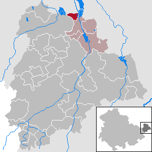
| Location of the community Haselbach in the Altenburger Land district | ||
  |
||

Haselbach is a municipality in the Altenburger Land district in Thuringia . It belongs to the Pleißenaue administrative community and is part of the Leipziger Neuseenland . The lignite industry shaped the place, especially due to the sudden increase in population. At the beginning of the 2000s the population was relatively stable.
geography
To the east of Haselbach is the Regis-Serbitz flood retention basin , which can dam the Pleiße . There are also eight of the sixteen Haselbacher ponds in the municipality , which are fed by the Gerstenbach and have a water surface of 56.6 hectares. In addition, the Haselbacher See, which was flooded from 1993 to 1999 and formed from a remaining open pit, still exists . The partially slightly wavy relief of the community is the result of the upheaval around 1910 to 1920.
Neighboring communities
Neighboring communities are Treben and Meuselwitz in the Altenburger Land district and the city of Regis-Breitingen in the Leipzig district in Saxony .
history
13th to 19th centuries

Haselbach was first mentioned in a document in 1282. Despite the German place name, it is assumed that a Sorbian village was founded, the most typical object, the Rundling . The place was the seat of a manor, its owner from 1521, Burgrave Hugo von Leißnig , initiated the creation of the Haselbacher ponds for fish farming, 16 in number, not to be confused with the Haselbacher See . The place burned down almost completely in the Thirty Years War . In 1804 a wool spinning mill was built on the largest of these waters.
Haselbach belonged to the Wettin office of Altenburg , which from the 16th century was under the sovereignty of the following Ernestine duchies due to several divisions during its existence : Duchy of Saxony (1554 to 1572), Duchy of Saxony-Weimar (1572 to 1603), Duchy of Saxony-Altenburg (1603 to 1672), Duchy of Saxony-Gotha-Altenburg (1672 to 1826). When the Ernestine duchies were reorganized in 1826, the place came back to the duchy of Saxony-Altenburg. After the administrative reform in the duchy, it belonged to the eastern district (until 1900) and to the Altenburg district office (from 1900).
Lignite mining in the Central German District began in 1867.
20th century to the present

In 1908 a briquette factory was built, which was demolished in 1992, and the pottery industry, which still exists today, was created because the mining waste contained high-quality clays; in 1941, 234,000 tons were processed. From 1918 Haselbach belonged to the Free State of Saxony-Altenburg , which was added to the State of Thuringia in 1920. In 1922 the place came to the district of Altenburg .
In the camps "Haselbach II" (occupied with 124 people) and "Haselbach IV" (42 people) forced laborers for the smoldering plant Regis-Breitingen and the Nordmann company were housed.
During the second district reform in the GDR in 1952, the existing states were dissolved and the districts were redesigned. Thus Haselbach came with the district Altenburg to the district of Leipzig . In 1954, the opening of the Haselbach III opencast mine , the last lignite opencast mine in the Altenburger Land, began, and in 1957 the first coal was mined. It was in operation until 1977. This was followed by reforestation and the flooding of the remaining hole from which the Haselbacher See emerged.
With the re-establishment of the Free State of Thuringia in 1990, Haselbach came to the Thuringian district of Altenburg, which was merged into the district of Altenburger Land in 1994. Since 1991 the place belongs to the administrative community Pleißenaue .
Development of the population
|
|
|
|
|
- Data source from 1994: Thuringian State Office for Statistics, on December 31st

politics
mayor
Mayor was Dagmar Köster from 1994 to 1999. From 1999 to 2001 the FDP politician Uwe Köhler held the office of mayor. The CDU politician Hans-Joachim Ignasiak was the incumbent from 2001 to 2010. The 2010 election was won by the CDU politician Eckhard Gilge and was confirmed in office on June 5, 2016 with a majority of 98.6% and a turnout of 42.5 (+ 2.7% p).
Municipal council
Since the local elections on May 25, 2014 , the local council has been composed as follows:
The turnout was 45.0% (+ 0.4%).
In the community center, which houses the municipal office, there is also a doctor's practice and a youth club.
Culture
First and foremost, the Haselbacher See should be mentioned as a local recreation area. There is also a sports facility with a bowling alley. There is a public playground at the kindergarten. Furthermore, the place has a stop on the coal railway to Meuselwitz ("Kammerforstbahn", today a museum railway).

Economy and Infrastructure
Although the section from Leipzig to Altenburg of the Leipzig – Hof railway line runs through the town, it does not have its own stopping point . The next stops are Regis-Breitingen in the north and Treben - Lehma in the south. The municipality holds an industrial park with a metal construction company and a building renovation company.
Personalities
- Walter Busch (1932–2020), veterinarian
Individual evidence
- ^ Population of the municipalities from the Thuringian State Office for Statistics ( help on this ).
- ^ The Altenburg Office in the book "Geography for all Stands", from p. 201
- ^ The locations of the Altenburg district from p.83
- ↑ The eastern district of the Duchy of Saxony-Altenburg in the municipal directory 1900
- ^ The Altenburg district office in the municipality register 1900
- ↑ Thuringian Association of the Persecuted of the Nazi Regime - Association of Antifascists and Study Group of German Resistance 1933–1945 (Ed.): Local history guide to sites of resistance and persecution 1933–1945. Local history guide, Volume 8: Thuringia. Erfurt 2003, ISBN 3-88864-343-0 .
- ↑ Results of the mayoral elections on the website of the Regional Returning Officer Thuringia , accessed on July 31, 2016
Web links
Altenburg | Dobitschen | Fockendorf | Gerstenberg | Goehren | Göllnitz | Göpfersdorf | Gößnitz | Haselbach | Heukewalde | Heyersdorf | Jonaswalde | Kriebitzsch | Langenleuba-Niederhain | Löbichau | Lödla | Lucka | Mehna | Meuselwitz | Monstrous | Nobitz | Ponitz | Poster stone | Rositz | Schmölln | Starkenberg | Thonhausen | Treben | Vollmershain | Windischleuba