
Heeren (Stendal)
|
Armies
City of Stendal
Coordinates: 52 ° 32 ′ 31 ″ N , 11 ° 53 ′ 20 ″ E
|
||
|---|---|---|
| Height : | 46 m | |
| Area : | 13.54 km² | |
| Residents : | 583 (December 31, 2008) | |
| Population density : | 43 inhabitants / km² | |
| Incorporation : | January 1, 2010 | |
| Postal code : | 39576 | |
| Area code : | 03931 | |
Location in Saxony-Anhalt |
||

Heeren is a district of the district town of Stendal in Saxony-Anhalt (Germany).
geography
The village of Heeren is located at an average altitude of 39 meters above sea level between Uchte , Tanger and Elbe , only five kilometers from the cities of Stendal and Tangermünde .
history
The name of the place is of German origin and could go back to here , which would mean something like sandy mountain range . The place is first mentioned in a document in 1203. The Romanesque village church of Heeren is even a little older and dates from the second half of the 12th century. Until 1238, Heeren belonged to the Count of Osterburg and Altenhausen. Presumably as early as the 13th century, however, the village was divided into eastern and western armies. The church was shared. In Ostheeren there was a manor belonging to the von Alvensleben family. While in Ostheeren the mayor was later elected by the citizens, in Westheeren the office of Lehnschulzen existed . The office of mayor was inherited there.
On April 24, 1858, a fire broke out on the Lühe farm in Ostheeren. Due to the existing westerly wind, the fire spread to other farms, a total of twelve farms burned down. Eastern armies were largely destroyed. As a punishment, the Lühe farm was not allowed to be rebuilt at its original location. This created an open space in the village, today's monument square .
On April 1, 1935, the rural communities Ostheeren and Westheeren were merged to form the municipality of Heeren.
At the beginning of the 20th century, due to good success in animal breeding , there was a parent breeding cooperative in Heeren .
To commemorate the dead of the First World War , a war memorial was erected on the present memorial square after 1918 . The boulder carved for this purpose came from Schernbeckhof and weighs around 35 tons. In 1937 Friedrich Vinzelberg founded the vegetable growing business in the GDR , which belonged to VEG Uenglingen from August 1952 to the end of 1954 and was run independently as VEG-Gartenbau Heeren from 1955 . In addition, the LPG Free Land existed from April 13, 1953 . The two companies were the determining economic factors of the village until 1990.
Heeren was an independent municipality until December 31, 2009. On June 18, 2009, the Heeren municipal council decided to incorporate the Heeren municipality into the city of Stendal by means of an agreement to change the area . The contract was approved by the county as the lower local supervisory authority and came into effect on January 1, 2010.
After the incorporation, Heeren became part of the city of Stendal. For Heeren the local constitution was introduced according to §§ 86 ff. Of the municipality code of Saxony-Anhalt . Heeren thus became the locality of the receiving city of Stendal. In what is now the village of Heeren, a local council with six members including the local mayor was formed.
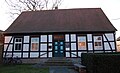
Former Heeren municipal office
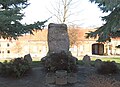
War memorial in Heeren

Heeren village church


politics
mayor
The last mayor of the municipality of Heeren was Wolfgang Eckhardt.
Economy and Infrastructure
In addition to agriculture, a concrete block factory shapes the image of Heeren. There is also a small retail shop in the village.
Country roads lead from Heeren to Stendal, Tangermünde and Tangerhütte . The intersection of federal highways 188 and 189 is only a few kilometers away from Heeren. Regular buses and on-call buses run by Regionalverkehrsbetriebe Westsachsen (RVW) under the brand name stendalbus .
The next train stations are in Tangermünde, Stendal and Demker .
Individual evidence
- ^ Peter Wilhelm Behrends: Count Siegfried von Osterburg and Altenhausen resigned many villages and properties in the Altmark in 1238 . Annual reports of the Altmark Association for Patriotic History. 4th Annual Report, 1841, p. 51 ( altmark-geschichte.de [PDF]).
- ↑ Administrative region of Magdeburg (Ed.): Official Gazette of the Government of Magdeburg . 1935, ZDB -ID 3766-7 , p. 59 .
- ↑ The information on the local history comes from excerpts from the local history posted in the village. Parts of this can also be found in the new website of Stendal ( district Heeren )
- ^ Official Journal of the District, No. 20/2009. (PDF; 1.4 MB) pp. 270-271

Arnim | Bindfelde | Börgitz | Borstel | Buchholz | Charlottenhof | Dahlen | Dahrenstedt | Döbbelin | Gohre | Great Schwechten | Armies | Island | Jarchau | Klein Möringen | Möringen | Nahrstedt | Neuendorf am Speck | Peulingen | Röxe | Heads of state | Season | Tornau | Uchtspringe | Uenglingen | Vinzelberg | Volgfelde | Full sheer | Wahrburg | Wave | Wilhelmshof | Wittenmoor