Wittenmoor
|
Wittenmoor
City of Stendal
Coordinates: 52 ° 32 ′ 31 ″ N , 11 ° 41 ′ 19 ″ E
|
||
|---|---|---|
| Height : | 55 m above sea level NHN | |
| Area : | 17.98 km² | |
| Residents : | 276 (Dec 31, 2008) | |
| Population density : | 15 inhabitants / km² | |
| Incorporation : | January 1, 2010 | |
| Postal code : | 39576 | |
| Area code : | 039325 | |
|
Location in Saxony-Anhalt |
||
Wittenmoor is a village and part of the district town of Stendal in Saxony-Anhalt (Germany).
geography
The village of Wittenmoor on the northern edge of the Colbitz-Letzlinger Heide is located in the south of the Altmark , between the Hanseatic city of Stendal and Gardelegen . The Tangier , a left tributary of the Elbe, has its source in Wittenmoor . The area is slightly hilly, towards the southwest the wooded area rises to 128 meters above sea level (Bauernheide).
history
Wittenmoor was originally a parish village and a manor suitable for the state assembly . In 1140 the place was first mentioned in a document as Widenmore , the former part Vollenschier in 1251. The Wittenmoor church was built in 1895 on the remains of an old field stone foundation. The Vollenschierer village church is 20 years older.
On September 30, 1928, the Wittenmoor manor district was united with the rural community of Wittenmoor.
Until December 31, 2009, Wittenmoor was an independent municipality with the associated district Vollenschier.
By means of an area change agreement, the municipal council of the municipality of Wittenmoor decided on June 3, 2009 that the municipality of Wittenmoor should be incorporated into the city of Stendal. This contract was approved by the county as the lower local supervisory authority and came into effect on January 1, 2010.
After the previously independent municipality of Wittenmoor was incorporated, Wittenmoor and Vollenschier became districts of the city of Stendal. For the incorporated municipality, the local constitution was introduced according to §§ 86 ff. Of the municipality code of Saxony-Anhalt . The incorporated municipality of Wittenmoor with the future districts of Wittenmoor and Vollenschier became the locality of the receiving city of Stendal. A local council with five members including the local mayor was formed in the incorporated municipality and now the locality of Wittenmoor.
politics
mayor
The last mayor of the municipality of Wittenmoor was Kati Sprenger. During the GDR era, Arnold Lück and later Ernst Köhn were among those who were both highly regarded by the village population.
Attractions
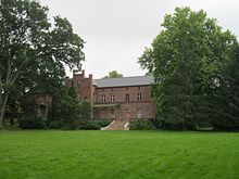
- Manor house (castle) with farm yard and park, built from 1856 to 1915
- Pigeon tower as a remnant of a medieval defense tower
- Fenn (high moor) in a depression in the middle of Wittenmoor, a nature reserve that is accessible via a stick dam
traffic
Wittenmoor is located on Landstrasse 30 from the neighboring district of Vinzelberg (connection to the B 188 ) to Lüderitz (connection to the B 189 ). Regular buses and on-call buses run by Regionalverkehr Westsachsen (RVW) under the brand name stendalbus .
The nearest train station is in the neighboring district of Vinzelberg (main line Hanover – Stendal – Berlin ).
Personalities
- Udo Gebhard Ferdinand von Alvensleben (1814–1879), Erbtruchsess, member of the Prussian manor house, acquired the Wittenmoor estate in 1841
- Count Albrecht von Alvensleben-Schönborn (1848–1928), Erbtruchsess, member of the Prussian manor house, was born in Wittenmoor
- Ludolf Udo von Alvensleben (1852–1923), owner of the Wittenmoor estate, district deputy, member of the Prussian manor house
- Udo von Alvensleben (1897–1962), owner of the Wittenmoor estate, art historian
- Ludolf Jacob von Alvensleben (1899–1953), SS standard leader as well as SS and police leader in Italy
- Wichard von Alvensleben (1902–1982), forester, officer, born in Wittenmoor
- Busso von Alvensleben (* 1949), diplomat
Web links
- Gut Wittenmoor on the website of the von Alvensleben family
- Material on Rittergut Wittenmoor (PDF; 259 kB) in the Duncker collection of the Central and State Library Berlin
Individual evidence
- ^ JAF Hermes, MJ Weigelt: Historical-geographical-statistical-topographical manual from the administrative districts of Magdeburg . Topographical part. Verlag Heinrichshofen, 1842, Volume 2, p. 306, Textarchiv - Internet Archive
- ↑ Administrative region of Magdeburg (Ed.): Official Gazette of the Government of Magdeburg . 1928, ZDB -ID 3766-7 , p. 209 .
- ^ Official Journal of the District , No. 20/2009. (PDF; 1.38 MB) pp. 283–284


