Island (stendal)
|
island
City of Stendal
Coordinates: 52 ° 33 ′ 42 " N , 11 ° 45 ′ 17" E
|
||
|---|---|---|
| Height : | 36 m above sea level NHN | |
| Area : | 25.16 km² | |
| Residents : | 729 (Dec. 31, 2009) | |
| Population density : | 29 inhabitants / km² | |
| Incorporation : | September 1, 2010 | |
| Postal code : | 39576 | |
| Area code : | 039329 | |
|
Location of Insel in Saxony-Anhalt |
||
|
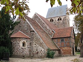
Kirche zu Insel (October 2018)
|
||
Insel is a district of the district town of Stendal in the Stendal district in Saxony-Anhalt (Germany).
geography
The Altmark town Insel is about 10 km from Stendal. The terrain slopes down from the Tangermünder-Buchholzer ridge towards the north to the Uchteniederung . The village and former municipality also include the districts of Döbbelin (137 inhabitants) and Tornau (122 inhabitants), which are located northeast of the island.
history
The island was first mentioned in a document in 1238 as insula slavica . The Latin term island can be translated as “ Werder ”. Already in 1282 the place Insel was divided into two villages (East and West Island).
Until 1813 there was an independent parish West Island. After the death of the then preacher Garn, it was united with the parish of Nahrstedt. The village of Mispelwerder was west of Insel. In 1680 Christian von Itzenplitz auf Jerchel was enfeoffed with the desert Feldmark Mispelwerder. At the beginning of the 19th century, remains of the walls of the church were reported.
On October 1, 1921 was Gutsbezirk West Island dissolved and incorporated into the rural community of West Island. The municipality Insel was created on April 1, 1935 through the merger of the rural municipalities East Island and West Island.
Until 1945 there was a manor of the von Cramm family in Insel . It belonged to the entire property of the neighboring Nahrstedt manor . The Inseler Rittergut farmed around 398 acres, so that it was actually not allowed to be expropriated by the “ land reform ”. The rulers at the time achieved the expropriation through a trick (the roads that led to the family's field mark were also measured). The von Cramm family then left Insel.
The small street village Döbbelin was first mentioned in 1160. There is evidence that the von Bismarck family had owned part of the village since 1344. The municipality of Döbbelin was incorporated into the municipality of Insel on July 1, 1973.
Tornau, also a typical street village, was first mentioned in a document in 1238 under the name tornow . The name of the place can be derived from Slavonic and can be translated as "Dornbusch". The municipality of Tornau was incorporated into the municipality of Insel on July 1, 1973.
After the dissolution of the Stendal-Uchtetal administrative community on January 1, 2010 and until it was incorporated on September 1, 2010, it was initially co-administered by Stendal.
The community hit the headlines in 2011 and 2012 when it became known that two released sex offenders had settled there. The citizens, also led by the local mayor Alexander von Bismarck, who publicly announced the name and place of residence of the two, started demonstrations from then on, which were later joined by right-wing extremists who were tolerated. In June 2012, Prime Minister Reiner Haseloff and around 70 members of the state parliament from all parliamentary groups demonstrated in the town for human dignity. In October 2012 the mayor and the entire local council resigned.
Attractions
- Local museum in island
- Tornau post mill - technical monument, reconstructed in 1985
- Inseler Feldsteinkirche from the 12th century
- Döbbelin manor from 1736
- Döbbelin village church and Tornau village church
traffic
The federal highway 188 leads through the local area .
Regular buses and on-call buses run by Regionalverkehr Westsachsen (RVW) under the brand name stendalbus . The nearest train station is in the neighboring town of Möringen on the Lehrter Bahn, around three kilometers away .
Personalities
- Luise Mewis (1864–1947), poet, died in Insel
Individual evidence
- ^ Peter Wilhelm Behrends: Count Siegfried von Osterburg and Altenhausen resigned many villages and properties in the Altmark in 1238 . Annual reports of the Altmark Association for Patriotic History. 4th Annual Report, 1841, p. 53 ( altmark-geschichte.de [PDF]).
- ^ A b August Wilhelm Pohlmann, August Stoepel: History of the City of Tangermünde. from the founding of the same until the current year 1829 . Franzen and Große, Stendal 1829, p. 365; accessed on April 16, 2017.
- ↑ Administrative region of Magdeburg (Ed.): Official Gazette of the Government of Magdeburg . 1921, ZDB -ID 3766-7 , p. 252 .
- ↑ Administrative region of Magdeburg (Ed.): Official Gazette of the Government of Magdeburg . 1935, ZDB -ID 3766-7 , p. 59 u. 139 .
- ↑ Description at geocaching.com, accessed on January 23, 2020
- ↑ Federal Statistical Office (Ed.): Municipalities 1994 and their changes since 01.01.1948 in the new federal states . Metzler-Poeschel, Stuttgart 1995, ISBN 3-8246-0321-7 , pp. 345 .
- ↑ Federal Statistical Office (Ed.): Municipalities 1994 and their changes since 01.01.1948 in the new federal states . Metzler-Poeschel, Stuttgart 1995, ISBN 3-8246-0321-7 , pp. 346 .
- ↑ StBA: Area changes from January 01 to December 31, 2010 .
- ↑ Hendrik Kranert-Rydzy: Sex offenders give in to pressure. In: Mitteldeutsche Zeitung , October 5, 2011, accessed on October 6, 2011
- ↑ Hendrik Kranert-Rydzy: The drama of island. In: Mitteldeutsche Zeitung , November 4, 2011; Retrieved November 5, 2011.
- ↑ Anne Hähnig: Island of the wretched . In: Die Zeit , No. 25/2012.
- ^ Island: Local council resigns completely . In: Volksstimme , October 15, 2012; Retrieved April 1, 2015


