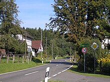
Herchener height
The Herchener Höhe is a collection of small villages in the municipality of Windeck . The height is north of Herchen between Ottersbach and Kaltbachtal in Nutscheid . It is crossed by the state road 312 . The German Unity hiking trail leads over the Herchener Höhe.
The localities include
- Neuenhof
- Ring spots
- (Nieder- and Ober-) Rieferath
- Lüttershausen
- the chapel village Gutmannseichen and
- Altenherfen
Altenherfen is the cultural center of the Herchener Höhe with its St. Martin branch church, which was inaugurated in 1972, and the sports field of the football club Höhe 1921 eV .
The secluded, former service buildings forester's house and village school Höhe now serve as residential buildings.
Population numbers
1810
| District | Catholics | Lutheran | Residents |
| Altenherfen | 38 | no | 38 |
| Gutmannseichen | 55 | no | 55 |
| Lüttershausen | 58 | 6th | 64 |
| Niederrieferath | 34 | 34 | 68 |
| Oberrieferath | 39 | 19th | 58 |
| Ring spots | 34 | no | 34 |
1885
| District | Houses | Residents |
|---|---|---|
| Altenherfen | 13 | 51 |
| Gutmannseichen | 21st | 91 |
| Lüttershausen | 20th | 106 |
| Neuenhof | 6th | 22nd |
| Niederrieferath | 14th | 55 |
| Oberrieferath | 18th | 60 |
| Ring spots | 10 | 27 |
Current population figures
- Altenherfen - 25
- Gutmannseichen - 89
- Lüttershausen - 80
- Neuenhof - 47
- Rieferath - 152
- Ring sites - 32
(As of December 31, 2011)
history
On October 19, 1795, the peasants of the Herchener Höhe attacked a group of advancing French revolutionary soldiers. Here Johann Peter Stockhausen from Gutmannseichen, Franz Sieberz from Altenherfen, Johann Peter Lenz from Niederrieferath and Johannes Engelbert Sainsch from Lüttershausen perished.
Individual evidence
- ^ Community encyclopedia for the Kingdom of Prussia from 1885
- ↑ Population figures
Coordinates: 50 ° 49 ' N , 7 ° 29' E


