Interstate 805
| Basic data | |||||||||||||||||||||||||||||||||||||||||||||||||||||||||||||||||||||||||||||||||||||||||||||||||||||||||||||||||||
|---|---|---|---|---|---|---|---|---|---|---|---|---|---|---|---|---|---|---|---|---|---|---|---|---|---|---|---|---|---|---|---|---|---|---|---|---|---|---|---|---|---|---|---|---|---|---|---|---|---|---|---|---|---|---|---|---|---|---|---|---|---|---|---|---|---|---|---|---|---|---|---|---|---|---|---|---|---|---|---|---|---|---|---|---|---|---|---|---|---|---|---|---|---|---|---|---|---|---|---|---|---|---|---|---|---|---|---|---|---|---|---|---|---|---|---|
| Length: | 29 mi / 46 km | ||||||||||||||||||||||||||||||||||||||||||||||||||||||||||||||||||||||||||||||||||||||||||||||||||||||||||||||||||
| State: |
California |
||||||||||||||||||||||||||||||||||||||||||||||||||||||||||||||||||||||||||||||||||||||||||||||||||||||||||||||||||
| map | |||||||||||||||||||||||||||||||||||||||||||||||||||||||||||||||||||||||||||||||||||||||||||||||||||||||||||||||||||

|
|||||||||||||||||||||||||||||||||||||||||||||||||||||||||||||||||||||||||||||||||||||||||||||||||||||||||||||||||||
|
course
|
|||||||||||||||||||||||||||||||||||||||||||||||||||||||||||||||||||||||||||||||||||||||||||||||||||||||||||||||||||
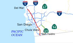
The Interstate 805 (abbreviated I-805 ) is an interstate highway in the United States and runs at San Diego in California parallel to Interstate 5 .
course
The I-805, also known as the Jacob Dekema Freeway or simply the 805, serves as a bypass of I-5 in the metropolitan area of San Diego. In the south it starts on I-5 just after the border with Mexico and then leads through the cities of Chula Vista and National City as well as Mira Mesa, a district of San Diego. The interstate consists of eight to ten lanes up to Chula Vista. In the further course it crosses, among other things, some industrial areas of San Diego in the Sorrento Valley until it meets Interstate 5 again near the Carmel Valley .
The I-805 crosses the Misson Valley with a high bridge.
The northern triangle with Interstate 5 was expanded and opened to traffic in early April 2007. At its widest point, the interstate includes 22 lanes in this area, including the HOV lanes. Many companies have settled along I-805. It is one of two north-south interstates in California that almost lead to the Mexican border.
history
First plans to build the road were published in 1959. It was approved as an interstate and later designated a state route. Between 1970 and 1975 the road was built as an interstate.
Web links
- California @ AARoads route description with photos
- California Highways (English)


