Interstate 105 (California)
| Basic data | ||||||||||||||||||||||||||||||||||||||||||||||||||||||||||||||||
|---|---|---|---|---|---|---|---|---|---|---|---|---|---|---|---|---|---|---|---|---|---|---|---|---|---|---|---|---|---|---|---|---|---|---|---|---|---|---|---|---|---|---|---|---|---|---|---|---|---|---|---|---|---|---|---|---|---|---|---|---|---|---|---|---|
| Length: | 18.82 mi / 30.29 km | |||||||||||||||||||||||||||||||||||||||||||||||||||||||||||||||
| State: |
California |
|||||||||||||||||||||||||||||||||||||||||||||||||||||||||||||||
| map | ||||||||||||||||||||||||||||||||||||||||||||||||||||||||||||||||

|
||||||||||||||||||||||||||||||||||||||||||||||||||||||||||||||||
|
course
|
||||||||||||||||||||||||||||||||||||||||||||||||||||||||||||||||
Interstate 105 (abbreviation I-105 ), also Glenn Anderson Freeway , is an interstate highway in Los Angeles County in the US state of California .
course
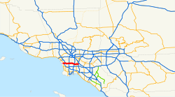
Interstate 105 begins on Sepulveda Boulevard ( California State Route 1 ) in El Segundo . From there it leads east over the Los Angeles River and San Gabriel River . The interstate ends in Norwalk on Interstate 605 . It crosses in Inglewood with the Interstate 405 and in Lynwood with Interstate 710 . The intersection with Interstate 110 is named Judge Harry Pregerson Interchange . The tracks of the Green Line , a light rail line of the Los Angeles Metro, run in the median of the freeway .
Web links
Commons : Interstate 105 - collection of images, videos and audio files
- California @ AA Roads route description with photos
- Los Angeles Freeways (English)

