
Hartkirchen
|
Hartkirchen
|
||
|---|---|---|
| coat of arms | Austria map | |
 |
|
|
| Basic data | ||
| Country: | Austria | |
| State : | Upper Austria | |
| Political District : | Eferding | |
| License plate : | EF | |
| Surface: | 39.04 km² | |
| Coordinates : | 48 ° 22 ' N , 14 ° 0' E | |
| Height : | 273 m above sea level A. | |
| Residents : | 4,073 (January 1, 2020) | |
| Population density : | 104 inhabitants per km² | |
| Postal code : | 4081 | |
| Area code : | 07273 | |
| Community code : | 4 05 06 | |
| NUTS region | AT312 | |
| Address of the municipal administration: |
Kirchenplatz 1 4081 Hartkirchen |
|
| Website: | ||
| politics | ||
| Mayor : | Wolfram Moshammer ( SPÖ ) | |
|
Municipal Council : (Election year: 2015) (25 members) |
||
| Location of Hartkirchen in the Eferding district | ||
  |
||
| Source: Municipal data from Statistics Austria | ||

Hartkirchen is a municipality in Upper Austria with 4073 inhabitants (as of January 1, 2020) in the Eferding district in the Hausruckviertel . The community is located in the judicial district of Eferding .
geography
Hartkirchen is located at an altitude of 273 m in the northern Hausruckviertel . The extension is from north to south 7.3 km, from west to east 9.6 km. The total area is 39 km². 27.2% of the area is forested, 59.7% of the area is used for agriculture.
In the north, the municipality lies at the foothills of the Sauwald forest , which is remarkable in that it is geologically the continuation of the “Bohemian mass” beyond the Mühlviertel side of the Danube. In the southeast, the municipality opens up to the Eferdinger Basin , whose extensive agricultural area gives the municipality its agrarian character.
Community structure
The municipality includes the following 37 localities (population in brackets as of January 1, 2020):
- Deinham (128)
- Village (34)
- Gfehret (43)
- Gstaltenhof (8)
- Hachlham (166)
- Hacking (56)
- Hainbach (97)
- Haizing (252)
- Hartkirchen (1092)
- Hard whether hacking (17)
- Hart ob Haizing (29)
- Hilkering (182)
- Hinteraigen (22)
- Hinterberg (4)
- Hörmannsedt (42)
- Karling (457)
- Waiting (156)
- Knieparz under the Leithen (27)
- Coupling (89)
- Lacquers (44)
- Mussbach (102)
- Oed in Bergen (53)
- Paching (30)
- Pfaffing (40)
- Poxham (124)
- Pupping (3)
- Rathen (54)
- Reith (33)
- Rienberg (63)
- Schaumberg (159)
- Schoenleiten (32)
- Senghuebl (78)
- Stone wall (86)
- Front wood (179)
- Wolfsfurth (9)
- Würting (50)
- Zagl (33)
The community consists of the cadastral communities Hartkirchen, Oed in Bergen and Schaumberg. Counting areas are Hartkirchen-Zentralgebiet, Hartkirchen-Süd, Hartkirchen-Nord .
Neighboring communities
Neighboring communities in Hartkirchen are:
|
Danube
|
Kirchberg ob der Donau ( District Rohrbach )
Danube |
Danube * |
.svg)
|
Donau Feldkirchen an der Donau ( District Urfahr-Umg. )
|
|
| Stroheim |
Danube
|
- *behind Aschach, which stretches narrowly on the banks of the Danube, lies, somewhere bordering Hartkirchen, St. Martin im Mühlkreis , district Rohrbach
history
Hartkirchen was first mentioned in a document in 898. Originally located in the eastern part of the Duchy of Bavaria, the place belonged to the Duchy of Austria since the 12th century.
The rule of the Counts of Schaunberg represents the defining component of the High Middle Ages. Since 1490 it has been part of the Principality of Austria above the Enns .
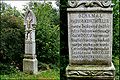
During the Napoleonic Wars , the place was occupied several times. The French cross (monument to Jakob Kemetmüller) in the village of Poxham reminds us that the French troops passing through in 1809 murdered the farmer Kemetmüller.
Since 1918 the place belongs to the federal state of Upper Austria .
During the First World War , a prisoner of war camp covered an area of 130 hectares. It bordered on the villages of Hartkirchen, Aschach and Karling . During the Second World War , the area of the camp cemetery was used as a mass grave by the nearby Pupping prisoner of war camp (last officially referred to as “ Stalag 398 Pupping”).
The war memorial in Deinham commemorates 6,025 soldiers, mostly Serbs, from the First World War and 1,027 Russians from the Second World War.
Today the community is largely agricultural, which also has to do with the geographical location in the agricultural area "Eferdinger Becken". The rural way of life is still a tradition in Hartkirchen.
Population development
In 1991 the community had 4,011 inhabitants according to the census, in 2001 it had 4,190 inhabitants.

politics
The municipal council consists of 25 members and, since the municipal council election in 2015, has consisted of mandataries from the following parties: ÖVP 9, SPÖ 7, FPÖ 6, GRÜNE 3.
- mayor
- 1924–1929 Josef Hager
- 1929–1942 Josef Hofer
- 1942–1945 Matthias Gruber
- 1945–1946 Karl Mallinger
- 1946–1973 Johann Dirnberger
- 1973–1990 Gottfried Augdoppler
- 1990–2002 Leopold Hofer
- 2002–2015 Wolfgang Schöppl (ÖVP)
- since 2015 Wolfram Moshammer (SPÖ)
coat of arms
Description of the municipal coat of arms:
- Shared ; above in a silver red beam , a blue below in grain silver flower , switched from a blue, issued rafters .
The community colors are blue and white .
The rafters and the red-white-red bars go back to the Schaunberg family coat of arms , whose Schaunberg Castle, built in the 12th century, is located in the municipality. The cornflower symbolizes the predominantly agricultural character of the community.
Community partnerships

- Halstenbek in Schleswig-Holstein since 1984
- Lübz in Mecklenburg-Western Pomerania since May 26, 1995
traffic
- Railway: The railway line of the Aschacher Bahn runs through the municipality . The center of the village is accessible via the Aschach ad Donau train station. There is a train stop in the municipality in Karling. The rail freight traffic on the Aschacherbahn is significant, the passenger traffic is currently limited to one pair of trains per working day (as of 2007) and special traffic to the vegetable fair in Pupping .
- Bus: Hartkirchen is on the bus routes:
- Linz - Eferding - Passau / Haibach / St.Agatha / St.Aegidi (line no. 670/671 / S209)
- Aschach - Eferding - Wallern - Wels (660)
- Bad Mühllacken - Eferding - Kirchberg - Pasching - Leonding Meixnerkreuzung (688)
education
- Hartkirchen elementary school
- New Hartkirchen Middle School (currently in Aschach an der Donau)
- State Music School Hartkirchen
The Hilkering elementary school, which has existed since 1940, was closed in 2016. The building is now used by the Hartkirchen kindergarten and houses two crawling groups and one kindergarten group.
Culture and sights
- Schaunberg castle ruins : Today's Schaunberg ruins were the largest castle complex in Upper Austria with an area of 17,500 m². In the 32 m high keep, steel stairs lead to a viewing platform.
- Parish church Hartkirchen : The baroque parish church was built in the years 1717–1719 in the same dimensions as the previous Gothic building. The baroque extension of the church tower was carried out in 1748 by the Linz architect Johann Matthias Krinner. The presbytery and the main nave were decorated with frescoes by Wolfgang Andreas Heindl in 1751/52 .
- Hilkering pilgrimage church : the church is consecrated to St. John the Baptist and is built on the steep north terrace of the Aschach. The church is single-nave and the main parts of the church are late Gothic. Today's church was built shortly after 1514 on a Gothic floor plan and was converted to Baroque style in 1750 on the occasion of Mathias Dollicher's expansion. The place Hilkering comes from the first wave of Bavarian settlement at the beginning of the 6th century. According to legend, a hermit named Hilarius cleared the area a long time ago and built a wooden chapel.
- French Cross - Monument to Jakob Kemetmüller from the Napoleonic Wars

Pilgrimage Church Hilkering
French cross


Personalities
- Richard Billinger (1890–1965), writer and poet, buried in Hartkirchen
- Ferdinand Umenberger (1901–1992), member of the National Council, local council in Hartkirchen
Web links
- Website of the municipality (ooe.gv.at)
- Entry on Hartkirchen in the Austria Forum (in the AEIOU Austria Lexicon )
- 40506 - Hartkirchen. Community data, Statistics Austria .
- Map in the Digital Upper Austrian Room Information System ( DORIS )
- Further information about the municipality of Hartkirchen can be found on the geographic information system of the federal state of Upper Austria .
Individual evidence
- ↑ Statistics Austria: Population on January 1st, 2020 by locality (area status on January 1st, 2020) , ( CSV )
- ↑ Hubert Speckner: In the power of the enemy: POW camp in the "Ostmark" 1939 to 1945. R. Oldenbourg, Munich / Vienna 2003, ISBN 3-486-56713-6 , p. 258.
- ↑ Population development 1869 - 2019 (Hartkirchen community). Statistics Austria, accessed on October 18, 2019 .
- ^ Province of Upper Austria - Hartkirchen municipality. Retrieved October 15, 2019 .
- ↑ Hilkering elementary school closes 76 years after opening. Oberösterreichische Nachrichten , April 19, 2016, accessed on May 22, 2017 .

Cadastral communities: Hartkirchen | Oed in mountains | Schaumberg
Localities: Deinham | Village | Gfehret | Gstaltenhof | Hachlham | Hacking | Hainbach | Haizing | Hard whether hacking | Hart ob Haizing | Hartkirchen | Hilkering | Hinteraigen | Hinterberg | Hörmannsedt | Karling | Waiting | Knieparz under the Leithen | Coupling | Lacquers | Mußbach | Oed in mountains | Paching | Pfaffing | Poxham | Pupping | Rathen | Reith | Rienberg | Schaumberg | Schönleiten | Senghübl | Stone wall | Lumber | Wolfsfurth | Würting | Zagl
Villages:
Deinham •
Hachlham •
Hacking •
Hainbach •
Haizing •
Hartkirchen •
Hilkering •
Karling •
Kellnering •
Pfaffing •
Poxham •
Rathen •
Rienberg •
Vornholz |
Weiler:
Gstaltenhof •
Gschwendt •
Hart ob Hacking •
Wolfsfurth |
Rotten:
Gfehret •
Hart ob Haizing •
Hinteraigen •
Hörmannsedt •
Koppl •
Lacken •
Oed in Bergen •
Paching •
Reith •
Schaumberg above Leithen •
Schaumberg under the Leithen •
Schönleiten •
Senghübl •
Steinwand |
Settlement:
Brandstätter See settlement |
Scattered houses:
Village •
Knieparz under the Leithen •
Mußbach •
Würting •
Zagl
Other locations:
Hinterberg •
Pupping •
Schaumberg ruins
Counting district: Hartkirchen-Zentralgebiet | Hartkirchen-South | Hartkirchen-North