
Ratshausen
| coat of arms | Germany map | |
|---|---|---|

|
Coordinates: 48 ° 12 ' N , 8 ° 48' E |
|
| Basic data | ||
| State : | Baden-Württemberg | |
| Administrative region : | Tübingen | |
| County : | Zollernalb district | |
| Height : | 675 m above sea level NHN | |
| Area : | 5.77 km 2 | |
| Residents: | 762 (Dec. 31, 2018) | |
| Population density : | 132 inhabitants per km 2 | |
| Postal code : | 72365 | |
| Area code : | 07427 | |
| License plate : | BL, HCH | |
| Community key : | 08 4 17 052 | |
| LOCODE : | DE RTU | |
| Address of the municipal administration: |
Schlosshof 4 72365 Ratshausen |
|
| Website : | ||
| Mayor : | Heiko Lebherz | |
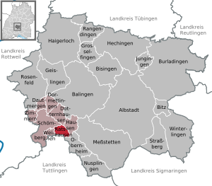
| Location of the municipality of Ratshausen in the Zollernalb district | ||
  |
||

.jpg)
Wolfratshausen is a municipality in the Zollernalbkreis in Baden-Wuerttemberg ( Germany ). Apart from the village of the same name, no other localities belong to the municipality of Ratshausen .
geography

Geographical location
Ratshausen is located on the western edge of the Swabian Alb southwest of the Plettenberg . The Ortenberg is located south of Ratshausen . Ratshausen is crossed by the small river Schischem . The community is located in the middle of the local recreation area Oberes Schischemtal .
Neighboring communities
The neighboring municipalities clockwise (starting in the north):
Historical geography
The desert areas Kernhausen and Reuthalde are located in the municipality . The Reuthalde farm was built at the beginning of the 19th century and was demolished in 1862.
history
Ratshausen
The oldest known name comes from the year 1371 and is Raulshausen (personal name Radult or Radulf). However, Ratshausen (and also Kernhausen) is a settlement from the earlier expansion period, at the latest from the 8th century.
In the early Middle Ages , Ratshausen was part of the County of Scherra , over which the County of Hohenberg later gained sovereignty. Together with the County of Hohenberg, Ratshausen came to the Habsburgs ( Swabian Austria ) in 1381 . Ratshausen was then a direct part of the Oberhohenberg rule (Obervogteiamt Fridingen, after 1688 Obervogteiamt Spaichingen). In the second half of the 18th century, the district of the County of Hohenberg also functioned under the names Oberamt Rottenburg and Oberamt Hohenberg.
In the early modern period , Ratshausen (and Kernhausen) was mostly part of the parish of Schömberg , in 1788 Ratshausen became part of the newly created parish of Kernhausen.
As part of the process of dissolving the Old Kingdom between 1803 and 1806, Ratshausen came to Württemberg in 1805 ( Oberamt Spaichingen ). In 1938 Ratshausen became part of the Balingen district . After its dissolution, Ratshausen has been part of the Zollernalb district since January 1, 1973.
One of the historical features of the village of Ratshausen is the strikingly frequent occurrence of the name Dannecker, made famous by the sculptor Johann Heinrich von Dannecker , who was born in Waldenbuch near Stuttgart . Ratshausen is significant as the ancestral home of the Dannecker family. "The common progenitor of the Dannecker clan is the farmer Hans Dannecker, who lived around 1580 [...] in the small village of Ratshausen."
Kernhausen
Up until 1400 there was another small village called Kernhausen on the Ratshausen mark. The place Kernhausen was first mentioned in 1258 as Kerenhusen . In the first half of the 13th century, the Lords of Lupfen founded a nunnery here, which was moved to Offenhausen around 1258/62 and was named Gnadenzell there.
The possessions in Kernhausen initially remained in the possession of the monastery, in 1310 the farm was sold to a knight of low nobility, who subsequently called himself Kernhauser . Around 1400 there was only a church, chaplaincy and sacristan's house .
The Afra church of Kernhausen served the residents of Ratshausen as a village church until around 1810; a new church was only built in Ratshausen between 1816 and 1823 and the church was demolished after 1816.
politics
Municipal council
The council in Ratshausen has eight members. It consists of the voluntary councilors and the mayor as chairman. The mayor is entitled to vote in the municipal council. In the local elections on May 26, 2019, the local council was elected by majority vote. Majority voting takes place if no or only one nomination has been submitted. The applicants with the highest number of votes are then elected. The turnout was 69.8% (2014: 63.5%).
mayor
In July 2010, the social host Heiko Lebherz was elected the new mayor with 56.6 percent of the vote, and was re-elected in 2018. Predecessor Michael Maier (CDU) moved to Winterlingen after 19 years.
traffic
The Public transport is by the Verkehrsverbund Neckar-Alb-Donau guaranteed (NALDO).
sons and daughters of the town
- Anton von Dannecker (1816–1881), Catholic theologian, cathedral chapter and papal house prelate, 1868–1870 member of the state parliament as a member of the cathedral chapter.
Web links
Individual evidence
- ↑ State Statistical Office Baden-Württemberg - Population by nationality and gender on December 31, 2018 (CSV file) ( help on this ).
- ^ The state of Baden-Württemberg. Official description by district and municipality. Volume VII: Tübingen administrative region. Kohlhammer, Stuttgart 1978, ISBN 3-17-004807-4 . Pp. 247-248
- ↑ https://www.leo-bw.de/web/guest/detail-gis/-/Detail/details/ORT/labw_ortslexikon/16485/Ratshausen+-+Altgemeinde%7ETeilort
- ↑ https://www.leo-bw.de/web/guest/detail-gis/-/Detail/details/ORT/labw_ortslexikon/16485/Ratshausen+-+Altgemeinde%7ETeilort
- ↑ https://www.leo-bw.de/web/guest/detail-gis/-/Detail/details/ORT/labw_ortslexikon/16485/Ratshausen+-+Altgemeinde%7ETeilort
- ↑ https://www.leo-bw.de/web/guest/detail-gis/-/Detail/details/ORT/labw_ortslexikon/16485/Ratshausen+-+Altgemeinde%7ETeilort
- ↑ https://www.leo-bw.de/web/guest/detail-gis/-/Detail/details/ORT/labw_ortslexikon/16485/Ratshausen+-+Altgemeinde%7ETeilort
- ↑ https://www.leo-bw.de/web/guest/detail-gis/-/Detail/details/ORT/labw_ortslexikon/16485/Ratshausen+-+Altgemeinde%7ETeilort
- ↑ Sheets for Württemberg Family Studies, Book 99 <Bd. 9, issue 3>, May 1942, p. 43.
- ↑ Preliminary results of the 2019 municipal council elections at the State Statistical Office

Albstadt | Balingen | Bisingen | Bitz | Burladingen | Dautmergen | Dormettingen | Dotternhausen | Geislingen | Grosselfingen | Haigerloch | Hausen am Tann | Hechingen | Jungingen | Meßstetten | Nusplingen | Obernheim | Rangendingen | Ratshausen | Rosenfeld | Schömberg | Straßberg | While under the gutters | Winterlingen | Rooms under the castle