La Désirade
|
La Désirade Dézirad or Déziwad |
|
|---|---|

|
|
| region | Guadeloupe |
| Department | Guadeloupe |
| Arrondissement | Pointe-à-Pitre |
| Canton | Saint-François |
| Community association | La Riviéra du Levant |
| Coordinates | 16 ° 18 ′ N , 61 ° 5 ′ W |
| height | 0-276 m |
| surface | 23.12 km 2 |
| Residents | 1,448 (January 1, 2017) |
| Population density | 63 inhabitants / km 2 |
| Post Code | 97127 |
| INSEE code | 97110 |
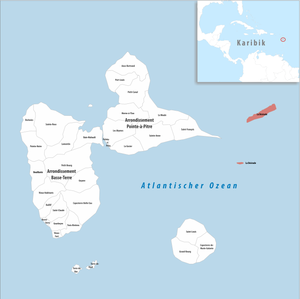
La Désirade ( Guadeloupe Creole : Dézirad or Déziwad ) is an island and a municipality with 1,448 inhabitants (as of January 1, 2017) in the French overseas department of Guadeloupe .
Christopher Columbus discovered the island of La Désirade after a long and hard crossing on November 3rd, 1493. For this reason he also called it Desiderada: the one longed for! La Désirade is 11 km long and 2 km wide and covers an area of 21.12 km². La Désirade protrudes up to 276 m from the sea. La Désirade was first verifiably mentioned in 1728. During this time, a leprosy station for the French Antilles was established here , which existed until 1954.
The uninhabited archipelago of Petite Terre, 12 kilometers to the south, also belongs to the municipality .
The localities on La Désirade
La Désirade has only one street that connects the main town of Beauséjour with the districts of Les Galets, Le Souffleur and Baie-Mahault. The port and airport of La Désirade are located in the southwest of the island, in Beauséjour. The place is alternatively called Grand Anse or Le-Bourg. In the small districts of Baie-Mahault, Le Galets and Le Souffleur, there are only smaller settlements with very few inhabitants.
- Beauséjour (main town, southwest)
- Baie-Mahault (northeast)
- Les Galets (extreme southwest)
- Le Souffleur (central south coast)
Web links
Individual evidence
- ↑ Désirade, La . In: Meyers Großes Konversations-Lexikon . 6th edition. Volume 4, Bibliographisches Institut, Leipzig / Vienna 1906, p. 670 .