
Le Moule
|
Le Moule Moul |
|
|---|---|

|

|
| region | Guadeloupe |
| Department | Guadeloupe |
| Arrondissement | Pointe-à-Pitre |
| Canton | Le Moule |
| Community association | North Grande-Terre |
| Coordinates | 16 ° 20 ′ N , 61 ° 21 ′ W |
| height | 0-110 m |
| surface | 82.84 km 2 |
| Residents | 22,150 (January 1, 2017) |
| Population density | 267 inhabitants / km 2 |
| Post Code | 97160 |
| INSEE code | 97117 |
| Website | http://www.lemoule.fr/ |
Le Moule ( Guadeloupe Creole : Moul ) is a municipality with 22,150 inhabitants (as of January 1, 2017) in the French overseas department of Guadeloupe . The inhabitants call themselves Mouliens . The settlement was established during the 18th century and is located in the center of the eastern shore of the Grande-Terre island . Therefore the community borders on the Atlantic Ocean .
| Population development Le Moule | |||||||
|---|---|---|---|---|---|---|---|
| year | 1961 | 1967 | 1974 | 1982 | 1990 | 1999 | 2014 |
| Residents | 15,012 | 16,111 | 16,705 | 15,224 | 18,054 | 20,827 | 22.101 |
Infrastructure
Le Moule has a boat harbor that is used by many windsurfers and kayakers . Numerous shops from various industries have settled in Le Moule.
Attractions
- Church Saint Jean-Baptiste , Monument historique
- La maison coloniale de Zévallos , home of a former sugar plantation, Monument historique
- St-Guillaume Mill
- Edgar-Clerc Archaeological Museum
- Damoiseau rum distillery
Personalities
- Joseph Arame (* 1948), sprinter

Church Saint Jean-Baptiste

Habitation Zévallos

Le Moule town hall
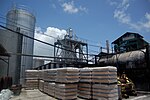
Damoiseau distillery


Web links
Commons : Le Moule - collection of images, videos and audio files