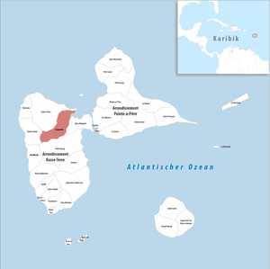
Lamentin
|
Lamentin Manten or Lamanten |
|
|---|---|

|
|
| region | Guadeloupe |
| Department | Guadeloupe |
| Arrondissement | Basse-Terre |
| Canton | Lamentin |
| Community association | North Basse-Terre |
| Coordinates | 16 ° 16 ′ N , 61 ° 38 ′ W |
| height | 0-740 m |
| surface | 65.60 km 2 |
| Residents | 16,573 (January 1, 2017) |
| Population density | 253 inhabitants / km 2 |
| Post Code | 97129 |
| INSEE code | 97115 |
| Website | http://villelamentin971.fr/ |
 Habitation Routa, an early 20th century distillery |
|
Lamentin ( Guadeloupe Creole : Manten or Lamanten ) is a municipality with 16,573 inhabitants (as of January 1, 2017) in the French overseas department of Guadeloupe .
geography
Lamentin is located in the northern part of the island of Basse-Terre . The castle, which was once built to protect the settlement, stands on the bay called Baie du Grand Cul-de-Sac marin . The three islands that make up the municipality are called Christophe , Fajou and Caret .
history
A first documentary mention comes from the year 1720. Depending on the time period, the place was also called du Lamentin or Lamantin .
Plantation economy found its way into the 18th century. They started growing coffee , cocoa and other products.
In 1920 a tropical cyclone affected the village. The church, the Palace of Justice and the administration building were reconstructed by the architect Ali Tur as a result of the destruction .
| Population development | ||||||||
|---|---|---|---|---|---|---|---|---|
| year | 1961 | 1967 | 1974 | 1982 | 1990 | 1999 | 2006 | 2012 |
| Residents | 8,840 | 8,919 | 9,643 | 9,885 | 11,334 | 13,434 | 15,738 | 15,624 |