Deshaies
|
Deshaies Déhé |
|
|---|---|

|
|
| region | Guadeloupe |
| Department | Guadeloupe |
| Arrondissement | Basse-Terre |
| Canton | Sainte-Rose-1 |
| Community association | North Basse-Terre |
| Coordinates | 16 ° 18 ′ N , 61 ° 48 ′ W |
| height | 0-758 m |
| surface | 31.10 km 2 |
| Residents | 4,081 (January 1, 2017) |
| Population density | 131 inhabitants / km 2 |
| Post Code | 97126 |
| INSEE code | 97111 |
| Website | www.villededeshaies.fr |
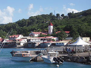
 View of the town of Deshaies |
|
Deshaies ( Guadeloupe Creole : Déhé ) is a municipality with 4081 inhabitants (as of January 1, 2017) in the French overseas department of Guadeloupe .
geography
Deshaies is located in the northwest of the island of Basse-Terre on the coast of the Caribbean Sea . Neighboring communities are Pointe-Noire in the south and Sainte-Rose in the east .
history
After the occupation of Guadeloupe by French colonists began in 1635, one can speak of the current place from 1730, which was initially known under the name of Des Hayes .
On 22 June 1962, a crashed Boeing 707 of Air France about 40 kilometers from the planned landing at the airport Pointe-a-Pitre from not entirely clear reasons about the municipality of Deshaies from. All 113 occupants of the aircraft, passengers and crew, were killed.
| Population development | ||||||||
|---|---|---|---|---|---|---|---|---|
| year | 1961 | 1967 | 1974 | 1982 | 1990 | 1999 | 2006 | 2012 |
| Residents | 3,271 | 3,305 | 3,519 | 3,485 | 3,476 | 4,039 | 4,287 | 4,271 |
Attractions
In Deshaies there is a botanical and an orchid garden . They are officially called Le jardin botanique de Deshaies and Le jardin des orchidées .
Trivia
- The crime series Death in Paradise has been filmed in Deshaies since 2011.
