
Le Gosier
|
Le Gosier Gozyé |
|
|---|---|

|

|
| region | Guadeloupe |
| Department | Guadeloupe |
| Arrondissement | Pointe-à-Pitre |
| Canton |
Le Gosier , Les Abymes-3 |
| Community association | La Riviéra du Levant |
| Coordinates | 16 ° 12 ′ N , 61 ° 30 ′ W |
| height | 0-125 m |
| surface | 45.20 km 2 |
| Residents | 26,783 (January 1, 2017) |
| Population density | 593 inhabitants / km 2 |
| Post Code | 97190 |
| INSEE code | 97113 |
| Website | www.villedugosier.fr |
Le Gosier ( Guadeloupe Creole : Gozyé ) is a municipality with 26,783 inhabitants (as of January 1, 2017) in the French overseas department of Guadeloupe . The locals call themselves les Gosiériens . The village is located on the island of Grande-Terre . In the 17th century the name Grand-gosier appeared . The pelicans were called "Gosieres" in colloquial language . Today tourism plays an important role there.
Attractions
- L'îlet du Gosier is a Caribbean island near Le Gosier that is one kilometer in diameter. The corals are a special feature there .
- The Aquarium de Guadeloupe is an oversized aquarium with 35 tanks that together hold around 200,000 liters of water.
- The Fort Fleur d'épée is a former fortress . It was built between 1750 and 1763 according to plans by the architect Sébastien Le Prestre de Vauban and was then used by the French military under the direction of Victor Hugues ( Monument historique ).

Fort Fleur d'épée
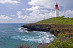
L'îlet du Gosier , lighthouse
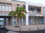
City Hall (Mairie) Le Gosier
.JPG)
.jpg)

Web links
Commons : Le Gosier - collection of images, videos and audio files