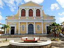
Pointe-à-Pitre
|
Pointe-à-Pitre Lapwent |
|
|---|---|

|

|
| region | Guadeloupe |
| Department | Guadeloupe |
| Arrondissement | Pointe-à-Pitre |
| Canton | Pointe-à-Pitre |
| Community association | Cap Excellence |
| Coordinates | 16 ° 14 ′ N , 61 ° 32 ′ W |
| height | 0-26 m |
| surface | 2.66 km 2 |
| Residents | 15,923 (January 1, 2017) |
| Population density | 5,986 inhabitants / km 2 |
| Post Code | 97110 |
| INSEE code | 97120 |
| Website | www.ville-pointeapitre.fr |
 Market in Pointe-à-Pitre |
|
Pointe-à-Pitre ( Guadeloupe Creole : Lapwent ) is a municipality with 15,923 inhabitants (as of January 1, 2017) and the largest city in the French overseas department of Guadeloupe . It is located in the west of the Grande-Terre island . It is the capital and seat of the sub-prefecture of the Arrondissement Pointe-à-Pitre .
Almost 100,000 people live in the metropolitan area around Pointe-à-Pitre, about a quarter of Guadeloupe's population. The Pointe-à-Pitre International Airport , which has daily flights from Paris, is named after the community, although he in the field of Common Les Abymes is.
In a ranking of cities according to their quality of life, Pointe-à-Pitre took 73rd place out of 231 cities worldwide in 2018.
| Pointe-à-Pitre Airport | ||||||||||||||||||||||||||||||||||||||||||||||||
|---|---|---|---|---|---|---|---|---|---|---|---|---|---|---|---|---|---|---|---|---|---|---|---|---|---|---|---|---|---|---|---|---|---|---|---|---|---|---|---|---|---|---|---|---|---|---|---|---|
| Climate diagram | ||||||||||||||||||||||||||||||||||||||||||||||||
| ||||||||||||||||||||||||||||||||||||||||||||||||
history
The city was founded in 1763 under the name Morne Renfermé ("enclosed hill") after Guadeloupe fell from England to France again through the Peace of Paris . In 1780 the city was destroyed by a major fire. After its reconstruction, around sixty years later the city already had around 20,000 inhabitants. At that time the sugar industry was the city's main trade. Sugar was processed in over fifty factories that existed in and around Pointe-à-Pitre and was mainly intended for export to France.
On February 8, 1843, there was a devastating earthquake that almost completely destroyed the city and killed around 6000 people.
| year | 1967 | 1974 | 1982 | 1990 | 1999 | 2009 |
|---|---|---|---|---|---|---|
| Residents | 29,522 | 23,889 | 25,310 | 26,029 | 20,931 | 17,017 |
Town twinning
Since 1973 there has been a twinning with the French city of Orly .
Personalities
- Roch-Ambroise Auguste Bébian (1789–1839), teacher and school director in France
- Roger Fanfant (1900–1966), jazz accordionist and violinist
- Claude Martial (1913–1991), jazz pianist, guitarist and banjo player
- Al Lirvat (1916-2007), trombonist, guitarist
- Jacques Cachemire (born 1947), basketball player
- Firmine Richard (born 1947), actress
- Joëlle Ursull (* 1960), singer
- Jacques Schwarz-Bart (* 1962), jazz saxophonist
- Serge Hélan (* 1964), triple jumper
- Jim Bilba (born 1968), basketball player
- Laura Flessel-Colovic (* 1971), fencer and Minister of Sports
- Lilian Thuram (* 1972), soccer player
- Jean-Marc Mormeck (* 1972), professional boxer
- Didier Dinart (* 1977), national handball player
- Yohann Gène (* 1981), racing cyclist
- Laurisa Landre (* 1985), handball player
- Rodrigue Beaubois (* 1988), basketball player
- Yannick Borel (* 1988), fencer
- Teddy Riner (* 1989), judoka
- Jean-Paul Tony Helissey (* 1990), fencer
Web links
Individual evidence
- ↑ Mercer's 2018 Quality of Living Rankings. Retrieved August 18, 2018 .
- ↑ a b The earthquake in Guadeloupe . In: Illustrirte Zeitung . No. 2 . J. J. Weber, Leipzig July 8, 1843, p. 19-22 ( Wikisource ). .
- ↑ INSEE ( page no longer available , search in web archives ) Info: The link was automatically marked as defective. Please check the link according to the instructions and then remove this notice.
- ↑ Mairie-Orly.fr: “Jumelage” ( Memento from May 14, 2015 in the Internet Archive ).
