Capesterre-Belle-Eau
|
Capesterre-Belle-Eau Kapestè |
|
|---|---|

|
|
| region | Guadeloupe |
| Department | Guadeloupe |
| Arrondissement | Basse-Terre |
| Canton | Capesterre-Belle-Eau |
| Community association | Grand Sud Caraïbe |
| Coordinates | 16 ° 3 ′ N , 61 ° 34 ′ W |
| height | 0-1,450 m |
| surface | 103.30 km 2 |
| Residents | 18,270 (January 1, 2017) |
| Population density | 177 inhabitants / km 2 |
| Post Code | 97130 |
| INSEE code | 97107 |
| Website | http://www.capesterre-belle-eau.fr |
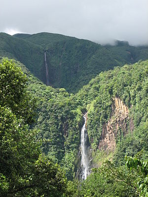
 Chutes you Carbet |
|
Capesterre-Belle-Eau ( Guadeloupe-Creole : Kapestè ) is a municipality with 18,270 inhabitants (as of January 1, 2017) in the French overseas department of Guadeloupe . The inhabitants call themselves Capesterriens .
geography
The village is located in the southeast of the island of Basse-Terre . The sea coast - Capesterre-Belle-Eau lies on the Caribbean Sea - is called, like the village, Cabesterre, a name that already existed in the 17th century. The municipality has a share in the Guadeloupe National Park and also contains other monuments.
history
The area that later became Capesterre-Belle-Eau was discovered on November 4, 1493 by Christopher Columbus , who, as is well known, believed to have reached India . The settlement began in the 17th century when the governor Charles Houël was sent by the Compagnie des îles d'Amérique , the American island company.
| Population development | |||||||
|---|---|---|---|---|---|---|---|
| year | 1961 | 1967 | 1974 | 1982 | 1990 | 1999 | 2014 |
| Residents | 16,085 | 17,912 | 18,143 | 17,472 | 19,012 | 19,568 | 19,107 |
Culture and sights
- Chutes you Carbet
- Rhum Longueteau distillery
- Changy Hindu Temple
Personalities
- Philippe-François Pinel Dumanoir (* 1806 in Capesterre, † 1865 in Pau ), playwright.