
Dörzbach
| coat of arms | Germany map | |
|---|---|---|

|
Coordinates: 49 ° 23 ' N , 9 ° 42' E |
|
| Basic data | ||
| State : | Baden-Württemberg | |
| Administrative region : | Stuttgart | |
| County : | Hohenlohe district | |
| Local government association: | Krautheim | |
| Height : | 242 m above sea level NHN | |
| Area : | 32.36 km 2 | |
| Residents: | 2485 (December 31, 2018) | |
| Population density : | 77 inhabitants per km 2 | |
| Postal code : | 74677 | |
| Area code : | 07937 | |
| License plate : | KÜN, EAR | |
| Community key : | 08 1 26 020 | |
| LOCODE : | DE DZB | |
| Community structure: | 4 districts | |
| Address of the municipal administration: |
Marktplatz 2 74677 Dörzbach |
|
| Website : | ||
| Mayor : | Andy Kümmerle | |
| Location of the municipality of Dörzbach in the Hohenlohe district | ||
  |
||

Dörzbach is a municipality in the Hohenlohe district in the Franconian north-east of Baden-Württemberg . It belongs to the Heilbronn-Franconia region (until May 20, 2003 Franconia region ).
geography
Geographical location
The municipality of Dörzbach is in the natural area of Kocher-Jagst Plains at heights between 230 and 430 m above sea level. NN and is traversed by the great north arch of the middle Jagst . The settlement areas are in the shell limestone valley of the river, in some side valleys and on the surrounding edge heights. The eponymous capital borders on the right bank of the Jagst; At the upper edge of the village the stream from the short donkey blade flows into it, at the edge of the center that from the somewhat longer gravel ditch, in the center of the village then the 5 km long Goldbach .
Community structure

The municipality Dörzbach consists of Dörzbach (1465 inhabitants) itself (with the houses Birkenhöfe and St. Wendel zum Stein), as well as from the incorporated former municipalities Hohebach (with the hamlets Eisenhutsrot, Heßlachshof and Wendischenhof, together 646 inhabitants), Laibach (183 inhabitants ) and Meßbach (170 inhabitants).
In the area of the municipality of Dörzbach within the borders of December 31, 1971, the abandoned villages Albertshof, Dürrenhof and Rortal are located. The abandoned villages of Lieboldsbronn, Eschbronnen and Ripperg are in the area of the former municipality of Hohebach. In the area of the former municipality of Laibach are the abandoned villages Büchelich and Dacht and in the area of the former municipality of Meßbach is the abandoned village of Niedermeßbach.
Division of space

According to data from the State Statistical Office , as of 2014.
history
Early days
Prehistoric finds, including from the Neolithic Age, indicate that Dörzbach and its suburbs were already around 3500 BC. Were settled. It has been proven that Dörzbach was already around 500 BC. Was settled by Celts . They built a rock and spring sanctuary.
middle Ages
Dörzbach an der Jagst was first mentioned in a document in 1230 under the name Torzebach. In 1583, Emperor Rudolf II granted the community of Dörzbach three market rights. This is the historical origin of the spring and autumn horse markets that are still held today.
The oldest remaining components of Eyb Castle date from the 12th century. Up to the 15th century the castle had a very eventful history with many owners and shareholders. In the late 14th century, the Lords of Berlichingen acquired the castle.
Modern times
The lords of Berlichingen remained the owners of the castle and palace complex until 1601. The von Eyb family has owned the complex, which has now been converted into a castle, since 1601 . Dörzbach was in the Franconian knight circle .
In 1831, Dörzbach tried to become an upper administrative city. However, since the corresponding letter was sent directly to King Wilhelm I of Württemberg and had not been submitted via the responsible Oberamt Künzelsau, the request was rejected.
population
Christianity
Evangelical parishes
There are two Protestant parishes in Dörzbach : The Trinity Church in Dörzbach and the Jakobuskirche in Hohebach.
Catholic parishes
In Dörzbach there is the parish of the Twelve Apostles Church , in Laibach the parish of St. Pius X of the Catholic Church.
Judaism
Jewish community Dörzbach
From the time of the Thirty Years' War to 1907, Dörzbach had a Jewish community with a synagogue , a Jewish school and a ritual bath . The community's dead were initially buried in the Jewish cemeteries in Unterbalbach , Laibach and Berlichingen , and after 1852 in Hohebach .
Jewish community in Hohebach
The Jewish community of Hohebach existed from the Middle Ages until 1942, when the last Jewish residents of the town were deported. Since 1986, a memorial plaque on the building of the former synagogue in the Hohebach district has been commemorating the church of the Jewish fellow citizens, which was demolished by SA men in the November pogrom in 1938 . In the Jewish cemetery there is a memorial stone for the last eight Jewish residents who were deported and killed in the 1940s.
Jewish community of Laibach
The Jewish cemetery there is a reminder of the Jewish community in the district of Laibach, which existed from the time of the Thirty Years' War until the middle of the 19th century . There are still 19 tombstones in it. In addition to the Jewish cemetery, the community had a prayer room.
politics
Municipal council
In Dörzbach, the municipal council is elected using the false sub-district election. The number of local councils can change due to overhang mandates . The municipality council in Dörzbach has 13 members after the last election (2009: 12). The municipal council consists of the elected voluntary councilors and the mayor as chairman. The mayor is entitled to vote in the municipal council. The mayor of Hohebach is an advisory member.
| Parties and constituencies |
% 2014 |
Seats 2014 |
% 2009 |
Seats 2009 |
||
| UWV | Independent electoral association | 55.9 | 7th | 56.9 | 7th | |
| CDU | Christian Democratic Union of Germany | 44.1 | 6th | 43.1 | 5 | |
| total | 100.0 | 13 | 100.0 | 12 | ||
| voter turnout | 64.8% | 63.8% | ||||
badges and flags
The blazon of the Dörzbach coat of arms reads: Three (2: 1) red shells above a four-fold silver and red bar in silver, including a five-spoke silver wheel in black. The community's flag is red and white.
On June 27, 1583, Emperor Rudolf II granted Dörzbach, together with the market rights, a coat of arms that connected the wheel from the Lords of Berlichingen with the bar from the coat of arms of an extinct local noble family. After Dörzbach was sold to the Lords of Eyb in 1601, the Eyb shells ( scallops with the joint turned upwards ) replaced the wheel in the upper half of the shield. In 1931 the municipality added the Berlichingen wheel to the lower (blue) half of the shield. Incorrect tinging of the shield base of the heraldic figures wheel and shells were later corrected. The flag was awarded to the municipality on February 2, 1970 by the Baden-Württemberg Ministry of the Interior and the coat of arms was confirmed.
Culture and sights
Buildings and cultural monuments
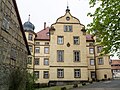
There are a total of three castles in the municipality of Dörzbach, including a former moated castle of the Lords of Berlichingen , who moved into the center of Dörzbach in 1371 and replaced the original Lords of Torcebach as local rule. In 1601 the castle ⊙ was bought by the Lords of Eyb , who still own it today. The palace complex includes both the inner courtyard, framed on four sides, and the larger outer courtyard, which is surrounded by farm buildings. The tower of the Evangelical Trinity Church from the 13th century was originally built as a defensive tower and was part of the area.
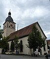
Church in Dörzbach
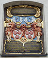
Inscription for renovation by members of the von Eyb family

Access to the courtyard of Eyb Castle

Eyb Castle
Meßbach Castle

Holy Trinity Church in Meßbach

The interior of the church in Meßbach

Church ceiling fresco


.jpg)


_3.jpg)
Laibach Castle, owned by the Barons of Racknitz, stands on a right-hand valley spur above the district of Laibach . Once a permanent (robber baron) castle, it was rebuilt in 1621 by Erhard von Muggenthal into a stately mansion in the Renaissance style.
In the district of Meßbach, next to the rococo church of the Holy Trinity, built in 1776 and decorated with beautiful ceiling paintings, there is the palace of the Barons von Palm . ⊙ It is an elongated square building with three floors and four round, coupled towers at the corners of the building. The castle was probably built before 1750, but was not completed by the Lords of Eyb until later.

Hohebach is the only suburb that does not have a baron castle, but a royal bridge.
The huge four-arch stone bridge was built from 1808 to 1810 by Karl August Friedrich von Duttenhofer at the behest of King Friedrich I of Württemberg, who wanted to connect his Napoleonically newly acquired northern part of Hohenlohe strategically and in terms of transport to the Swabian heartland. A high sandstone column in the middle of the bridge bears the Roman year MDCCCX and the royal monogram FR with the national coat of arms. According to Carl Julius Weber, it is "the most beautiful bridge in the entire Kingdom of Württemberg". Towards the end of the Second World War , the two northern arches of the bridge were blown up and rebuilt in 1947. From 1996 to 1998 the bridge, over which the Federal Highway 19 now runs, was repaired and widened while maintaining its design.
In 2001 Dörzbach won the gold medal in the state competition Our village should become more beautiful .
St. Wendel zum Stein

Between Dörzbach and Hohebach, in front of a limestone rock, is the St. Wendel zum Stein chapel with a sacristan's house, in the middle of the nature reserve of the same name. Evidence of earlier chapels and caves inhabited from the Ice Age are preserved in the rock face. In recent times, services and devotions have been celebrated in the chapel.
In the summer of 2006, the paths of silence were inaugurated in the central Jagst valley . The St. Wendel Chapel is located on the route in the Dörzbacher section, directly above the chapel the Kocher-Jagst cycle path leads over the Maifestplatz .
Economy and Infrastructure
Jagst Valley Railway

The departure station of the Jagst Valley Railway, a narrow-gauge railway that used to be important regionally, is located in Dörzbach . The Jagst Valley Railway (gauge 750 mm) had always been operated as a private railway. The execution of the steam tram route planned in 1888 from Züttlingen via Dörzbach to Bad Mergentheim was modified to a narrow-gauge railway. The opposite starting point of the railway was moved from Züttlingen to the larger Möckmühl , where there was also a connection to the main Heilbronn - Lauda line . The branch line was put into operation in December 1900. Until 1951 there was freight and passenger traffic. Passenger traffic (school transport) was temporarily resumed in 1967. In 1971, the German Society for Railway History (DGEG) set up one of the first museum railway operations ( steam locomotives ) in Germany here in the summer months in cooperation with the SWEG . On December 23, 1988, all operations were discontinued due to defects in the superstructure.
Efforts to restart operation between Dörzbach and Krautheim resulted in the establishment of the municipal Jagsttalbahn AG in 2002 .
The Friends of the Jagst Valley Railway are active in Dörzbach. He runs an engine shed. Starting from this, a museum is to be resumed on a small part of the former route.
.jpg)
Laibach quarry
A little north of the Dörzbach district of Laibach there is a shell limestone quarry with gravel in the Wanzenäcker right slope of the Laibach valley.
traffic
Road traffic
Dörzbach is located on the federal road 19 (B 19), which leads from Schwäbisch Hall in the south via the Kupferzell junction on the federal motorway 6 (A 6) to Hohebach and Dörzbach and then on to Bad Mergentheim in the north.
This main traffic axis crosses in Dörzbach with the scenic Jagsttalstraße. This begins its course on the previously pathless bottom of the upper valley, initially as the district road K 2542 near Leofels, northwest of Crailsheim and a little west of Kirchberg an der Jagst , which has a junction with the A 6 , and then settles at the foot of Langenburg as a state road L 1025 over Hohebach and Dörzbach for a long time to Möckmühl shortly after the bridge of the A 81 spanning the valley . At the edge there is a connection to this motorway, while the Jagsttalstraße continues with changing numbers as a state road to Bad Friedrichshall -Jagstfeld, where it meets the B 27 .
Public transportation
Verkehrsbetrieb Dörzbach, a subsidiary of Südwestdeutsche Verkehrs AG , provides public transport by means of several bus routes . The tariff of the Hohenlohekreis local transport applies .
Ultralight airfield
On the Hag am Wendischenhof, southwest of the Hohebach district, the Ultraleicht-Verein Dörzbach e. V. an ultra-light airfield .
Viticulture
Dörzbach is a wine-growing community whose vineyards belong to the large Kocherberg site in the Kocher-Jagst-Tauber area. The place is on the Württemberg Wine Route . The Altenberg site was transversely terraced to improve the cultivation of the steep vineyards . The wines are marketed through the Kochertalkellerei cooperative.
Sons and daughters of the church
- Hermann Röger (1883–1954), senior administrator and district administrator in Württemberg
- Richard Ruoff (1883–1967), officer , most recently Colonel General during the Second World War
- Ilse Junkermann (* 1957), regional bishop of the Evangelical Church in Central Germany
Individual evidence
- ↑ State Statistical Office Baden-Württemberg - Population by nationality and gender on December 31, 2018 (CSV file) ( help on this ).
- ↑ Wolf-Dieter Sick : Geographical land survey: The natural space units on sheet 162 Rothenburg o. D. Deaf. Federal Institute for Regional Studies, Bad Godesberg 1962. → Online map (PDF; 4.7 MB)
- ^ The state of Baden-Württemberg. Official description by district and municipality. Volume IV: Stuttgart district, Franconian and East Württemberg regional associations. Kohlhammer, Stuttgart 1980, ISBN 3-17-005708-1 , pp. 184-187.
- ↑ State Statistical Office, area since 1988 according to actual use for Dörzbach.
- ^ Hohenlohekreis: Hohenlohekreis: Dörzbach. Online at www.hohenlohekreis.de, accessed on October 26, 2014
- ↑ Alemannia Judaica: Dörzbach (Hohenlohekreis) Jewish history / prayer hall / synagogue online at www.alemannia-judaica.de. Retrieved December 16, 2015.
- ^ A b Alemannia Judaica: Hohebach (community Dörzbach, Hohenlohe district) Jewish history / prayer hall / synagogue online at www.alemannia-judaica.de. Retrieved December 16, 2015.
- ↑ Memorial sites for the victims of National Socialism. A documentation, Vol. I, Bonn 1995, p. 31, ISBN 3-89331-208-0 .
- ↑ Alemannia Judaica: Laibach (community Dörzbach, Hohenlohekreis) Jewish history / prayer hall / synagogue online at www.alemannia-judaica.de. Retrieved December 16, 2015.
- ↑ Heinz Bardua: The district and community coats of arms in the Stuttgart administrative region . Theiss, Stuttgart 1987, ISBN 3-8062-0801-8 (District and municipal coat of arms in Baden-Württemberg, 1), p. 55.
Web links
- ditto Hohebach , Laibach , Meßbach and Steinkirchen
- Paths of Silence, Dörzbach section

Bretzfeld | Dörzbach | Forchtenberg | Ingelfingen | Krautheim | Künzelsau | Copper cell | Mulfingen | Neuenstein | Niedernhall | Öhringen | Pfedelbach | Schöntal | Waldenburg | Weissbach | Doubts